 Catalogue Shom
elevation
Type of resources
Available actions
Topics
Keywords
Provided by
Years
Formats
Representation types
Update frequencies
status
Scale
Resolution
-
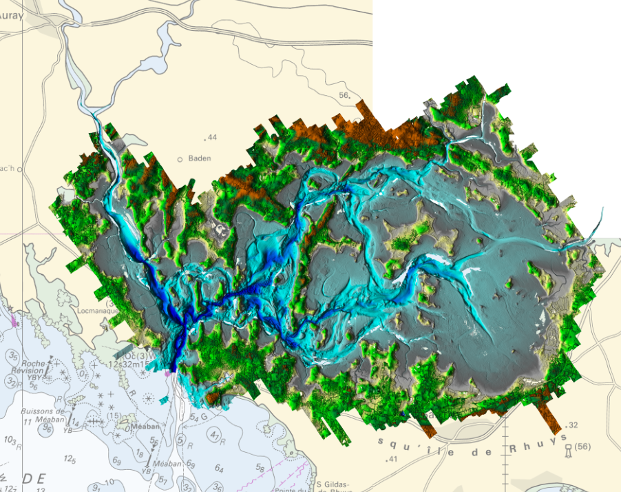
Litto3D Marine Part is an intermediate product of the Litto3D product containing only marine data.Litto3D is a unique and continuous land-sea database which can provide 3D models of the shape and location of French coastal terrain. A line separates sea and land data acquisition zones, and the associated survey readings obtained using bathymetric lidar technologies or multibeam echosounders for sea readings and airborne lidar topographical surveys for land readings, with 300 m overlap. Litto3D digital models are available in two formats: a set of 3D points and a qualified terrain mesh.
-

The bathymetric DEM for the coasts of Guadeloupe and Martinique with a resolution of 0.001° (~ 100 m) was prepared as part of the HOMONIM project. The DEM covers some of the Lesser Antilles islands, from Anguilla in the north to Saba in the south. The model ranges off-shore to a depth of 3275 m. The DEM is designed to be used in hydrodynamic models in order to produce high-precision forecasts for coastal water levels and sea conditions and therefore improve the pertinence of the Waves-Submersion monitoring programme.
-
The coastal topobathymetric DEM of Ré Island's surroundings, with a resolution of 0.00005° (~5 meters), was created by Shom as part of the HOMONIM-3 project. It covers the coast of the municipalities of Ars-en-Ré and Saint-Clément-des-Baleines, extending offshore to a depth of about 20 meters, to the west of the Phare des Baleines lighthouse. This DEM is designed for use in hydrodynamic models to enhance the modeling of coastal processes, particularly forecasting submersion risk. The product complements the coastal topobathymetric DEM of the Pertuis-Charentais, with a resolution of 0.0002° (~20 meters), and the bathymetric DEM of the Atlantic coast, with a resolution of 0.001° (~100 meters). The vertical reference for this product is the Lowest Astronomical Tide (LAT).
-
Litto3D is a unique and continuous land-sea database which can provide 3D models of the shape and location of French coastal terrain. A line separates sea and land data acquisition zones, and the associated survey readings obtained using bathymetric lidar technologies or multibeam echosounders for sea readings and airborne lidar topographical surveys for land readings, with 300 m overlap. Litto3D digital models are available in two formats: a set of 3D points and a qualified terrain mesh.
-

This data layer contains the current status of hydrographic knowledge expressed in terms of CATZOC (category of zone of confidence, cf. https://iho.int/uploads/user/pubs/standards/S-67/S-67%20Ed%201.0.0%20Mariners%20Guide%20to%20Accuracy%20of%20Depth%20Information%20in%20an%20ENC_EN.pdf), as well as the target defined by the national hydrography program.
-
The coastal topo-bathymetric DTM of the Arcachon basin and its surroundings at a resolution of 0.0002° (~ 20 m) was produced as part of the HOMONIM project. The DTM covers the coastline of a part of the Gironde department, from the Carcans and Hourtin ponds in the North, to the Cazaux and Sanguinet lakes in the South. It covers the entire Arcachon basin and extends offshore to about 40 m depth. The DTM is intended to be implemented in hydrodynamic models in order to produce accurate forecasts of water heights and sea states at the coast and to improve the French storm surge warning system.
-

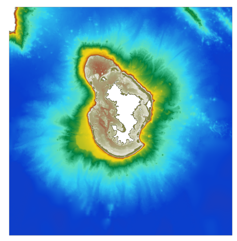
The bathymetric DEM of Tahiti and Moorea with a resolution of 0.001° (~ 100 m) was produced by the Shom for Météo-France (Inter-regional Direction in French Polynesia). This DEM covers a 10 km radius around the islands of Tahiti and Moorea in order to meet the need for marine submersions modelling in French Polynesia. This product is available at different vertical references, either the lowest astronomical tide (LAT) or the mean sea level (MSL).
-
The coastal topobathymetric DEM of Ré Island's surroundings, with a resolution of 0.00005° (~5 meters), was created by Shom as part of the HOMONIM-3 project. It covers the coast of the municipalities of Ars-en-Ré and Saint-Clément-des-Baleines, extending offshore to a depth of about 20 meters, to the west of the Phare des Baleines lighthouse. This DEM is designed for use in hydrodynamic models to enhance the modeling of coastal processes, particularly forecasting submersion risk. The product complements the coastal topobathymetric DEM of the Pertuis-Charentais, with a resolution of 0.0002° (~20 meters), and the bathymetric DEM of the Atlantic coast, with a resolution of 0.001° (~100 meters). The vertical reference for this product is Mean Sea Level (MSL).
-

Lidar marine part is a unique and continuous land-sea database which can provide 3D models of the shape and location of French coastal terrain. A line separates sea and land data acquisition zones, and the associated survey readings obtained using bathymetric lidar technologies or multibeam echosounders for sea readings and airborne lidar topographical surveys for land readings, with 300 m overlap. Litto3D digital models are available in two formats: a set of 3D points and a qualified terrain mesh.
-
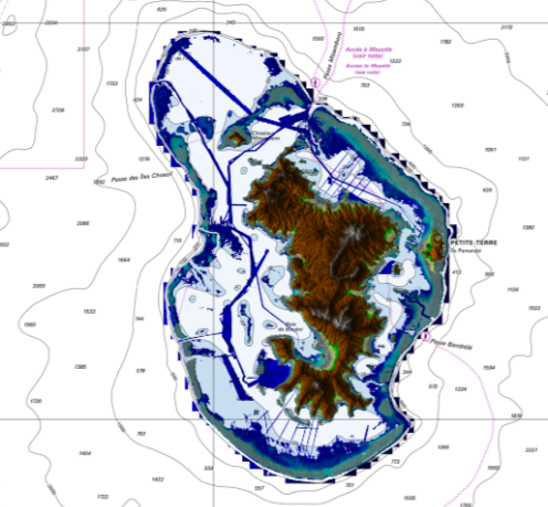
The bathymetric DEM for the coasts of Mayotte with a resolution of 0.001° (~ 100 m) was prepared as part of the HOMONIM project. It covers the entire island of Mayotte and extends to Anjouan island in the west. The model ranges off-shore to a depth of 3700 m. The DEM is designed to be used in hydrodynamic models in order to produce high-precision forecasts for coastal water levels and sea conditions and therefore improve the pertinence of the Waves-Submersion monitoring programme. This product is available with the Lowest Astronomic Tide (LAT) or the Mean Sea Level (MSL) as a vertical datum.