 Catalogue Shom
Elevation
Type of resources
Available actions
Topics
Keywords
Provided by
Years
Representation types
Update frequencies
status
Scale
Resolution
-

Bathymetric datasets are an extraction of surveys belonging to the Shom public database. For depth up to 50m, the vertical precision of soundings varies from 30cm to 1m and the horizontal precision varies from 1 to 20m. In deep ocean, the vertical precision is mainly around 1 or 2% of the bottom depth. It is sometimes more, it depends on the technology used. The data are referenced to 066 Nouvelle Caledonie - La Poya (ZH) which is assimilated to LAT. Data are corrected for sound velocity variations. Data are acquired during the campaign S198803000 (http://dx.doi.org/10.17183/S198803000). // Instruments: Sondeur DESO 20 // Number of soundings: 1673 // DOI: http://dx.doi.org/10.17183/LOTS_BATHY#S198803000-1
-

Bathymetric datasets are an extraction of surveys belonging to the Shom public database. For depth up to 50m, the vertical precision of soundings varies from 30cm to 1m and the horizontal precision varies from 1 to 20m. In deep ocean, the vertical precision is mainly around 1 or 2% of the bottom depth. It is sometimes more, it depends on the technology used. The data are referenced to 146 France - Camaret (ZH) which is assimilated to LAT. Data are corrected for sound velocity variations. Data are acquired during the campaign S196900100 (http://dx.doi.org/10.17183/S196900100). // Instruments: Sondeur KELVIN-HUGHES // Number of soundings: 5447 // DOI: http://dx.doi.org/10.17183/LOTS_BATHY#S196900100-10
-
For more than 200 years, Shom has maintained a bathymetric knowledge base enriched by surveys and campaigns over time. They are composed of point clouds which have a density higher than those shown on nautical charts. Datasets are stored in the Shom Bathymetric Database (BDBS) which is a source to describe seabed reliefs. These data are useful for many applications as oceanographic modeling or seabed exploitations. The bathymetric datasets have been granted a distribution agreement. Data are not modeled. This modeling is left to the initiative of the customers. In other terms, they are point clouds data on the field, treated to the hydrographic standards in force at the time of their acquisition and validated. The product is composed of bathymetric datasets which cover the entire French Exclusive Economic Zone (EEZ) as well as international waters. The cover and its cutting are available on the Shom portals (data.shom.fr). Data positions are provided in geographic coordinates reported to the World Reference Geodetic System WGS84. They are vertically referenced to the zero of the soundings reduction which is usually associated to the hydrographic Chart Datum of the corresponding area. For depths up to 50m, the data vertical accuracy varies from 30cm to 1m and the planimetric accuracy varies from 1 to 20m. Beyond, in deep seas, the vertical accuracy is mainly of the order of 1 to 2% of the bottom depth. Sometimes, it is higher depending on the technology used.
-
Product replaced by Litto3D® - Brittany 2018-2021. https://services.data.shom.fr/geonetwork/srv/fre/catalog.search#/metadata/BATHYMETRIE_LITTO3D_BZH_2018_2021.xml
-

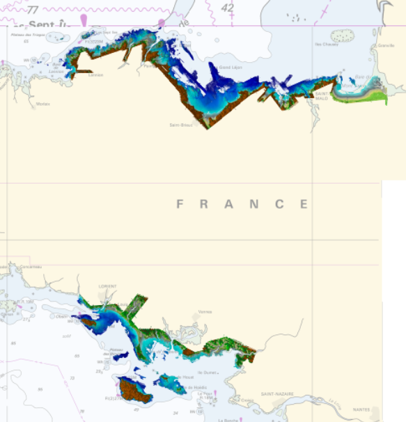
Litto3D® is a unique and continuous land-sea database which provide 3D models of french coastal areas. Surveys are carried out by airborne lidar bathymetry over the sea side and airborne lidar topography over the land up to 2km inland. Litto3D® digital models are available in two formats: a set of 3D points and a digital terrain model. The product "Litto3D® - Brittany 2018-2021" covers the coastline and islands of Côtes d'Armor, Ille-et-Vilaine and Morbihan departments.
-
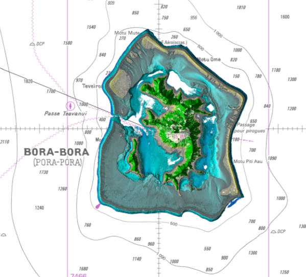
Lidar marine part is a unique and continuous land-sea database which can provide 3D models of the shape and location of French coastal terrain. A line separates sea and land data acquisition zones, and the associated survey readings obtained using bathymetric lidar technologies or multibeam echosounders for sea readings and airborne lidar topographical surveys for land readings, with 300 m overlap. Litto3D digital models are available in two formats: a set of 3D points and a qualified terrain mesh. The product Bora Bora SAU 2015 v.20160630 covers a geographical area corresponding to the whole island, the lagoon and the reef of Bora Bora.
-

Litto3D provides 3D, continuous sea-land description of French coastal areas. Data is acquired by airborne topo-bathymetric LiDARs. Litto3D products come in 3D point clouds and digital terrain models formats. Litto3D Saint-Pierre-and-Miquelon product covers land area of the islands as well as bathymetry down to approx. 20m.
-

Litto3D provides 3D, continuous sea-land description of French coastal areas. Data is acquired by airborne topo-bathymetric LiDARs. Litto3D products come in 3D point clouds and digital terrain models formats. The product "Litto3D - Nouvelle-Aquitaine 2020-2022" covers the geographical area from the Charente-Maritime to the Spanish border. For the maritime part, the data produced by Shom extend offshore down to signal extinction, approximatively 20 depth when environmental conditions are optimal. On land, the data are truncated at a limit that ensures the product retain its coastal character.
-
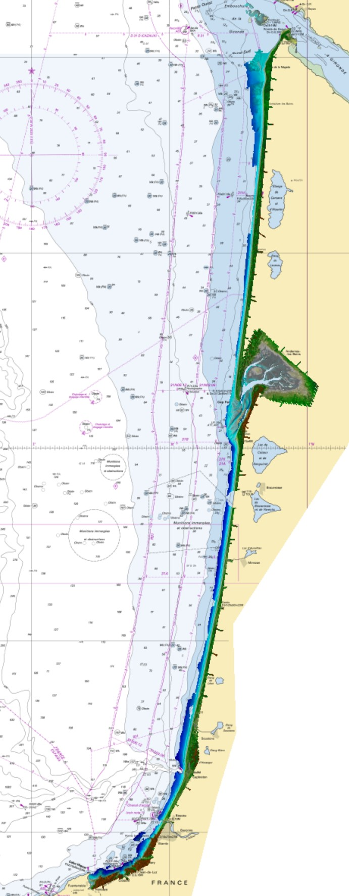
Litto3D marine part is a unique and continuous land-sea database which can provide 3D models of the shape and location of french coastal terrain. Surveys are carried out by airborne lidar bathymetry over the sea side and airborne lidar topography over the land side up to 400m inland. Litto3D marine part digital models are available in two formats: a set of 3D points and a qualified terrain mesh. The product "Litto3D marine part - Nouvelle-Aquitaine 2020-2022" covers the geographical area from the Sèvre Niortaise to the Spanish border.
-
Bathymetric datasets, collected between 1990 and 2005, are digital data controlled and qualified. They are acquired with single-beam echosounders and the first generations of multi-beam echosounders.