 Catalogue Shom
150000
Type of resources
Available actions
Topics
Keywords
Provided by
Years
Formats
Representation types
Update frequencies
status
Scale
-
Seamless Shom nautical charts - West Africa - EAtHC is a product composed of digital images taken from Shom nautical charts, with no additions, legends or georeferencing information. At a given scale, it is possible to view only the maps with a scale that allows a correct display. The footprint of all the maps composing this product are shown. Unless exceptional circumstances apply, this product is updated on a monthly basis and the modified grid squares are re-published, replacing the previous versions. All corrections, publications and editions with an effect on the reference nautical charts are taken into consideration.
-
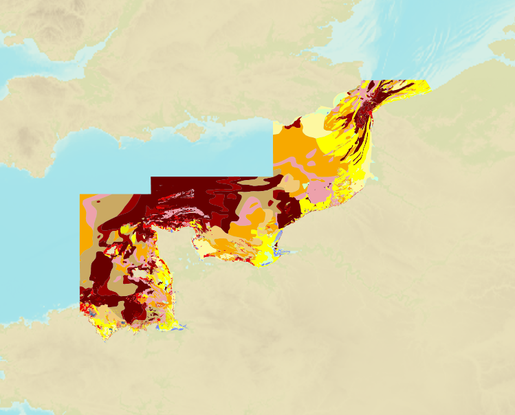
The product is a digital solution showing superficial sediments on the sea floor along coasts in mainland France.
-
Seamless Shom nautical charts - West Africa is a product composed of digital images taken from Shom nautical charts, with no additions, legends or georeferencing information. At a given scale, it is possible to view only the maps with a scale that allows a correct display. The footprint of all the maps composing this product are shown. Unless exceptional circumstances apply, this product is updated on a monthly basis and the modified grid squares are re-published, replacing the previous versions. All corrections, publications and editions with an effect on the reference nautical charts are taken into consideration.
-
Image numérique scannée non géoréférencée de la 3664 Date de publication : 1878 Date de révision : 1906 Support de l'original: papier Dimensions : 1079mm x 765mm Description : D'après le levé exécuté en 1874 par le capitaine H. C. Saint John de la Marine Royale anglaise. Les longitudes sont rapportées à celle de Yokohama(Mole de la douane japonaise) pour laquelle on adopte 137° 20' 18" Est. La longitude du même point est d'après le sanglais de 137° 18' 37.45". Nota : La partie de côte au Nord de la Baie Tamabé est empruntée à la carte de la Mer Intérieure. Par L. Manen, ingénieur hydrographe. Août 1887 : La longitude adoptée pour Yokohama Naval Hôpital Square étant 137° 19' 5" E, celle du Môle de la douane japonaise devient 137° 18' 35" E au lieu de 137° 20' 18" E, toutes les longitudes de cette carte doivent être diminuées de 0° 1' 43".
-
Le produit "Natures de fond au 150 000" est un produit numérique décrivant la nature des sédiments superficiels des fonds sous-marins le long des côtes métropolitaines.
-
Mesaieed (Musay 'id or Umm Said) to Ra's Laffān; Qatar and United Arab Emirates; Cartes de cabotage; Édition 5 du 30/08/2017
-
West Inder and Outer Gabbard to Vlissingen and Scheveningen; North Sea - Netherlands; Cartes de cabotage; Édition 8 du 02/01/2019
-
Nísos Kálymnos to Nísos Ikaría including Güllük Körfezi; Aegean Sea - Greece and Turkey; Cartes de cabotage; Édition 3 du 27/05/2015
-
Nísos Ios to Vrachonisída Kandelioússa; Aegean Sea - Greece; Cartes de cabotage; Édition 3 du 02/08/2017
-
DW Routes to Ijmuiden and Texel; North Sea - Netherlands; Routiers et planisphères; Édition 5 du 08/08/2018