 Catalogue Shom
boundaries
Type of resources
Available actions
Topics
Keywords
Contact for the resource
Provided by
Years
Formats
Representation types
Update frequencies
Scale
-
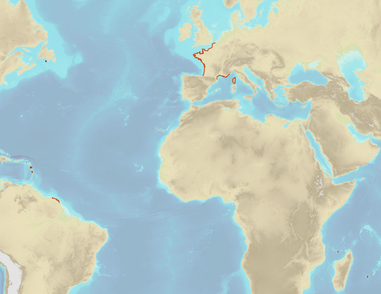
The combined error grid of the SIO V31 gravity anomaly model (D. T. Sandwell, H. Harper, B. Tozer et al., Gravity field recovery from geodetic altimeter missions, Advances in Space Research, https://doi.org/10.1016/j.asr.2019.09.011) is computed with a method described in a paper submitted to Earth and Space Science (AGU). The model’s extension is North Atlantic.
-
The exclusive economic zone is adjacent to the territorial sea and extends to a maximum distance of 200 nautical miles calculated from the baselines. This is a space in which the coastal State do not practice its entire sovereignty but only the following rights: - sovereign rights over the water column, the bed and subsoil for the purposes of: - exploration, exploitation, conservation and management of natural resources, whether biological or not; - exploration and exploitation of the zone for economic purposes, such as the production of energy from water, currents and wind; - jurisdiction concerning the following fields: - construction and use of artificial islands, facilities and works; - marine scientific research; - protection and preservation of the marine environment. Apart from the rights and obligations of the coastal States cited above, the exclusive economic zone is a space open to the exercise by any other State of the freedoms set down in the United Nations Convention on the law of the sea (UNCLOS) (navigation, overflight, etc.), within the limits set by the Convention.
-
In compliance with Article 57 of UNCLOS, the outer limit of the exclusive economic zone (EEZ) is located at 24 nautical miles from the baselines. This limit distinguishes the EEZ from the High Sea. Beyond this limit, an extension of the continental shelf is possible subject to the criterias of Article 76 of UNCLOS. The objects of the theme "Outer limit of the exclusive economic zone" result from Shom computations and are compliant with Article 10 of the French Order No 2016-1687 of 8 December 2016. They are published by decree of the French Republic.
-
In the Law of the Sea, the continental shelf located beyond 200 nautical miles affects the seabed and its subsoil on which the coastal State exerts sovereign rights for purposes of exploration and exploitation of its natural ressources. In those areas, the wealth generated by the exploitation of the natural ressources are shared via the International Seabed Authority between the States which have signed UNCLOS (in particular with the developping States or the ones which do not have access to the sea). The outer limit of the continental shelf beyond 200 nautical miles is determined in compliance with the criterias of Article 76 of UNCLOS and notably by the examination of a submission deposited by the Coastal State to the Commission for the Limits of the Continental Shelf (CLCS). the outer limit of the French continental shelf beyond 200 nautical miles is the final result of the national program EXTRAPLAC after the adoption of recommandations by CLCS, the delineation of the attributed areas with neighbouring States if necessary and the publication by decree. The theme "Outer limit of the continental shelf beyond 200 nautical miles" gathers the limits of the extended continental shelf which has been recommended by CLCS and published by a decree of the French Republic.
-
Compilation of marine gravity surveys acquired in the Northeast Atlantic by Shom between 2001 and 2016. These surveys were compiled to perform a quantification of the error of the gravity anomaly models derived from satellite altimetry. This dataset represents more than 22,000 measurement points distributed in 9 ascii survey files sampled at 1 kilometer. The file’s format is as follows: longitude latitude Gravity_anomaly error line_label.
-
French Ministry of Culture / DRASSM – Shom The product "Limit of preventive archeology licence fee" contains the limits for the preventive archeology licence fee (1 nautical mile) as defined in the French Heritage Code. This limit is managed by the Department of Underwater Archeological Research (DRASSM) of the Ministry of Culture. This limit, defined by the Heritage Code at 1 nautical mile from the low-water line, permits to delineate the areas where the licence fee for preventive archeology at sea is applied. In Mainland France in the Gironde estuary, the limit for the preventive archeology licence fee is stopped by the crosswise limit of the sea as defined by the decree of 26 August 1857. In French Guiana, the limit for the preventive archeology licence fee is stopped in Maroni and Oyapock rivers by the crosswise limits of the sea respectively defined the order of 30 January 1991 and the order No 863 of 26 May 1986, until meeting the land boundary which delineates the rivers with the neighbouring States. The product "Limit of preventive archeology licence fee" is to use in addition to the digital product “Maritime Limits and Boundaries” of Shom (French: “Délimitations maritimes”) which represents the limits of the French maritime spaces of sovereignty or jurisdiction through the World. The product “Maritime Limits and Boundaries” (French: “Délimitations maritimes”) can be viewed on data.shom.fr (Maritime boundaries Category) and downloaded on the French national portal of maritime limits (https://maritimelimits.gouv.fr).
-
The Regulation (EU) No 1380/2013 of European Parliament and Council of 11 December 2013, in its second paragraph of Article 5, authorises Member States to establish coastal waters along its coasts. Those areas enable member States to restrain fisheries to specific species to specific Member States following precise rules (quotas, limited fishery season). The description of the French coastal waters is established in Part 6 of Appendix 1. The coastal waters extend from 6 nautical miles from in force baselines to 12 nautical miles from in force baselines. Only portions of the French coasts are concerned.
-
French Ministry of Agriculture and Food / DRASSM - Shom<br /> The product "Limits related to fishery uses" contains the limits related to fishery uses as defined in the French or European legislations. Those limits are managed by the Directorate for Sea Fisheries and Aquaculture (DPMA) of the Ministry of Agriculture and Food. <br /> Those limits are divided into three categories : <br /> - the inner limit of the coastal waters (6 nautical miles) ; <br /> - the 3-nautical-mile limit ; <br /> - the limit of fisheries for overseas territories (100 nautical miles).<br /><br /> The product "Limits related to fishery uses" is to use in addition to the digital product “Maritime Limits and Boundaries” of Shom (French: “Délimitations maritimes”) which represents the limits of the French maritime spaces of sovereignty or jurisdiction through the World.<br /> The product “Maritime Limits and Boundaries” (French: “Délimitations maritimes”) can be viewed on data.shom.fr (Maritime boundaries Category) and downloaded on the French national portal of maritime limits (https://maritimelimits.gouv.fr).
-
In the absence of a maritime boundary agreement with a neighbouring State, the French Republic can unilateraly claim a delimitation. This boundary has indeed a provisional aspect pending the ratification of a boundary agreement. The theme "Maritime limits unilaterally claimed" gathers those limits unilaterally claimed by France. Some of those elkements are published by decree.