 Catalogue Shom
ArcGis Grid
Type of resources
Available actions
Topics
Provided by
Years
Formats
Representation types
Update frequencies
status
Scale
Resolution
-
The coastal topobathymetric DEM of Ré Island's surroundings, with a resolution of 0.00005° (~5 meters), was created by Shom as part of the HOMONIM-3 project. It covers the coast of the municipalities of Ars-en-Ré and Saint-Clément-des-Baleines, extending offshore to a depth of about 20 meters, to the west of the Phare des Baleines lighthouse. This DEM is designed for use in hydrodynamic models to enhance the modeling of coastal processes, particularly forecasting submersion risk. The product complements the coastal topobathymetric DEM of the Pertuis-Charentais, with a resolution of 0.0002° (~20 meters), and the bathymetric DEM of the Atlantic coast, with a resolution of 0.001° (~100 meters). The vertical reference for this product is Mean Sea Level (MSL).
-
Le produit topo-bathymétrique côtier de la zone "Morbihan" à une résolution de 0.0002° (~20 m) a été réalisé dans le cadre du projet TANDEM (Programme Investissements d'Avenir, ANR-11-RSNR-00023-01). Il couvre un secteur en-globant majoritairement le département du Morbihan et une partie de celui de la Loire-Atlantique. Ce MNT s’étend de la presqu'île de Gâvres au nord-ouest jusqu'à La Baule au sud-est, il englobe le golfe du Morbihan, la baie et la presqu'île de Quiberon, les îles d'Houat, Hoëdic et Belle-Ile, l'estuaire de la Vilaine… Ce MNT est destiné à être implémenté dans les modèles hydrodynamiques du projet TANDEM afin d'estimer les effets côtiers des tsunamis pour l’Atlantique et la Manche, où sont installées les centrales nucléaires françaises depuis environ 30 ans. La référence verticale de ce produit est le niveau des plus basses mers astronomiques.
-
The coastal topobathymetric DEM of Ré Island's surroundings, with a resolution of 0.00005° (~5 meters), was created by Shom as part of the HOMONIM-3 project. It covers the coast of the municipalities of Ars-en-Ré and Saint-Clément-des-Baleines, extending offshore to a depth of about 20 meters, to the west of the Phare des Baleines lighthouse. This DEM is designed for use in hydrodynamic models to enhance the modeling of coastal processes, particularly forecasting submersion risk. The product complements the coastal topobathymetric DEM of the Pertuis-Charentais, with a resolution of 0.0002° (~20 meters), and the bathymetric DEM of the Atlantic coast, with a resolution of 0.001° (~100 meters). The vertical reference for this product is the Lowest Astronomical Tide (LAT).
-
Modèle bathymétrique (MNT) de la Zone de Protection Ecologique de Méditerranée. Les données bathymétriques dont la profondeur est supérieure à 200 m (au delà du rebord du plateau continental) proviennent des levés par sondeurs multifaisceau de l'IFREMER. Les données du plateau continental (inférieures à 200 m) proviennent des levés hydrographiques et de la base de données du SHOM. Le pas de la grille est de 250 mètres.
-
The update of the coastal topo-bathymetric DEM of the Pertuis charentais at a resolution of 0.0002° (~ 20 m) was carried out in the third phase of the HOMONIM project. The DEM extends from the terrestrial domain to about 60 meters depth over all the pertuis (pertuis Breton, pertuis d’Antioche and pertuis of Maumusson). The DEM is intended to be implemented in hydrodynamic models in order to produce forecasts as accurate as possible of water heights and sea states at the coast to improve the relevance of the Wave-Submergence Vigilance. The vertical reference for this product is the Lowest Astronomical Tide (LAT).
-
The bathymetric DEM of Tahiti and Moorea with a resolution of 0.001° (~ 100 m) was produced by the Shom for Météo-France (Inter-regional Direction in French Polynesia). This DEM covers a 10 km radius around the islands of Tahiti and Moorea in order to meet the need for marine submersions modelling in French Polynesia. The vertical reference for this product is Mean Sea Level (MSL).
-
Le MNT bathymétrique de façade de La Réunion à une résolution de 0.001° (~ 111 m) a été réalisé dans le cadre du projet HOMONIM. Il couvre intégralement l'île de La Réunion et s'étend vers le large jusqu'à plus de 4000 m de profondeur. Le MNT est destiné à être implémenté dans les modèles hydrodynamiques afin de produire des prévisions aussi précises que possible des hauteurs d’eau et d’états de mer à la côte et donc d’améliorer la pertinence de la Vigilance Vagues-Submersion.
-
The bathymetric DEM for the coasts of La Réunion with a resolution of 0.001° (~ 100 m) was prepared as part of the HOMONIM project. The DEM covers the entire Reunion island. The model ranges off-shore to a depth of 4000 m. The DEM is designed to be used in hydrodynamic models in order to produce high-precision forecasts for coastal water levels and sea conditions and therefore improve the pertinence of the Waves-Submersion monitoring programme.
-
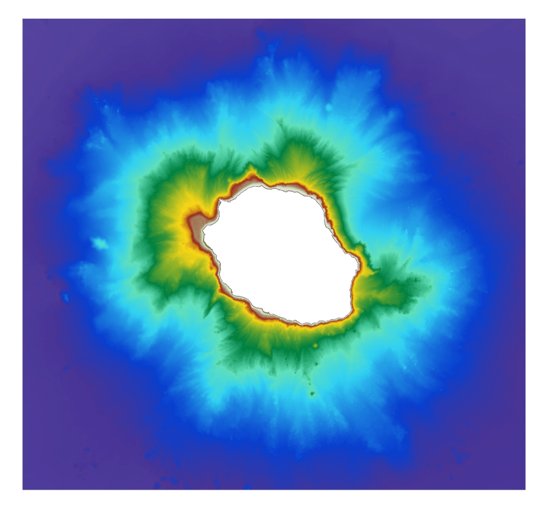
Le MNT topo-bathymétrique côtier de l'Île de La Passion – Clipperton à une résolution de 20 m a été réalisé en valorisant les données bathymétriques et topographiques acquises entre 2012 et 2015 par le Shom et l'équipe du programme PASSION. La grille côtière à 20 m comprend l'atoll de La Passion – Clipperton et ses flancs immédiats jusqu'à environ 1500 m de profondeur. L'Île de La Passion - Clipperton, située dans l'Océan pacifique Est, est un atoll inhabité isolé à plus de 5000 km de Tahiti en Polynésie Française et plus de 1000 km des côtes mexicaines. L'île est le point culminant, et le seul émergé, de la dorsale de Clipperton. Il s'agit du seul atoll corallien du Pacifique oriental situé dans l'hémisphère nord, par 109°de longitude Ouest et 10° de latitude Nord.
-

The bathymetric DEM for the coasts of New-Caledonia with a resolution of 0.001° (~ 100 m) was prepared in the framework of a Shom-IRD partnership as part of the TSUCAL project. The DEM covers the basin from New Caledonia in the west to the Vanuatu archipelago in the east. The DEM is designed to be used in hydrodynamic models in order to improve the pertinence of the Waves-Submersion monitoring programme.