 Catalogue Shom
GRD
Type of resources
Available actions
Topics
Provided by
Years
Formats
Representation types
Update frequencies
status
Resolution
-
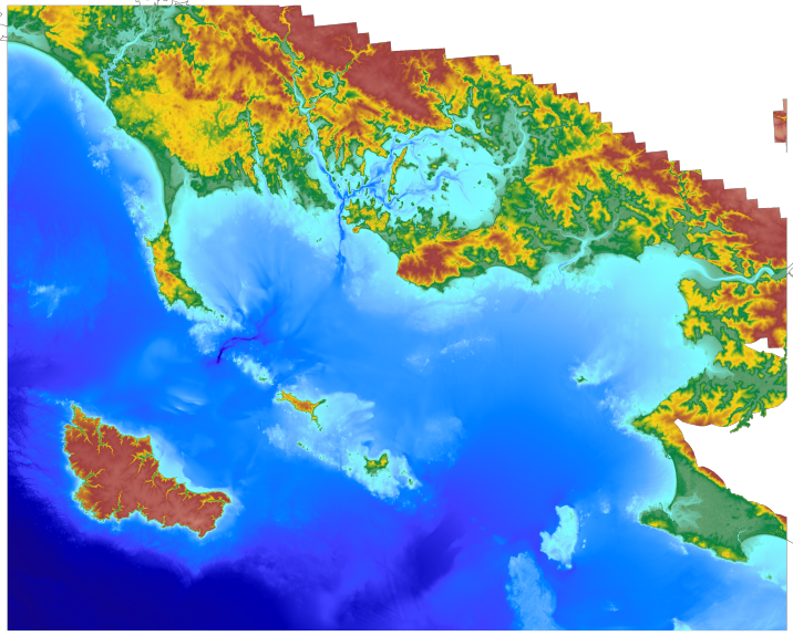
The coastal topo-bathymetric DEM of Moorea with a resolution of 0.0002° (~ 20 m) was produced by the Shom for Météo-France (Inter-regional Direction in French Polynesia). This DEM covers the Moorea lagoons down to the 100 m isobath, in order to meet the need for modeling marine submersions in French Polynesia. It complements the bathymetric DEM of Tahiti and Moorea, with a resolution of 0.001° (~ 100 m). The vertical reference for this product is the Lowest Astronomical Tide (LAT).
-
Le produit bathymétrie de façade Corse d'une résolution de 0.001° (~ 111 m) a été réalisé dans le cadre du projet HOMONIM. Il couvre l’intégralité de la marge Corse, du littoral jusqu’à environ 3000 m de profondeur. Le MNT est destiné à être implémenté dans les modèles hydrodynamiques afin de produire des prévisions aussi précises que possible des hauteurs d’eau et d’états de mer à la côte et donc d’améliorer la pertinence de la Vigilance Vagues-Submersion. La référence verticale de ce produit est le niveau moyen des mers.
-
Le produit bathymétrie de façade golfe du Lion – Côte d’Azur d'une résolution de 0.001° (~ 111 m) a été réalisé dans le cadre du projet HOMONIM. Il couvre l’intégralité de la façade métropolitaine méditerranéenne, du littoral jusqu’à environ 2800 m de profondeur. Le MNT est destiné à être implémenté dans les modèles hydrodynamiques afin de produire des prévisions aussi précises que possible des hauteurs d’eau et d’états de mer à la côte et donc d’améliorer la pertinence de la Vigilance Vagues-Submersion. La référence verticale de ce produit est le niveau des plus basses mers astronomiques.
-
Le MNT topo-bathymétrique côtier d'une partie du golfe normand-breton à une résolution de 0.0002° (~ 20 m) a été réalisé dans le cadre du PAPI Saint-Malo. Le MNT englobe le plateau des Minquiers au Nord-Ouest jusqu'à la baie du Mont-Saint-Michel au Sud-Est. Le MNT est destiné à être implémenté dans les modèles hydrodynamiques afin de produire des prévisions aussi précises que possible des hauteurs d’eau et d’états de mer à la côte et donc d’améliorer la gestion du risque de submersion marine.
-
Le produit topo-bathymétrique côtier de la baie de Saint-Jean-de-Luz et ses abords, à une resolution de 0.0002° (~20 m), a été réalisé dans le cadre du projet TANDEM. Il couvre un territoire comprenant la baie de Saint-Jean-de-Luz et ses abords immediats. Ce MNT est destiné à être implémenté dans les modèles hydrodynamiques du projet TANDEM afin d'estimer les effets côtiers des tsunamis pour l’Atlantique et la Manche, où sont installées les centrales nucléaires françaises depuis environ 30 ans. La référence verticale de ce produit est le niveau moyen des mers.
-
Le produit topo-bathymétrique côtier de la zone "Morbihan" à une résolution de 0.0002° (~20 m) a été réalisé dans le cadre du projet TANDEM (Programme Investissements d'Avenir, ANR-11-RSNR-00023-01). Il couvre un secteur en-globant majoritairement le département du Morbihan et une partie de celui de la Loire-Atlantique. Ce MNT s’étend de la presqu'île de Gâvres au nord-ouest jusqu'à La Baule au sud-est, il englobe le golfe du Morbihan, la baie et la presqu'île de Quiberon, les îles d'Houat, Hoëdic et Belle-Ile, l'estuaire de la Vilaine… Ce MNT est destiné à être implémenté dans les modèles hydrodynamiques du projet TANDEM afin d'estimer les effets côtiers des tsunamis pour l’Atlantique et la Manche, où sont installées les centrales nucléaires françaises depuis environ 30 ans. La référence verticale de ce produit est le niveau des plus basses mers astronomiques.
-

Le MNT bathymétrique de façade de Saint-Martin et Saint-Barthélemy à une résolution de 0.001° (~ 100 m) a été réalisé dans le cadre du projet HOMONIM. Le MNT englobe une partie des îles des petites Antilles, depuis Anguilla au nord jusqu’à Saba au sud. Il s’étend au large jusqu’à 3275 m de profondeur. Le MNT est destiné à être implémenté dans les modèles hydrodynamiques afin de produire des prévisions aussi précises que possible des hauteurs d’eau et d’états de mer à la côte et donc d’améliorer la pertinence de la Vigilance Vagues-Submersion.
-
Le MNT bathymétrique de façade Atlantique à une résolution de 0.001° (~ 111 m) a été réalisé dans le cadre du projet HOMONIM. Il englobe une partie de Mer du Nord, la Manche ainsi que le Golfe de Gascogne. Au large, ce MNT s’étend au-delà du talus jusqu’à environ 4800 m de profondeur. Le MNT est destiné à être implémenté dans les modèles hydrodynamiques afin de produire des prévisions aussi précises que possible des hauteurs d’eau et d’états de mer à la côte et donc d’améliorer la pertinence de la Vigilance Vagues-Submersion. Ce produit est disponible avec comme référence verticale le niveau des plus basses mers astronomiques (PBMA) ou le niveau moyen des mers (NM).
-

The coastal topo- bathymetric DEM of a part of the Norman-Breton gulf with a resolution of 0.0002° (~ 20 m) was prepared as part of the PAPI Saint-Malo. It covers the Minquiers plateau in the north-west to the bay of Mont-Saint-Michel in the south-east. The DEM is designed to be implemented in the hydrodynamic models of the TANDEM project in order to estimate the coastal effects of tsunamis for the Atlantic and English Channel, where French nuclear power plants have been installed for about 30 years. This product is available with the Lowest Astronomic Tide (LAT) or the Mean Sea Level (MSL) as a vertical datum.
-
The coastal topo- bathymetric DEM for the coasts of Morbihan with a resolution of 0.0002° (~ 20 m) was prepared as part of the TANDEM project (Programme Investissements d'Avenir, ANR-11-RSNR-00023-01). It covers the French administrative department of Morbihan and part of Loire-Atlantique. This DEM runs from the Gâvres peninsula in the north west to La Baule in the south east and covers the Gulf of Morbihan, the Quiberon bay and peninsula, Houat, Hoëdic and Belle-Ile islands and the Vilaine estuary. The DEM is designed to be implemented in the hydrodynamic models of the TANDEM project in order to estimate the coastal effects of tsunamis for the Atlantic and English Channel, where French nuclear power plants have been installed for about 30 years. This product is available with the Lowest Astronomic Tide (LAT) or the Mean Sea Level (MSL) as a vertical datum.