 Catalogue Shom
GLZ
Type of resources
Available actions
Topics
Provided by
Years
Formats
Representation types
Update frequencies
status
Scale
Resolution
-
Modèle bathymétrique (MNT) à 100m de résolution de la ZPE de Méditerranée.
-
Modèle bathymétrique (MNT) à 100m de résolution de la façade maritime française de la Méditerranée de 0 à 50m de profondeur (ou 40km des côtes). La modélisation a été effectuée en 2010.
-
The coastal topo-bathymetric DEM of Moorea with a resolution of 0.0002° (~ 20 m) was produced by the Shom for Météo-France (Inter-regional Direction in French Polynesia). This DEM covers the Moorea lagoons down to the 100 m isobath, in order to meet the need for modeling marine submersions in French Polynesia. It complements the bathymetric DEM of Tahiti and Moorea, with a resolution of 0.001° (~ 100 m). The vertical reference for this product is the Lowest Astronomical Tide (LAT).
-
Le produit bathymétrie de façade Corse d'une résolution de 0.001° (~ 111 m) a été réalisé dans le cadre du projet HOMONIM. Il couvre l’intégralité de la marge Corse, du littoral jusqu’à environ 3000 m de profondeur. Le MNT est destiné à être implémenté dans les modèles hydrodynamiques afin de produire des prévisions aussi précises que possible des hauteurs d’eau et d’états de mer à la côte et donc d’améliorer la pertinence de la Vigilance Vagues-Submersion. La référence verticale de ce produit est le niveau moyen des mers.
-
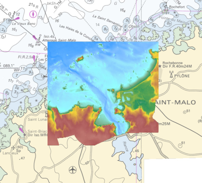
The coastal topo- bathymetric DEM of the port of Saint-Malo and its surroundings with a resolution of 0.00005° (~ 5 m) was prepared as part of the PAPI Saint-Malo. It covers the city of Saint-Malo and its surroundings, from the tip of Décollé in the west to the tip of Varde in the east. The DEM is designed to be implemented in the hydrodynamic models of the TANDEM project in order to estimate the coastal effects of tsunamis for the Atlantic and English Channel, where French nuclear power plants have been installed for about 30 years. This product is available with the Lowest Astronomic Tide (LAT) or the Mean Sea Level (MSL) as a vertical datum.
-
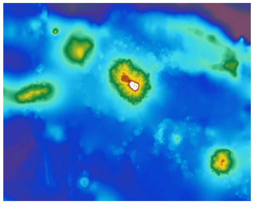
The bathymetric DEM was produced using the bathymetric and topographic data acquired between 2012 and 2015 by Shom and the PASSION programme team. The extent of the 100 m coastal grid covers an extended area around Passion Island – Clipperton, Mount Queiros, Mount Cermeno, and adjacent shallow waters. Passion island - Clipperton, in the eastern Pacific Ocean, is a remote uninhabited atoll over 5,000 km from Tahiti in French Polynesia and over 1,000 km from the Mexican coasts. Passion island is the highest point on the Clipperton ridge, and the only location above water level. This is the only coral atoll in the eastern Pacific in the northern hemisphere, at a longitude of W 109° and a latitude of N 10°.
-
The coastal topo-bathymetric DEM of Tahiti with a resolution of 0.0002° (~ 20 m) was produced by the Shom for Météo-France (Inter-regional Direction in French Polynesia). This DEM covers the Tahiti lagoons down to the 100 m isobath, in order to meet the need for modeling marine submersions in French Polynesia. It complements the bathymetric DEM of Tahiti and Moorea, with a resolution of 0.001° (~ 100 m). The vertical reference for this product is the Lowest Astronomical Tide (LAT).
-

The coastal topo-bathymetric DTM of the Arcachon basin and its surroundings at a resolution of 0.0002° (~ 20 m) was produced as part of the HOMONIM project. The DTM covers the coastline of a part of the Gironde department, from the Carcans and Hourtin ponds in the North, to the Cazaux and Sanguinet lakes in the South. It covers the entire Arcachon basin and extends offshore to about 40 m depth. The DTM is intended to be implemented in hydrodynamic models in order to produce accurate forecasts of water heights and sea states at the coast and to improve the French storm surge warning system. This product is available with the Lowest Astronomic Tide (LAT) or with the Mean Sea Level (MSL) as a vertical datum.
-
Le MNT bathymétrique de façade de la Guyane, à une résolution de 0.001° (~ 111 m), a été réalisé dans le cadre du projet HOMONIM. Il couvre intégralement la côte Guyanaise et s'étend en partie sur le Suriname à l'Ouest et le Bresil à l'Est. Au large, le MNT englobe le plateau continental ainsi qu'une partie du talus. Le MNT est destiné à être implémenté dans les modèles hydrodynamiques afin de produire des prévisions aussi précises que possible des hauteurs d’eau. La référence verticale de ce produit est le niveau moyen des mers.
-
The bathymetric DEM of Tahiti and Moorea with a resolution of 0.001° (~ 100 m) was produced by the Shom for Météo-France (Inter-regional Direction in French Polynesia). This DEM covers a 10 km radius around the islands of Tahiti and Moorea in order to meet the need for marine submersions modelling in French Polynesia. The vertical reference for this product is the Lowest Astronomical Tide (LAT).