Catalogue Shom
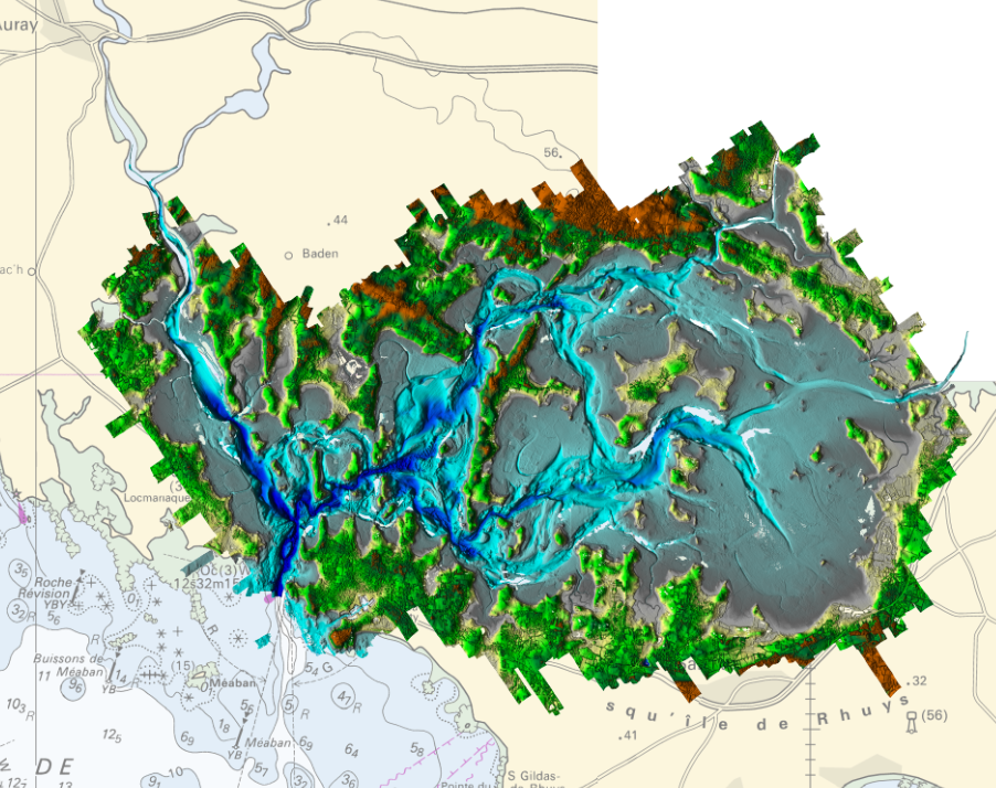
LITTO3D® marine part Morbihan 2015
Litto3D Marine Part is an intermediate product of the Litto3D product containing only marine data.Litto3D is a unique and continuous land-sea database which can provide 3D models of the shape and location of French coastal terrain. A line separates sea and land data acquisition zones, and the associated survey readings obtained using bathymetric lidar technologies or multibeam echosounders for sea readings and airborne lidar topographical surveys for land readings, with 300 m overlap. Litto3D digital models are available in two formats: a set of 3D points and a qualified terrain mesh.
|
|
Citation proposal
(2015) . LITTO3D® marine part Morbihan 2015. https://services.data.shom.fr:/geonetwork/telechargement/api/records/BATHYMETRIE_L3D_MAR_MORBIHAN_2015.xml |
Simple
- Alternate title
-
Land-sea altimetric database
- Date ( Publication )
- 2015-05-19
- Edition
-
Edition 1.0
- Presentation form
- Digital map
- Purpose
-
The main aim is to produce precise digital data with unrivalled resolution (decimetric precision, metric resolution) for French coastal terrain. This solution provides the basic data required to implement many applications and public policies, such as:
• Risk prevention (tsunamis, cyclone swell, rising sea level due to global warming, coastal flooding, flooding, erosion, etc.),
• Coastal planning studies (roads, ports, etc.),
• improved knowledge of the public maritime territory, tracking coastal withdrawal,
• mapping terrestrial and marine habitats,
• creating current models and related applications (tidal and swell current energy, waste dispersal at sea, sedimentary movements, etc.)
• Integrated Coastal Zone Management (ICZM).
- Credit
-
The topo-bathymetric data acquired by airborne lidar as part of a demonstrator made by the Shom on the Gulf of Morbihan in 2005 and re-processed with an algorithm (after 2010) for detection of bottoms in thin-layer zone water and in turbid waters are the product "marine part" Litto3D® Gulf of Morbihan.
The bathymetric data were supplemented by Shom and Ifremer multibeam echosounder (SMF) surveys available in the area.
Litto3D® "marine part" Gulf of Morbihan V.20150519 covers a geographical area extending from its mouth to Arzon to Vannes, via Auray and Sarzeau
Originator
- Maintenance and update frequency
- Irregular
- Keywords ( Theme )
-
-
Product
-
open data
-
- Use limitation
-
The product is distributed under an Opendata license (version 2.0, April 2017), defined by the Etalab mission.
- Use limitation
-
Data may be freely used providing that the source.
- Use limitation
-
Do not use for navigation
- Use limitation
-
The product is distributed under an Opendata license (version 2.0, April 2017), defined by the Etalab mission.
- Access constraints
- License
- Use constraints
- Other restrictions
- Other constraints
-
No public restriction.
- Classification
- Unclassified
- Spatial representation type
- Grid
- Distance
- 5 m
- Metadata language
- fre French
- Character set
- utf8 UTF8
- Topic category
-
- Elevation
- Description
-
MORBIHAN
))
- Reference system identifier
-
EPSG
/RGF93 / Lambert-93 (EPSG:2154)
/7.4
- Distribution format
-
-
ASC
(-
) -
XYZ
(-
)
-
Point of contact
- OnLine resource
- Shom geoportal
- OnLine resource
-
L3D_MAR_MORBIHAN_2015_PYR_3857_WMSR
LITTO3D® marine part Morbihan 2015
- OnLine resource
- Download service
- OnLine resource
- Shom distribution space
- Hierarchy level
- Series
Conformance result
- Date ( Publication )
- 2010-11-23
- Explanation
-
Information sur la conformité au règlement d'interopérabilité des séries et des services de données géographiques.
Conformité non évaluée.
- Pass
- false
- Statement
-
These bathymetric and topographic data have been acquired:
- For the Shom Litto3D® demonstrator by airborne lidar: around the average date of June 15, 2005
- For the Shom multibeam echosounder (SMF): around the average date of December 1, 2003
- For Ifremer SMF : around the average date of October 1, 2013.
- For Shom's Litto3D® demonstrator, bathymetric and topographic data come from an Optech Shoals 1000T sensor.
- The bathymetric data provided in addition come from multibeam sensors (Shom or Ifremer shallows). These data generally respect the order 1b of the PS44
gmd:MD_Metadata
- File identifier
- BATHYMETRIE_L3D_MAR_MORBIHAN_2015.xml XML
- Metadata language
- fre French
- Character set
- UTF8
- Hierarchy level
- Series
- Hierarchy level name
-
Collection de données
- Date stamp
- 2023-06-29T11:15:08
- Metadata standard name
-
ISO 19115:2003/19139
- Metadata standard version
-
1.0
Point of contact
Overviews
Provided by