 Catalogue Shom
boundaries
Type of resources
Available actions
Topics
Keywords
Contact for the resource
Provided by
Years
Formats
Representation types
Update frequencies
Scale
-
Compilation of marine gravity surveys acquired in the Northeast Atlantic by Shom between 2001 and 2016. These surveys were compiled to perform a quantification of the error of the gravity anomaly models derived from satellite altimetry. This dataset represents more than 22,000 measurement points distributed in 9 ascii survey files sampled at 1 kilometer. The file’s format is as follows: longitude latitude Gravity_anomaly error line_label.
-
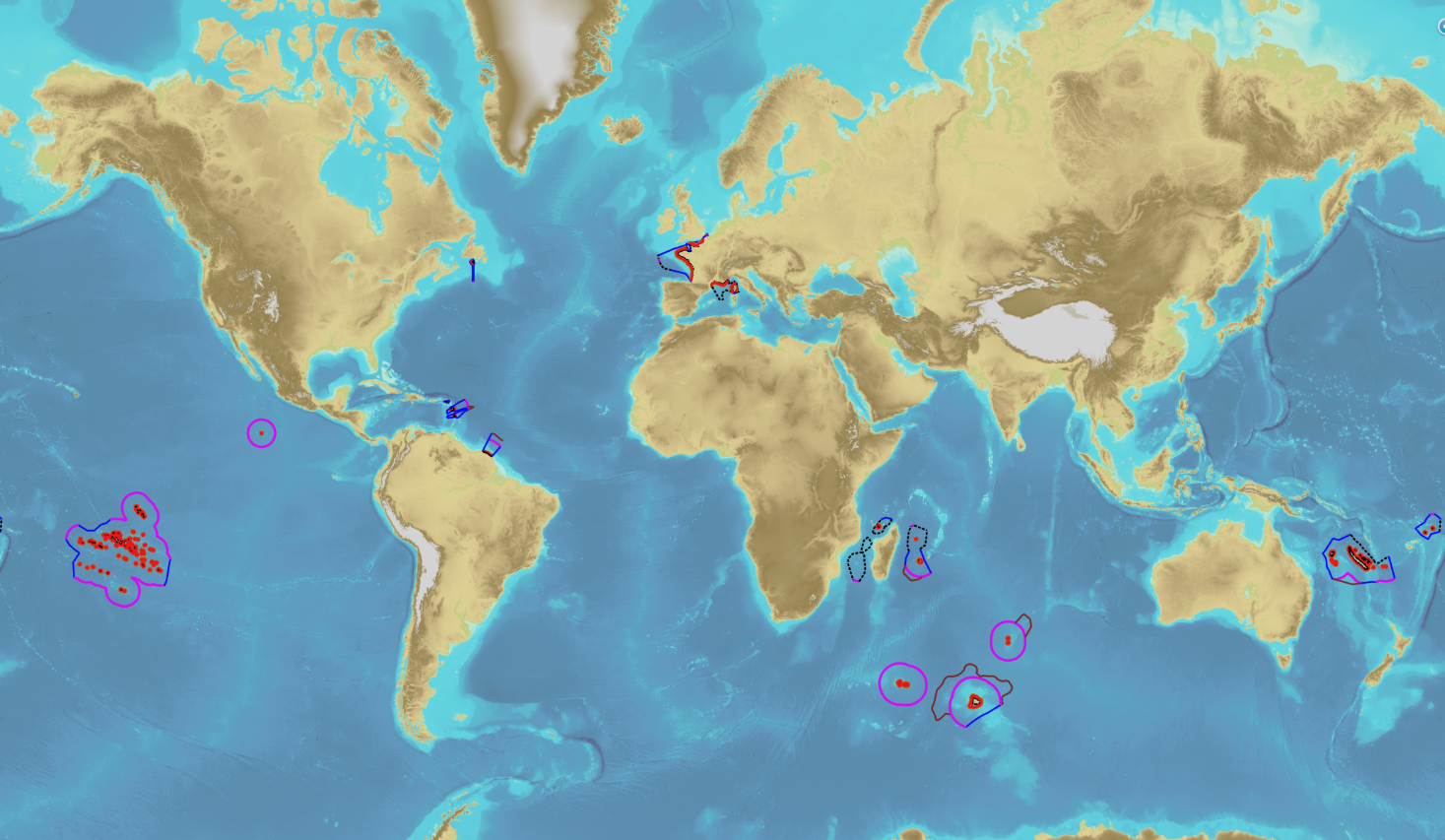
The product “Maritime limits and boundaries” (French: “Délimitations maritimes”) gathers all the elements used for the definition of the maritime spaces under the French sovereignty or jurisdiction through the world. Those spaces are defined by the Ordonnance n° 2016-1687 of 8 December 2016 relating to maritime spaces under sovereignty or jurisdiction of the French Republic. This ordonnance is the transcription in the French legislation of the United Nations Convention on the Law of the Sea (UNCLOS) which was signed in Montego Bay (Jamaica) on 10 December 1982 end ratified by France on 11 April 1996. These elements of maritime limits and boundaries come from the limits computed by Shom on the basis of International Law, from the international agreements relating to maritime boundary and the technical conventions ratified between France and other States, from the decisions of international juridical bodies, from the recommendations of the Commission of the Limits of the Continental Shelf (UNO) or from unilateral claims from France in the absence of agreement. The elements are divided into seven themes: 1- Straight baselines 2- Outer limits of the territorial sea (12 nautical miles) 3- Outer limits of the contiguous zone (24 nautical miles) 4- Outer limits of the exclusive economic zone (200 nautical miles) 5- Maritime boundaries established by a bilateral agreement or decided by an international juridical body 6- Maritime boundaries unilaterally claimed by France in the absence of agreement 7- Outer limit of the continental shelf beyond 200 nautical miles December 2022 version
-
In compliance with Article 33 of UNCLOS, the outer limit of the contiguous zone is located at 24 nautical miles from the baselines. The objects of the theme "Outer limit of the contiguous zone" result from Shom computations and are compliant with Article 10 of the French Order No 2016-1687 of 8 December 2016.
-

The "Sovereignty and jurisdiction maritime spaces of France" product contains the areas of sovereignty and jurisdiction maritime spaces of France all around the world.<br /><br /> It is constituted of 2D areas objects split into four categories :<br /> - the territorial sea (from baselines to a distance of 12 nautical miles or to maritime boundaries with neighbouring countries);<br /> - the contiguous zone (from 12 nautical miles to 24 nautical miles from the baselines or to maritime boundaries with neighbouring countries);<br /> - the exclusive economic zone (EEZ) (from 12 nautical miles to 200 nautical miles from the baselines or to maritime boundaries with neighbouring countries);<br /> - the continental shelf over the 200 nautical miles limit (from 200 nautical miles from the baselines to the limits recommended by the Commission on the Limits of the Continental Shelf (CLCS) or to the maritime boundaries with neighbouring countries).<br /> Internal waters, which constitute a space of sovereignty beyond the baselines, are not included in the "Sovereignty and jurisdiction maritime spaces of France" product.<br /> The "Sovereignty and jurisdiction maritime spaces of France" product may not be considered as an enforceable right. Only the “Maritime limits and boundaries” product, that can be displayed and interrogated on the website data.shom.fr (maritime boundaries category) and also downloaded on the French national portal of maritime limits (https://maritimelimits.gouv.fr), may be considered so.<br /><br /> December 2022 version.
-

Information layer containing the SAR Zones (Search and Rescue). This layer contains a description of the French search and rescue (SAR) areas and the location of the associated Maritime Rescue Coordination Center (MRCC). it covers the areas of responsibility of France. The layer was produced by the Shom pursuant to the Circular Circular of the International Maritime Organization (IMO No. SAR.8 / Circ.4 of 1 December 2012).
-
The territorial sea extends from the baselines to a maximum distance of 12 nautical miles, calculated from the baselines. The State has full sovereignty over the bed and subsoil, surface and underlying water column and air space. Sovereignty shall not, however, hinder the right of innocent passage of which the ships of all States benefit in the territorial sea.
-
The contiguous zone is adjacent to the territorial sea and may not extend beyond 24 nautical miles from the baselines from which the breadth of the territorial sea is measured. The coastal State may exercise the control necessary to: - prevent infringement of its customs, fiscal, immigration or sanitary laws and regulations within its territory or territorial sea; - punish infringement of the above laws and regulations committed within its territory or territorial sea.
-
In compliance with Article 3 of UNCLOS, the outer limit of the territorial sea is located at 12 nautical miles from the baselines. It corresponds to the inner limit of the contiguous and exclusive economic zones. The objects of the theme "Outer limit of the territorial sea" result from Shom computations and are published by decree of the French Republic. Some of those limits are note published by decree yet.
-
The exclusive economic zone is adjacent to the territorial sea and extends to a maximum distance of 200 nautical miles calculated from the baselines. This is a space in which the coastal State do not practice its entire sovereignty but only the following rights: - sovereign rights over the water column, the bed and subsoil for the purposes of: - exploration, exploitation, conservation and management of natural resources, whether biological or not; - exploration and exploitation of the zone for economic purposes, such as the production of energy from water, currents and wind; - jurisdiction concerning the following fields: - construction and use of artificial islands, facilities and works; - marine scientific research; - protection and preservation of the marine environment. Apart from the rights and obligations of the coastal States cited above, the exclusive economic zone is a space open to the exercise by any other State of the freedoms set down in the United Nations Convention on the law of the sea (UNCLOS) (navigation, overflight, etc.), within the limits set by the Convention.
-
The combined error grid of the SIO V31 gravity anomaly model (D. T. Sandwell, H. Harper, B. Tozer et al., Gravity field recovery from geodetic altimeter missions, Advances in Space Research, https://doi.org/10.1016/j.asr.2019.09.011) is computed with a method described in a paper submitted to Earth and Space Science (AGU). The model’s extension is North Atlantic.