 Catalogue Shom
0.0002 dd
Type of resources
Available actions
Topics
Provided by
Years
Formats
Representation types
Update frequencies
status
Resolution
-
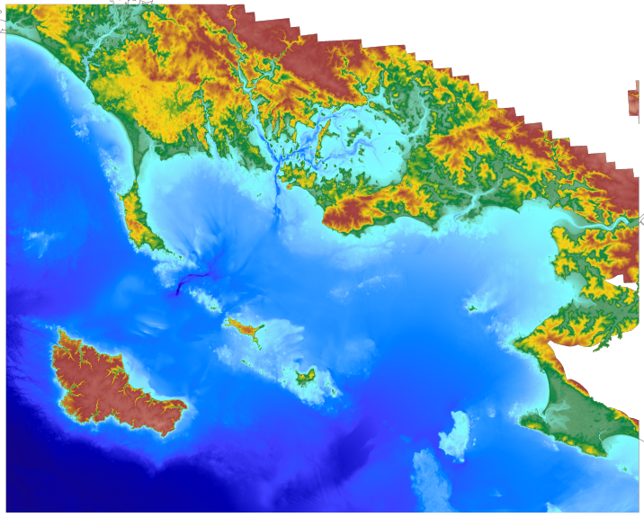
Le produit topo-bathymetrique côtier du détroit du Pas-de-Calais à une resolution de 0.0002° (~20 m) a été réalisé dans le cadre du projet TANDEM. Ce MNT côtier s'étend sur un territoire entre manche orientale et Mer du Nord meridionale, comprenant le littoral français du Nord - Pas-de-Calais ainsi qu'une partie du littoral britannique, dans le comté du Kent, du sud de l'estuaire de la Tamise jusqu'à Rye. Ce MNT est destiné à être implémenté dans les modèles hydrodynamiques du projet TANDEM afin d'estimer les effets côtiers des tsunamis pour l’Atlantique et la Manche, où sont installées les centrales nucléaires françaises depuis environ 30 ans.
-
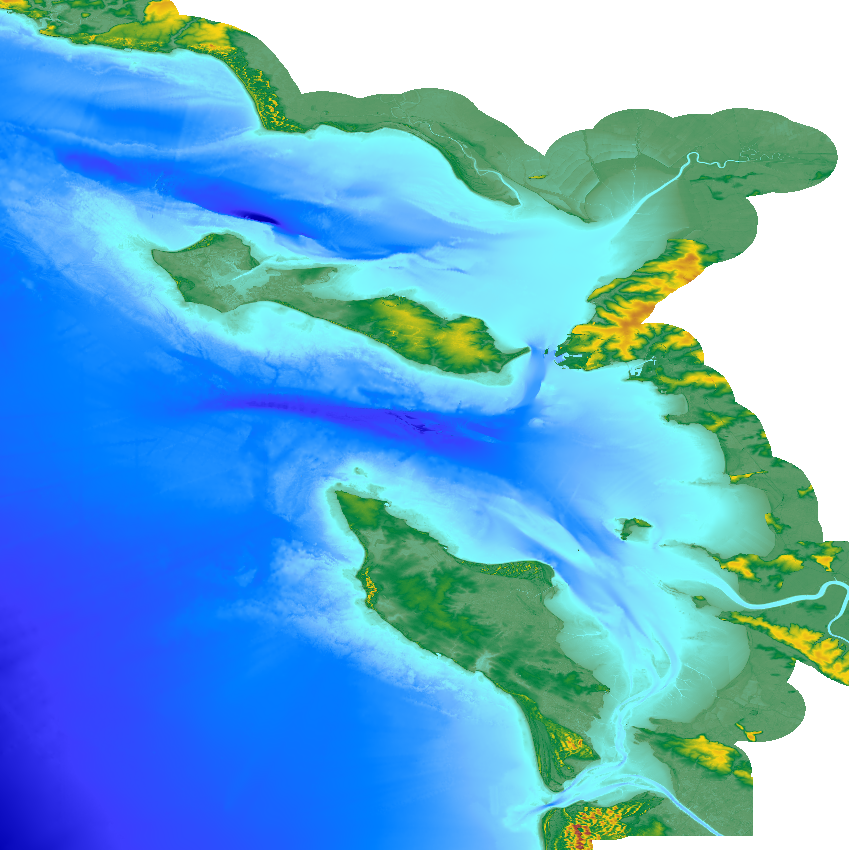
Le produit topo-bathymétrique côtier de la zone "Morbihan" à une résolution de 0.0002° (~20 m) a été réalisé dans le cadre du projet TANDEM (Programme Investissements d'Avenir, ANR-11-RSNR-00023-01). Il couvre un secteur en-globant majoritairement le département du Morbihan et une partie de celui de la Loire-Atlantique. Ce MNT s’étend de la presqu'île de Gâvres au nord-ouest jusqu'à La Baule au sud-est, il englobe le golfe du Morbihan, la baie et la presqu'île de Quiberon, les îles d'Houat, Hoëdic et Belle-Ile, l'estuaire de la Vilaine… Ce MNT est destiné à être implémenté dans les modèles hydrodynamiques du projet TANDEM afin d'estimer les effets côtiers des tsunamis pour l’Atlantique et la Manche, où sont installées les centrales nucléaires françaises depuis environ 30 ans. La référence verticale de ce produit est le niveau des plus basses mers astronomiques.
-
The coastal topo- bathymetric DEM for the coasts of Morbihan with a resolution of 0.0002° (~ 20 m) was prepared as part of the TANDEM project (Programme Investissements d'Avenir, ANR-11-RSNR-00023-01). It covers the French administrative department of Morbihan and part of Loire-Atlantique. This DEM runs from the Gâvres peninsula in the north west to La Baule in the south east and covers the Gulf of Morbihan, the Quiberon bay and peninsula, Houat, Hoëdic and Belle-Ile islands and the Vilaine estuary. The DEM is designed to be implemented in the hydrodynamic models of the TANDEM project in order to estimate the coastal effects of tsunamis for the Atlantic and English Channel, where French nuclear power plants have been installed for about 30 years. This product is available with the Lowest Astronomic Tide (LAT) or the Mean Sea Level (MSL) as a vertical datum.
-
Le produit topo-bathymetrique côtier de l'estuaire de la Gironde a une resolution de 0.0002° (~20 m) a été réalisé dans le cadre du projet TANDEM. Il s'étend sur un territoire situé autour de l'estuaire de la Gironde, de son embouchure en Atlantique jusqu'à Bordeaux (sur la Garonne) et Libourne (sur la Dordogne). Le MNT est realisé sous la forme de deux boites d'emprises complementaires : 1) Estuaire aval (de l'embouchure de la Gironde à Pauillac) ; 2) Estuaire amont (de Pauillac jusqu'a Bordeaux sur la Garonne, et jusqu'à Libourne sur la Dordogne). Ce MNT est destiné à être implémenté dans les modèles hydrodynamiques du projet TANDEM afin d'estimer les effets côtiers des tsunamis pour l’Atlantique et la Manche, où sont installées les centrales nucléaires françaises depuis environ 30 ans.
-

The coastal topo- bathymetric DEM of a part of the Norman-Breton gulf with a resolution of 0.0002° (~ 20 m) was prepared as part of the PAPI Saint-Malo. It covers the Minquiers plateau in the north-west to the bay of Mont-Saint-Michel in the south-east. The DEM is designed to be implemented in the hydrodynamic models of the TANDEM project in order to estimate the coastal effects of tsunamis for the Atlantic and English Channel, where French nuclear power plants have been installed for about 30 years. This product is available with the Lowest Astronomic Tide (LAT) or the Mean Sea Level (MSL) as a vertical datum.
-
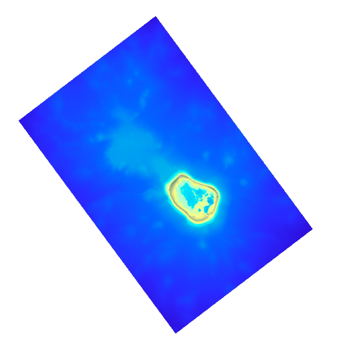
Le MNT topo-bathymétrique côtier de l'Île de La Passion – Clipperton à une résolution de 20 m a été réalisé en valorisant les données bathymétriques et topographiques acquises entre 2012 et 2015 par le Shom et l'équipe du programme PASSION. La grille côtière à 20 m comprend l'atoll de La Passion – Clipperton et ses flancs immédiats jusqu'à environ 1500 m de profondeur. L'Île de La Passion - Clipperton, située dans l'Océan pacifique Est, est un atoll inhabité isolé à plus de 5000 km de Tahiti en Polynésie Française et plus de 1000 km des côtes mexicaines. L'île est le point culminant, et le seul émergé, de la dorsale de Clipperton. Il s'agit du seul atoll corallien du Pacifique oriental situé dans l'hémisphère nord, par 109°de longitude Ouest et 10° de latitude Nord.
-
The update of the coastal topo-bathymetric DEM of the Pertuis charentais at a resolution of 0.0002° (~ 20 m) was carried out in the third phase of the HOMONIM project. The DEM extends from the terrestrial domain to about 60 meters depth over all the pertuis (pertuis Breton, pertuis d’Antioche and pertuis of Maumusson). The DEM is intended to be implemented in hydrodynamic models in order to produce forecasts as accurate as possible of water heights and sea states at the coast to improve the relevance of the Wave-Submergence Vigilance. This product is available with either the Lowest Astronomic Tide (LAT) or the Mean Sea Level (MSL) as a vertical reference.
-
Le MNT topo-bathymétrique côtier d'une partie du golfe normand-breton à une résolution de 0.0002° (~ 20 m) a été réalisé dans le cadre du PAPI Saint-Malo. Le MNT englobe le plateau des Minquiers au Nord-Ouest jusqu'à la baie du Mont-Saint-Michel au Sud-Est. Le MNT est destiné à être implémenté dans les modèles hydrodynamiques afin de produire des prévisions aussi précises que possible des hauteurs d’eau et d’états de mer à la côte et donc d’améliorer la gestion du risque de submersion marine.
-
Le produit topo-bathymetrique côtier de l'estuaire de la Gironde a une resolution de 0.0002° (~20 m) a été réalisé dans le cadre du projet TANDEM. Il s'étend sur un territoire situé autour de l'estuaire de la Gironde, de son embouchure en Atlantique jusqu'à Bordeaux (sur la Garonne) et Libourne (sur la Dordogne). Le MNT est realisé sous la forme de deux boites d'emprises complementaires : 1) Estuaire aval (de l'embouchure de la Gironde à Pauillac) ; 2) Estuaire amont (de Pauillac jusqu'a Bordeaux sur la Garonne, et jusqu'à Libourne sur la Dordogne). Ce MNT est destiné à être implémenté dans les modèles hydrodynamiques du projet TANDEM afin d'estimer les effets côtiers des tsunamis pour l’Atlantique et la Manche, où sont installées les centrales nucléaires françaises depuis environ 30 ans.
-
The coastal topo-bathymetric DEM was produced using the bathymetric and topographic data acquired between 2012 and 2015 by Shom and the PASSION programme team. The 20 m coastal grid covers the Passion atoll – Clipperton and the local flanks of the atoll to a depth of 1500 m. Passion island - Clipperton, in the eastern Pacific Ocean, is a remote uninhabited atoll over 5,000 km from Tahiti in French Polynesia and over 1,000 km from the Mexican coasts. Passion island is the highest point on the Clipperton ridge, and the only location above water level. This is the only coral atoll in the eastern Pacific in the northern hemisphere, at a longitude of W 109° and a latitude of N 10°.