 Catalogue Shom
glhi
Type of resources
Available actions
Topics
Provided by
Formats
Representation types
-
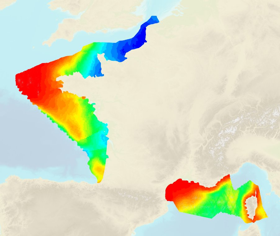
La surface BathyElli v2.0 ZH est une réalisation de la hauteur ellipsoïdale du Zéro Hydrographique. Le Zéro Hydrographique réalisé par la surface BathyElli v2.0 ZH est exprimé à la date de référence du 2000/01/01. L’évolution de la réalisation du Zéro Hydrographique par la surface BathyElli v2.0 ZH est inférieure à 3 mm/an en valeur absolue. Pour des applications ne nécessitant pas une incertitude meilleure que quelques centimètres sur la verticale, aucun changement d’époque n’est nécessaire. Le Zéro Hydrographique réalisé par la surface BathyElli v2.0 ZH est exprimé par sa hauteur ellipsoïdale dans le repère géodésique légal conformément aux décrets n°2000-1276 et 2006-272. Pour la France métropolitaine le repère géodésique légal est RGF93 et l'ellipsoïde associé GRS80. L’écart entre le RGF93 et la dernière réalisation de l’ITRS ou la dernière réalisation du WGS84 est inférieur à quelques mètres. Pour des applications ne nécessitant pas une incertitude meilleure que quelques mètres sur l’horizontale, aucun changement de réalisation de système géodésique n’est nécessaire. La surface couvre les zones de marée de France métropolitaine.
-
Le projet du SHOM intitulé BATHYELLI (acronyme de « Bathymétrie rapportée à l’ellipsoïde ») a généré les modèles surfaciques des références verticales maritimes suivantes, cotées par rapport à l’ellipsoïde IAG GRS80, associé au système géodésique légal RGF93 : - Niveau Moyen (NM) des mers, - Niveau des Plus Basses Mers Astronomiques (PBMA), - Niveau des Plus Hautes Mers Astronomiques (PHMA), - Zéro Hydrographique (ZH). Le décret n° 2006-272 du 3 mars 2006 définit la mission du SHOM de "diffusion des cotes des Zéros Hydrographiques dans les systèmes de référence altimétriques légaux".
-

The product "BathyElli surfaces v2.1" contains the surface realisation of the ellipsoidal height at the reference date of 1 January 2000 of the characteristic tidal levels corresponding to : - Highest Astronomical Tide (HAT): "BathyElli v2.1 HAT / ell" ; - Mean Sea Levels (MSL): "BathyElli v2.1 MSL / ell"; - Lowest Astronomical Tide (LAT): "BathyElli v2.1 LAT / ell"; - Chart Datum (CD) vertical sea level reference for each tidal zone: "BathyElli v2.1 HZ / ell".
-
Etat des levés réalisés
-
Le projet du Shom intitulé BATHYELLI (acronyme de « Bathymétrie rapportée à l’ellipsoïde ») a généré les modèles surfaciques des références verticales maritimes suivantes, cotées par rapport à l’ellipsoïde IAG GRS80, associé au système géodésique légal RGF93 : - Niveau Moyen (NM) des mers, - Niveau des Plus Basses Mers Astronomiques (PBMA), - Niveau des Plus Hautes Mers Astronomiques (PHMA), - Zéro Hydrographique (ZH). Le décret n° 2006-272 du 3 mars 2006 définit la mission du Shom de "diffusion des cotes des Zéros Hydrographiques dans les systèmes de référence altimétriques légaux".
-
Le projet du SHOM intitulé BATHYELLI (acronyme de « Bathymétrie rapportée à l’ellipsoïde ») a généré les modèles surfaciques des références verticales maritimes suivantes, cotées par rapport à l’ellipsoïde IAG GRS80, associé au système géodésique légal RGF93 : - Niveau Moyen (NM) des mers, - Niveau des Plus Basses Mers Astronomiques (PBMA), - Niveau des Plus Hautes Mers Astronomiques (PHMA), - Zéro Hydrographique (ZH). Le décret n° 2006-272 du 3 mars 2006 définit la mission du SHOM de "diffusion des cotes des Zéros Hydrographiques dans les systèmes de référence altimétriques légaux".
-
The BathyElli v2.1 MSL surface is a realisation of the ellipsoidal height of the Mean Sea Level (MSL). The MSL realised by the BathyElli v2.1 MSL surface is expressed at the reference date of 2000/01/01. The evolution of the realisation of the MSL by the BathyElli v2.1 NM surface is less than 3 mm/year in absolute value. For applications that do not require an uncertainty better than a few centimetres on the vertical, no change of epoch is necessary. The MSL realised by the BathyElli v2.1 MSL surface is expressed by its ellipsoidal height in the legal geodetic datum according to the decrees n°2000-1276 and 2006-272. For metropolitan France, the legal geodetic datum is RGF93 v2 and the associated ellipsoid GRS80. The difference between RGF93 v2 and the latest realisation of ITRS or the latest realisation of WGS84 is less than a few meters. For applications that do not require an uncertainty of better than a few metres on the horizontal, no change of realisation of the geodetic system is necessary. This product covers the intersection between the Shom tidal model and the different tidal zones of metropolitan France.
-
The BathyElli v2.1 HAT surface is a realisation of the ellipsoidal height of the Highest Astronomical Tide (HAT). The HAT realised by the BathyElli v2.1 HAT surface is expressed at the reference date of 2000/01/01. The HAT realised by the BathyElli v2.1 HAT surface is expressed by its ellipsoidal height in the legal geodetic datum according to the decrees n°2000-1276 and 2006-272. For metropolitan France, the legal geodetic datum is RGF93 v2 and the associated ellipsoid GRS80. The difference between RGF93 v2 and the latest realisation of ITRS or the latest realisation of WGS84 is less than a few meters. For applications that do not require an uncertainty of better than a few metres on the horizontal, no change of realisation of the geodetic system is necessary. This product covers the intersection between the Shom tidal model and the different tidal zones of metropolitan France.
-
The BathyElli v2.1 LAT surface is a realisation of the ellipsoidal height of the Lowest Astronomical Tide (LAT). The LAT realised by the BathyElli v2.1 LAT surface is expressed at the reference date of 2000/01/01. The LAT realised by the BathyElli v2.1 LAT surface is expressed by its ellipsoidal height in the legal geodetic datum according to the decrees n°2000-1276 and 2006-272. For metropolitan France, the legal geodetic datum is RGF93 v2 and the associated ellipsoid GRS80. The difference between RGF93 v2 and the latest realisation of ITRS or the latest realisation of WGS84 is less than a few meters. For applications that do not require an uncertainty of better than a few metres on the horizontal, no change of realisation of the geodetic system is necessary. This product covers the intersection between the Shom tidal model and the different tidal zones of metropolitan France.
-
The BathyElli v2.1 HZ surface is a realisation of the ellipsoidal height of the Hydrographic Zero (Chart Datum). The Hydrographic Zero realised by the BathyElli v2.1 HZ surface is expressed at the reference date of 2000/01/01. The evolution of the realisation of the Hydrographic Zero by the BathyElli v2.1 HZ surface is less than 3 mm/year in absolute value. For applications that do not require an uncertainty better than a few centimetres on the vertical, no change of epoch is necessary. The Hydrographic Zero realised by the BathyElli v2.1 HZ surface is expressed by its ellipsoidal height in the legal geodetic datum according to the decrees n°2000-1276 and 2006-272. For metropolitan France, the legal geodetic datum is RGF93 v2 and the associated ellipsoid GRS80. The difference between RGF93 v2 and the latest realisation of ITRS or the latest realisation of WGS84 is less than a few meters. For applications that do not require an uncertainty of better than a few metres on the horizontal, no change of realisation of the geodetic system is necessary. This product covers the intersection between the Shom tidal model and the different tidal zones of metropolitan France.