Time series of turbidity
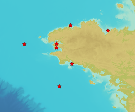
In early 2017, Shom established a near-bottom turbidity observation network to measure turbidity and currents near the seabed continuously, at high frequency and over a long period of time (several years). Seven mooring points with ecological and / or sedimentological interests and impacted by anthropogenic activities (except the control point in the Celtic Sea) have thus been defined. The product "Turbidity Time Series ROEC" contains turbidity level records measured in NTU by optical turbidimeters implanted at each of the 7 wetting points of the monitoring network. The data present in the product "ROEC Turbidity Time Series" corresponds to raw data from NTUS sensors (Wetlabs) deployed on different moorings and transcoded in .CSV format. The time series are provided in their entirety and have not been post-processed. The files can therefore include certain erroneous values related to specific anomalies in the acquisition made by the sensor or intervals without data when the acquisition knows ranges of interruption.
|
|
Citation proposal
(2019) . Time series of turbidity. https://services.data.shom.fr:/geonetwork/srv/api/records/ROEC_TURBI |
Simple
- Date ( Publication )
- 2019-05-24
- Identifier
Point of contact
- Keywords ( Theme )
-
-
sediment
-
turbidity
-
open data
-
- GEMET - INSPIRE themes, version 1.0 GEMET - INSPIRE themes, version 1.0 ( Theme )
-
-
Oceanographic geographical features
-
- Use limitation
-
Data may be freely used providing that the source is mentioned. https://doi.org/10.17183/roec_turbi
- Use limitation
-
Do not use for navigation
- Use limitation
-
The product is distributed under an Opendata license (version 2.0, April 2017), defined by the Etalab mission.
- Access constraints
- License
- Use constraints
- Other restrictions
- Other constraints
-
Data may be freely used providing that the source is mentioned. https://doi.org/10.17183/roec_turbi
- Classification
- Unclassified
- Spatial representation type
- Text, table
- Metadata language
- French
- Character set
- UTF8
- Topic category
-
- Oceans
))
- Reference system identifier
-
EPSG
/WGS 84 (EPSG:4326)
/7.9
- Distribution format
-
-
CSV
(-
)
-
Point of contact
- OnLine resource
- Shom geoportal
- OnLine resource
-
ROEC_TURBI_3857_WMSV
Mooring points ROEC Turbidity WMS
- Hierarchy level
- Series
Conformance result
- Date ( Publication )
- 2010-12-08
- Explanation
-
Information sur la conformité au règlement d'interopérabilité des séries et des services de données géographiques.
- Statement
-
The sensors used to monitor turbidity near the bottom are: NTUS Optical Turbidimeter (Wetlabs) and Aquadopp 200m Spot Current Meter (Nortek).
The optical turbidimeter gives a qualitative information of underwater visibility. It measures the absorbance and / or the diffusion of a light ray of known wavelength by a liquid. The incident light thus reflected towards the instrument is a function of the quantity of particles suspended in the water. Optical turbidimeters give values in NTU (Nephelometric Turbidity Unit) to assess the ability of water to let light (turbidity). The turbidimeters were chosen to measure at 650 nm, ie in the red. This criterion is important to consider because it means that it will be much more sensitive to mineral particles than to phytoplankton.
The punctual current meter (Aquadopp) gives information on the intensity and direction of currents near the bottom. It can also measure temperature and pressure. This sensor, in addition to serving as a turbidimeter feed, can provide elements on hydrodynamic conditions and affirm or deny the impact of currents on turbidity variations.
After calibration in the laboratory, these two sensors are then fixed on structures which can be of two types according to the depth of immersion:
- for shallow waters (St Brieuc, Morlaix, Freight, Douarnenez and Concarneau), tripod cages made of aluminum (light) welcoming the sensors, a Sonardyne LRT width, weighing and anchoring systems as well as floats;
- for large funds (Grande Vasière and Gino points), Antirion type cages fixed on a concrete ballast and which require a carrier for their deployment.
The sensors (turbidimeter and current meter) are positioned to measure less than 1 m from the bottom for turbidimeters and 2 m for current meters.
Deployed instruments acquire a measurement every 20 minutes continuously. This frequency of acquisition requires a rotation of the systems every three months to guarantee the autonomy of the batteries and thus the continuity of the measurements.
- Description
Metadata
- File identifier
- ROEC_TURBI XML
- Metadata language
- French
- Character set
- UTF8
- Hierarchy level
- Series
- Hierarchy level name
-
Jeu de données
- Date stamp
- 2022-07-22T12:00:49
- Metadata standard name
-
ISO 19115:2003/19139
- Metadata standard version
-
1.0
Point of contact
Overviews
Provided by
