 Catalogue Shom
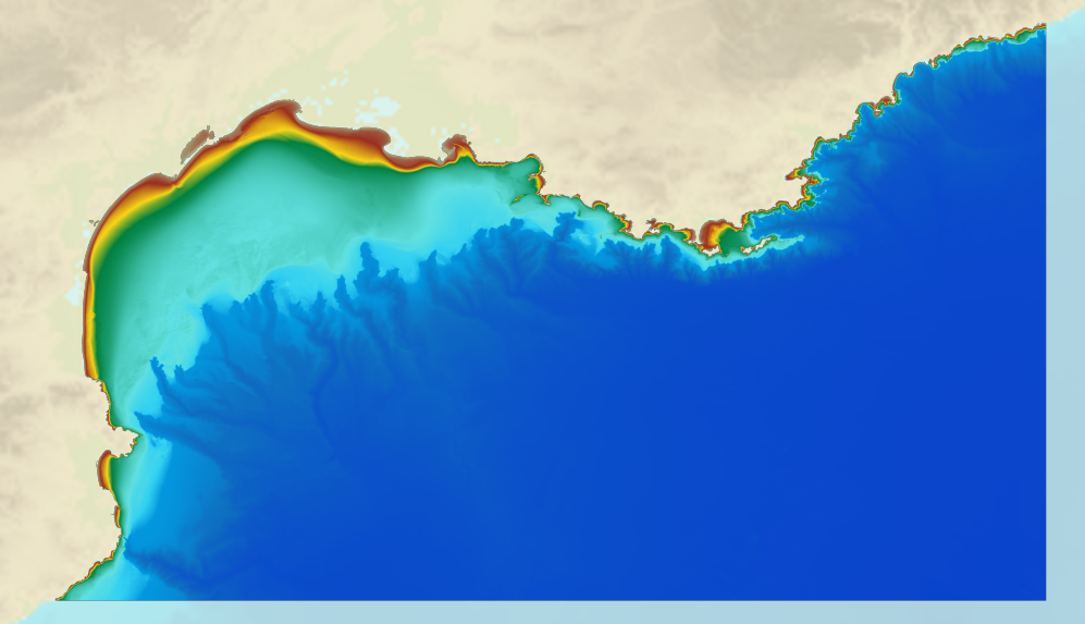
Bathymetric DEM for the coasts of Gulf of Lion and Côte d'Azur (Project Homonim)
A bathymetric DEM for the coasts of Gulf of Lion – Côte d’Azur with a resolution of 0.001° (~ 100 m) was prepared as part of the HOMONIM project.
It covers the entire Mediterranean metropolitan facade.
The model ranges off-shore to a depth of 2800 m.
The DEM is designed to be used in hydrodynamic models in order to produce high-precision forecasts for coastal water levels and sea conditions and therefore improve the pertinence of the Waves-Submersion monitoring programme.
This product is available with the Lowest Astronomic Tide (LAT) or the Mean Sea Level (MSL) as a vertical datum.
|
|
Citation proposal
. Bathymetric DEM for the coasts of Gulf of Lion and Côte d'Azur (Project Homonim). https://services.data.shom.fr:/geonetwork/srv/api/records/MNT_MED100m_GDL_CA_HOMONIM_WGS84.xml |
Simple
- Date ( Creation )
- 2015-09-11T00:00:00
- Presentation form
- Digital map
- Credit
-
©Shom
Owner
- Maintenance and update frequency
- Not planned
- GEMET - INSPIRE themes, version 1.0 ( Theme )
-
-
Elevation
-
- Keywords ( Theme )
-
-
bathymetry
-
digital elevation model
-
Product
-
open data
-
- Keywords ( Place )
-
-
Golfe du Lion
-
Côte d'Azur
-
Mer Méditerranée
-
- Keywords ( Discipline )
-
-
Geophysic
-
- INSPIRE Spatial scope
- High-value dataset categories
- Use limitation
-
Data may be freely used providing that the source is mentioned as follows "Shom,2015. MNT Bathymétrique de façade du Golfe du Lion - Côte d'Azur (Projet Homonim). http://dx.doi.org/10.17183/MNT_MED100m_GDL_CA_HOMONIM_WGS84".
- Use limitation
-
Data may not be modified or distributed without the agreement of the distributor.
- Use limitation
-
Do not use for navigation
- Use limitation
-
The product is distributed under an Opendata license (version 2.0, April 2017), defined by the Etalab mission.
- Use limitation
-
Data may not be modified or distributed without the agreement of the distributor.
- Access constraints
- License
- Use constraints
- Other restrictions
- Other constraints
-
Data may be freely used providing that the source is mentioned as follows "Shom,2015. MNT Bathymétrique de façade du Golfe du Lion - Côte d'Azur (Projet Homonim). http://dx.doi.org/10.17183/MNT_MED100m_GDL_CA_HOMONIM_WGS84".
- Access constraints
- Other restrictions
- Other constraints
- Pas de restriction d'accès public. No public access restrictions.
- Classification
- Unclassified
- Spatial representation type
- Grid
- Distance
- 0.001 dd
- Metadata language
- fre French
- Character set
- utf8 UTF8
- Topic category
-
- Elevation
))
Vertical extent
- Minimum value
- -2844
- Maximum value
- 10
Vertical CS
Vertical datum
Vertical extent
- Minimum value
- -2844
- Maximum value
- 10
Vertical CS
Vertical datum
- Reference system identifier
-
EPSG
/WGS 84 (EPSG:4326)
/7.9
- Number of dimensions
- 2
- Dimension name
- Row
- Dimension size
- 5001
- Resolution
- 0.001 dd
- Dimension name
- Column
- Dimension size
- 2701
- Resolution
- 0.001 dd
- Cell geometry
- Area
- Transformation parameter availability
- false
- Distribution format
-
-
ArcGis Grid
(-
) -
BAG
(-
) -
GLZ
(-
) -
GRD
(-
)
-
Distributor
- OnLine resource
- Shom geoportal
- OnLine resource
-
MNT_MED100m_GDL_CA_HOMONIM_PBMA_3857_WMSR
Bathymetric DEM Gulf of Lion - Côte d'Azur raster WMS
- OnLine resource
- Download service LAT
- OnLine resource
- Download service MSL
- OnLine resource
- Shom distribution space
- Hierarchy level
- Dataset
Conformance result
- Date ( Publication )
- 2010-11-23
- Explanation
-
Information sur la conformité au règlement d'interopérabilité des séries et des services de données géographiques.
- Pass
- true
Conformance result
- Date ( Publication )
- 2013-12-10
- Explanation
-
Information sur la conformité de la ressource à une spécification (INSPIRE).
- Pass
- true
- Statement
-
This DEM uses data from the EMODnet GLOBAL DEM: « This portal was initiated by the European Commission as part of developing the European Marine Observation and Data Network (EMODnet). The overall objective of EMODnet is to create pilots to migrate fragmented and inaccessible marine data into interoperable, continuous and publicly available data streams for complete maritime basins. The Hydrography portal development started in June 2009 and now provides a range of options for freely browsing and downloading new Digital Terrain Models (DTM) for a large part of the European seas. The downloadable tiles are freely available in a number of formats. The EMODnet digital bathymetry has been produced from bathymetric survey data and aggregated bathymetry data sets collated from public and private organizations. These are processed and quality controlled. A further refinement and expansion is underway, by gathering additional survey data sets, expanding geographical coverage to all European sea regions and upgrading the DTM grid resolution, and will result in new releases in time. The portal also includes a metadata discovery service that gives clear information about the background survey data used for the DTMs, their access restrictions, originators and distributors. »
GEBCO bathymetric grid may be used to prepare the DEM for any non-commercial purpose, without need for prior approval.
- Description
-
The main tasks involved in producing this range of solutions are based on 4 key aspects, each intended to reduce uncertainty for the DEM:
1) collecting, evaluating, pre-processing and selecting data from multiple sources after acquisition using survey systems from various eras;
2) homogenising the vertical and horizontal datums for data sets;
3) using interpolation algorithms suitable for a heterogeneous distribution and the variable density of data, and
4) evaluating and qualifying the final product and preparing documentation.
gmd:MD_Metadata
- File identifier
- MNT_MED100m_GDL_CA_HOMONIM_WGS84.xml XML
- Metadata language
- French
- Character set
- UTF8
- Hierarchy level
- Dataset
- Date stamp
- 2015-11-03T09:36:02
- Metadata standard name
-
ISO 19115:2003/19139
- Metadata standard version
-
1.0
Point of contact
Overviews
Provided by
