 Catalogue Shom
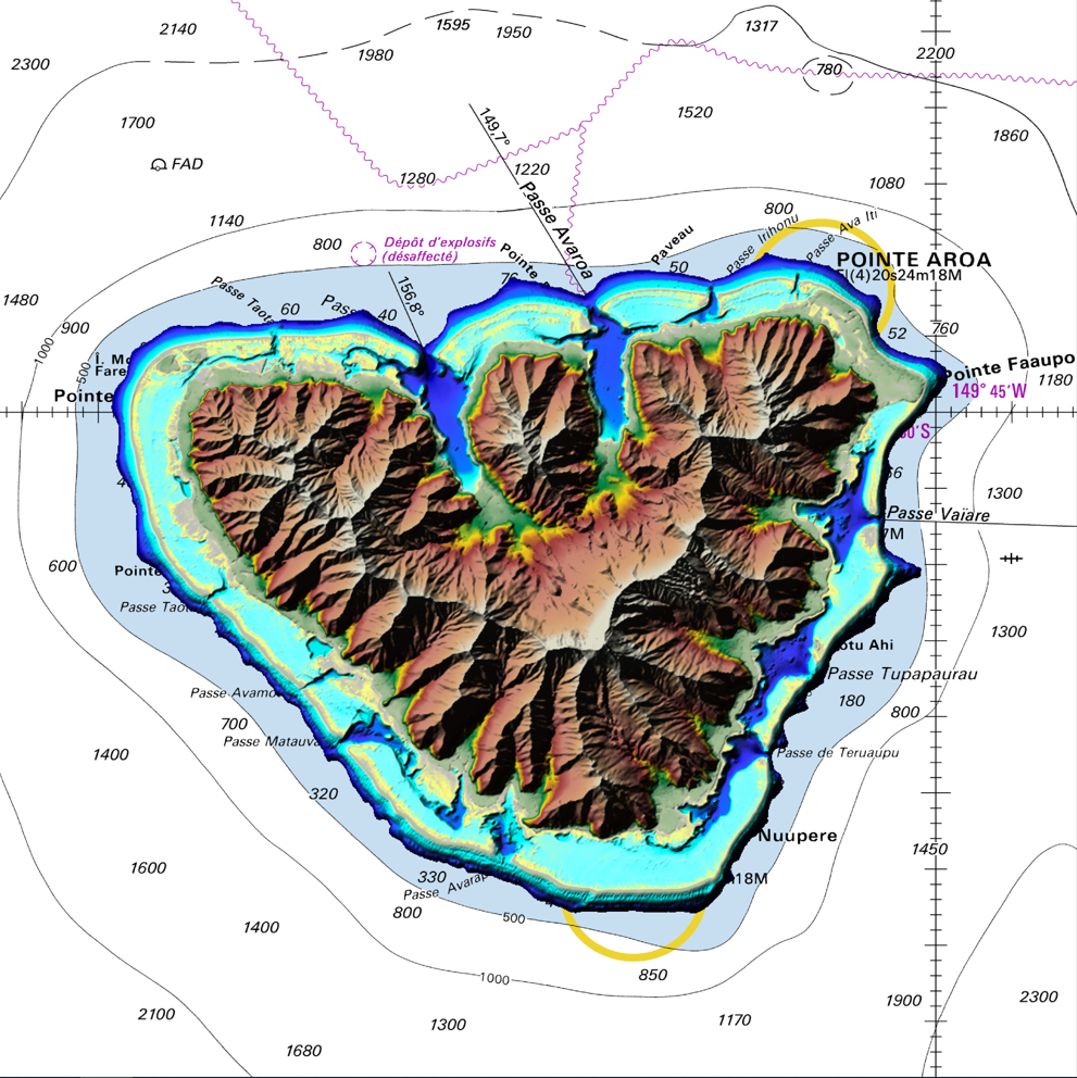
Coastal topo-bathymetric DEM of Moorea
The coastal topo-bathymetric DEM of Moorea with a resolution of 0.0002° (~ 20 m) was produced by the Shom for Météo-France (Inter-regional Direction in French Polynesia).
This DEM covers the Moorea lagoons down to the 100 m isobath, in order to meet the need for modeling marine submersions in French Polynesia. It complements the bathymetric DEM of Tahiti and Moorea, with a resolution of 0.001° (~ 100 m).
This product is available at different vertical references, either the lowest astronomical tide (LAT) or the mean sea level (MSL).
|
|
Citation proposal
Shom. Coastal topo-bathymetric DEM of Moorea. https://services.data.shom.fr:/geonetwork/srv/api/records/MNT_COTIER_MOOREA_20m_WGS84.xml |
Simple
- Date ( Revision )
- 2023-12-12
- Edition
-
Edition 2.0
- Presentation form
- Digital map
- Credit
-
©Shom
Author
- Maintenance and update frequency
- Not planned
- GEMET - INSPIRE themes, version 1.0 ( Theme )
- Keywords ( Theme )
-
-
Bathymetry
-
Digital Elevation Model
-
Open data
-
Product
-
- Keywords ( Place )
-
-
Polynésie Française
-
Pacifique
-
- Keywords ( Discipline )
-
-
Geophysic
-
- High-value dataset categories
- Use limitation
-
Data may be freely used providing that the source is mentioned as follows : "Shom, 2023. MNT topo-bathymétrique côtier de Moorea (Projet Météo-France). http://dx.doi.org/10.17183/MNT_COTIER_MOOREA_METEO-FRANCE_20m_WGS84"
- Use limitation
-
Do not use for navigation
- Use limitation
-
Data may be freely used providing that the source is mentioned as follows : "Shom, 2023. MNT topo-bathymétrique côtier de Moorea (Projet Météo-France). http://dx.doi.org/10.17183/MNT_COTIER_MOOREA_METEO-FRANCE_20m_WGS84"
- Use limitation
-
Do not use for navigation
- Access constraints
- License
- Use constraints
- Other restrictions
- Other constraints
-
The product is distributed under an Opendata license (version 2.0, April 2017), defined by the Etalab mission.
- Access constraints
- Other restrictions
- Other constraints
- Pas de restriction d'accès public. No public access restrictions.
- Classification
- Unclassified
- Spatial representation type
- Grid
- Distance
- 0.0002 dd
- Metadata language
- fre French
- Character set
- utf8 UTF8
- Topic category
-
- Elevation
))
Vertical extent
- Minimum value
- -121
- Maximum value
- 1201
Vertical CS
Vertical datum
Vertical extent
- Minimum value
- -121
- Maximum value
- 1201
Vertical CS
Vertical datum
- Number of dimensions
- 2
- Dimension name
- Row
- Dimension size
- 801
- Resolution
- 0.0002 dd
- Dimension name
- Column
- Dimension size
- 1001
- Resolution
- 0.0002 dd
- Cell geometry
- Area
- Transformation parameter availability
- false
- Distribution format
-
-
ArcGis Grid
(inapplicable
) -
BAG
(inapplicable
) -
GLZ
(inapplicable
) -
GRD
(inapplicable
)
-
Distributor
- OnLine resource
-
Shom geoportal
Shom geoportal
- OnLine resource
- MNT_COTIER_MOOREA_20m_PBMA_3857_WMSR
- OnLine resource
- Download service LAT
- OnLine resource
- Download service MSL
- OnLine resource
-
Shom distribution space
Shom distribution space to download DEMs
- Hierarchy level
- Dataset
Conformance result
- Date ( Publication )
- 2013-12-10
- Explanation
-
Information on compliance with INSPIRE specifications for the Altitude theme.
- Pass
- true
Conformance result
- Date ( Publication )
- 2010-11-23
- Explanation
-
Information on compliance with the Geographic Data Sets and Services Interoperability Regulation.
- Pass
- true
- Statement
-
In addition to the Shom data, the surveys of external organisms have been used, with the following contributors :
IRD
Geopolynesie
- Description
-
The main production tasks of this product line are based on 4 major axes each aiming at reducing the DTM uncertainties:
1) the collection, evaluation, pre-processing, and selection of data from multiple sources whose acquisition is from different sensors and time periods;
2) homogenization of the vertical and horizontal reference of the data sets;
3) the use of interpolation algorithms adapted to the heterogeneous distribution and variable density of the data, and
4) the evaluation and qualification of the final product and the elaboration of its documentation
gmd:MD_Metadata
- File identifier
- MNT_COTIER_MOOREA_20m_WGS84.xml XML
- Metadata language
- fre French
- Character set
- UTF8
- Hierarchy level
- Dataset
- Date stamp
- 2024-02-01T12:00:47
- Metadata standard name
-
ISO 19115:2003/19139
- Metadata standard version
-
1.0
Point of contact
Overviews
Provided by
