 Catalogue Shom
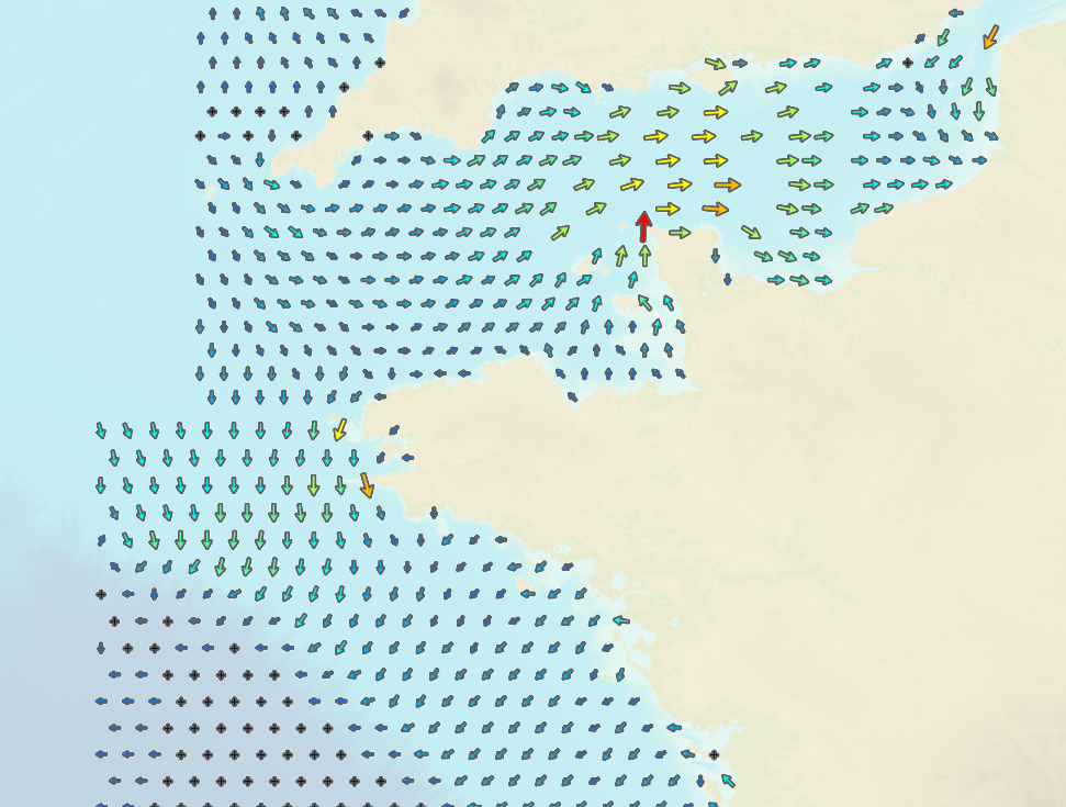
Tidal currents on French coasts (Channel/Atlantic)
This product includes all Shom digital files for tidal currents on mainland French coasts (Channel and Atlantic coasts) in mesh format. These digital files indicate surface tidal current components, hour by hour and for two typical tidal coefficients (45 and 95) and maximum current speeds for a mean spring tide. Brest is taken as the reference port for viewing purposes. The current points included in these files correspond to the arrows shown on current atlases.
|
|
Citation proposal
. Tidal currents on French coasts (Channel/Atlantic). https://services.data.shom.fr:/geonetwork/srv/api/records/MAREE_COURANTS_COURANTS2D.xml |
Simple
- Date ( Creation )
- 1988-01-01
- Date ( Revision )
- 2005-01-01
- Identifier
Point of contact
- Keywords ( Theme )
-
-
tide currents
-
Product
-
données ouvertes
-
- Use limitation
-
Data free of use by acknowledging its source. Open licence Etalab v. 2.0 avril 2017.
- Use limitation
-
Product not certified for navigation
- Use limitation
-
Data free of use by acknowledging its source. Open licence Etalab v. 2.0 avril 2017.
- Access constraints
- License
- Use constraints
- Other restrictions
- Other constraints
-
Open licence Etalab v. 2.0 avril 2017.
- Access constraints
- Other restrictions
- Other constraints
- Pas de restriction d'accès public. No public access restrictions.
- Classification
- Unclassified
- Spatial representation type
- Vector
- Metadata language
- fre French
- Character set
- utf8 UTF8
- Topic category
-
- Oceans
))
- Reference system identifier
-
EPSG
/WGS 84 (EPSG:4326)
/7.4
- Distribution format
-
-
TXT
(-
)
-
Point of contact
- OnLine resource
- Shom geoportal
- OnLine resource
- Download service
- OnLine resource
- Shom marketplace
- OnLine resource
-
COURANTS2D_WMSR_MEAP1_3857
WMS neap tide - high tide Brest +1h
- OnLine resource
-
COURANTS2D_WMSR_MEAP2_3857
WMS neap tide - high tide Brest +2h
- OnLine resource
-
COURANTS2D_WMSR_MEAP3_3857
WMS neap tide - high tide Brest +3h
- OnLine resource
-
COURANTS2D_WMSR_MEAP4_3857
WMS neap tide - high tide Brest +4h
- OnLine resource
-
COURANTS2D_WMSR_MEAP5_3857
WMS neap tide - high tide Brest +5h
- OnLine resource
-
COURANTS2D_WMSR_MEAP6_3857
WMS neap tide - high tide Brest +6h
- OnLine resource
-
COURANTS2D_WMSR_MEAV1_3857
WMS neap tide - high tide Brest -1h
- OnLine resource
-
COURANTS2D_WMSR_MEAV2_3857
WMS neap tide - high tide Brest -2h
- OnLine resource
-
COURANTS2D_WMSR_MEAV3_3857
WMS neap tide - high tide Brest -3h
- OnLine resource
-
COURANTS2D_WMSR_MEAV4_3857
WMS neap tide - high tide Brest -4h
- OnLine resource
-
COURANTS2D_WMSR_MEAV5_3857
WMS neap tide - high tide Brest -5h
- OnLine resource
-
COURANTS2D_WMSR_MEAV6_3857
WMS neap tide - high tide Brest -6h
- OnLine resource
-
COURANTS2D_WMSR_MEPM_3857
WMS neap tide - high tide Brest
- OnLine resource
-
COURANTS2D_WMSR_VEAP1_3857
WMS spring tide - high tide Brest +1h
- OnLine resource
-
COURANTS2D_WMSR_VEAP2_3857
WMS spring tide - high tide Brest +2h
- OnLine resource
-
COURANTS2D_WMSR_VEAP3_3857
WMS spring tide - high tide Brest +3h
- OnLine resource
-
COURANTS2D_WMSR_VEAP4_3857
WMS spring tide - high tide Brest +4h
- OnLine resource
-
COURANTS2D_WMSR_VEAP5_3857
WMS spring tide - high tide Brest +5h
- OnLine resource
-
COURANTS2D_WMSR_VEAP6_3857
WMS spring tide - high tide Brest +6h
- OnLine resource
-
COURANTS2D_WMSR_VEPM_3857
WMS spring tide - high tide Brest
- OnLine resource
-
COURANTS2D_WMSR_VEAV1_3857
WMS spring tide - high tide Brest -1h
- OnLine resource
-
COURANTS2D_WMSR_VEAV2_3857
WMS spring tide - high tide Brest -2h
- OnLine resource
-
COURANTS2D_WMSR_VEAV3_3857
WMS spring tide - high tide Brest -3h
- OnLine resource
-
COURANTS2D_WMSR_VEAV4_3857
WMS spring tide - high tide Brest -4h
- OnLine resource
-
COURANTS2D_WMSR_VEAV5_3857
WMS spring tide - high tide Brest -5h
- OnLine resource
-
COURANTS2D_WMSR_VEAV6_3857
WMS spring tide - high tide Brest -6h
- OnLine resource
-
COURANTS2D_WMSR_VMAX_3857
WMS max tide Brest
- Hierarchy level
- Dataset
Conformance result
- Date ( Publication )
- 2010-11-23
- Explanation
-
Information sur la conformité au règlement d'interopérabilité des séries et des services de données géographiques.
- Pass
- false
- Statement
-
Sources: The tidal currents included in the files are taken from tidal wave propagation digital simulation models focusing on a maritime environment. The models cover a larger geographic footprint than the data files, which match the cover of the corresponding atlases. The results for the boundary areas of models are less precise than results nearer the centre of the scope modelled, for this reason, the geographic scope of the files was reduced to exclude all lower quality data. Validation: Data are then subjected to several validation stages: adjusting physical and numerical parameters, adjusting the models to in-situ measurements, adjusting the models to each other to ensure that overlap areas coincide, interpolating using an looser even mesh and removing all overlap to obtain data from the digital solution; data with the highest level of spatial resolution is retained in overlap areas.
gmd:MD_Metadata
- File identifier
- MAREE_COURANTS_COURANTS2D.xml XML
- Metadata language
- fre French
- Character set
- UTF8
- Hierarchy level
- Dataset
- Hierarchy level name
-
Produit
- Date stamp
- 2013-01-29T14:09:07
- Metadata standard name
-
ISO 19115:2003/19139
- Metadata standard version
-
1.0
Point of contact
Overviews
Provided by
