 Catalogue Shom
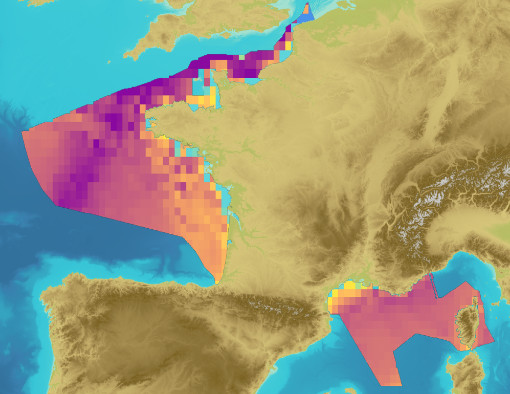
D11C2.1 - Spatial distribution of annual maximum levels per cell for the 1/3 octave band centered on 63Hz for 2012
Continuous sound is one of the criteria for defining good ecological status for descriptor 11 relating to the pressure of noise generated by human activities in the context of the MSFD (D11C2). Good ecological status for sound energy is achieved when the risks of acoustic disturbance, excess mortality from sound exposure and reduction in communication distances of mysticetes are cumulatively low or moderate. For this, the spatial distribution, the temporal extent and the acoustic levels of continuous anthropogenic sounds must not exceed levels harmful to populations of marine animals. These criteria are assessed at the scale of the marine sub-region for the "Channel and North Sea", "Celtic Seas" and "Western Mediterranean" regions; and at the scale of the "North" and "South" subdivisions in the "Bay of Biscay" sub-region. One of the indicators selected for the evaluation of criterion D11C2 is the spatial distribution of annual ambient noise for the one-third octave band centered on 63 Hz (D11C2.1). The pressure considered for the evaluation of the criterion is the noise generated by maritime traffic, mainly in its trade and transport component which is subject to regulatory oversight by automatic identification system (AIS). The data used for the calculation of this indicator are in situ noise data (MAMBO device) and maritime traffic data (Lloyd’s).
|
|
Citation proposal
Shom (2017) . D11C2.1 - Spatial distribution of annual maximum levels per cell for the 1/3 octave band centered on 63Hz for 2012. https://services.data.shom.fr:/geonetwork/srv/api/records/DCSMM_D11_C21_2012.xml |
Simple
- Date ( Publication )
- 2017-11-02
- Identifier
Author
- Keywords ( Theme )
-
-
Pollutions
-
MSFD
-
FMSP
-
Continouous sounds
-
63Hz
-
open data
-
- Use limitation
-
Data free of use by acknowledging its source: "Shom. http://dx.doi.org/10.17183/DCSMM_D11_C21_2012". Open licence Etalab v. 2.0 avril 2017.
- Use limitation
-
Product not certified for navigation
- Use limitation
-
Data free of use by acknowledging its source: : "Shom. http://dx.doi.org/10.17183/DCSMM_D11_C21_2012". Open licence Etalab v. 2.0 avril 2017.
- Access constraints
- License
- Use constraints
- Other restrictions
- Other constraints
-
Open licence Etalab v. 2.0 avril 2017.
- Access constraints
- Other restrictions
- Other constraints
- Pas de restriction d'accès public. No public access restrictions.
- Classification
- Unclassified
- Spatial representation type
- Vector
- Metadata language
- fre French
- Character set
- utf8 UTF8
- Topic category
-
- Oceans
))
- Distribution format
-
-
GeoTIFF
(1.1
) -
CSV
(inapplicable
) -
XML
(1.0
)
-
Point of contact
- OnLine resource
-
Shom geoportal
Shom geoportal
- OnLine resource
- DCSMM_D11_C21_2012_3857_WMSR
- OnLine resource
- Download service
- Hierarchy level
- Series
- Statement
-
The criteria D11C2 is evaluated by the mean quadratic pressure. The metric used is the value of the maximum sound level over a calendar year in the two third-octave bands centered on 63 Hz and 125 Hz respectively, expressed as sound levels expressed in dB re 1 µPa² with a spatial resolution of 1 minute of degree. These sound levels are inferred using a digital model, validated locally by in situ measurements. The data used are two types: - in situ noise data: the collection of this data come from of the MAMBO device (Acoustic Monitoring and Measurement by Noise of Opportunity). The system is based on a perennial network of measurement stations and the collection of opportunity data (incidence measurements, technological experiments, oceanographic monitoring, etc.) - maritime traffic data, mainly in its trade and transport component, collected by Lloyd’s for declarative port-to-port movements. The data subject to regulatory monitoring by Automatic Identification System (AIS) on land from the DAM (Direction des Affaires Maritimes) and provided by Cerema are supplemented by satellite and land data from Lloyd’s. The parameter evaluated in the indicator is the level of ambient traffic noise expressed in dB re 1 µPa². The calculation of the acoustic levels is carried out by integrating the levels on two frequency bands; the first centered on 63 Hz (from 56 Hz to 71 Hz, called the 1/3 octave band at 63 Hz) and the second on a frequency band centered on 125 Hz (from 112 Hz to 141 Hz, called the 1/3 octave at 125 Hz). The methodology for calculating this indicator is based on the joint use of in situ data (measurements on hydrophones) and digital models of noise generated by maritime traffic. For this assessment, the sound levels are calculated by modeling the monthly traffic noise, for the representative months of the four seasons (January, May, August and November) and for the depths of 5, 20, 30, 50, 80, 150 and 300 m (except for the English Channel - North Sea marine sub-region: 5, 20, 30, 50 and 80 m). The metric used is the annual maximum per cell for the months of calculation considered. To facilitate interpretation, we are interested in the distribution of maximum sound levels in the meshes of the MSR at percentiles 5, 25, 50, 75 and 95. The lack of in situ measurements does not allow the indicator to be evaluated. from real data. Otherwise, digital modeling is used and the results are validated locally by comparison with in-situ measurements. The model used is a statistical traffic noise model (CABAT, Calculation of Ambient Traffic Noise) used at Shom since 2006. The Good Ecological Status is qualitatively assessed taking into account the indicator, the level in the frequency band of 1/3 of an octave, specificities of the physics of acoustic propagation in each sub-region, and additional knowledge on maritime traffic monitoring. Three pressure levels are then defined: strong, moderate and low. These pressure levels are evaluated based on the magnitude of the trend relative to the uncertainty and its spatial distribution. The uncertainty in the model is at least 4 dB re 1 µPa², this is the basis for judging a significant increase or not. Moreover, one considers the spatial distribution of the interannual difference and one defines an acceptable threshold of 50% of the meshes for which there is a non-significant increase.
gmd:MD_Metadata
- File identifier
- DCSMM_D11_C21_2012.xml XML
- Metadata language
- French
- Character set
- UTF8
- Hierarchy level
- Series
- Hierarchy level name
-
Produit
- Date stamp
- 2021-10-07T11:24:22
- Metadata standard name
-
ISO 19115:2003/19139
- Metadata standard version
-
1.0
Point of contact
Overviews
Provided by
