 Catalogue Shom
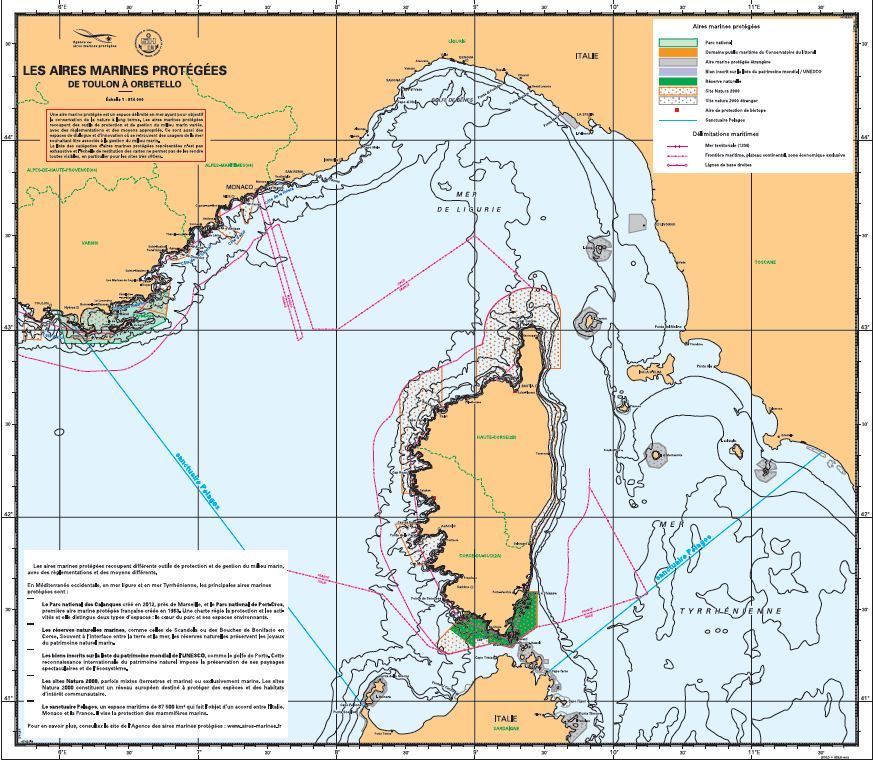
Maps of the network of protected marine areas in mainland France
The maps show the network of protected marine areas (AMP) in mainland France, used to inform users of sea conditions and to inform authorities via display boards in port offices or any other public location. A protected marine area is a defined area at sea intended to protect the natural environment on a long-term basis. The list of protected marine areas is not exhaustive and not all such areas are visible due to the chart scale.
|
|
Citation proposal
(2015) . Maps of the network of protected marine areas in mainland France. https://services.data.shom.fr:/geonetwork/srv/api/records/CARTES_SPECIALES_AMP.xml |
Simple
- Date ( Publication )
- 2015-03-23
- Identifier
- Presentation form
- Digital map
- Credit
-
Agence des aires marines protégées et Shom
Originator
- Maintenance and update frequency
- As needed
- Keywords ( Theme )
-
-
protected marine areas
-
marine nature park
-
Natura 2000
-
maritime public domain
-
biotope protection area
-
Pelagos santuary
-
national game and fishing reserve
-
biosphere reserve
-
nature reserve
-
national park
-
maritime boundaries
-
territorial sea
-
maritime borders
-
baseline
-
Product
-
Product
-
- Use limitation
-
Data may be freely used providing that the source is mentioned
- Use limitation
-
Do not use for navigation.
- Use limitation
-
Opendata license (version 2.0, April 2017), defined by the Etalab mission.
- Access constraints
- License
- Use constraints
- Other restrictions
- Other constraints
-
Data may be freely used providing that the source is mentioned.
- Classification
- Unclassified
- Metadata language
- fre French
- Character set
- utf8 UTF8
- Topic category
-
- Environment
))
- Distribution format
-
-
PDF
(1.5
)
-
Point of contact
- OnLine resource
- Download service map Britanny (from Barfleur to Noirmoutier)
- OnLine resource
- Download service map Bay of Biscay (from Noirmoutier to Hendaye)
- OnLine resource
-
Shom marketplace
Shom marketplace
- Hierarchy level
- Series
- Statement
-
Data used: Trait de côte Histolitt V2.0, Shom/IGN ;\\n- Aires marimes protégées (France et étrangères), Agence des Aires Marines Protégées ;\\n- Bathymétrie, Délimitations maritimes, Dispositif de séparation du trafic et Toponymes, Shom ;\\n - Limites de départements, GEOFLA (IGN).\\n
Softwares used : - Caris HPD-source éditor V3.0 \\n- ArcGIs 10.2.1\\n- Illustrator CS3
gmd:MD_Metadata
- File identifier
- CARTES_SPECIALES_AMP.xml XML
- Metadata language
- French
- Character set
- UTF8
- Hierarchy level
- Non geographic dataset
- Hierarchy level name
-
Produit
- Date stamp
- 2015-03-23T11:40:08
- Metadata standard name
-
ISO 19115:2003/19139
- Metadata standard version
-
1.0
Point of contact
Overviews
Provided by
