 Catalogue Shom
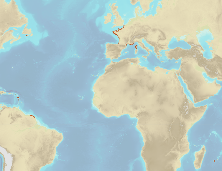
Limit of the preventive archeology licence fee
French Ministry of Culture / DRASSM – Shom
The product "Limit of preventive archeology licence fee" contains the limits for the preventive archeology licence fee (1 nautical mile) as defined in the French Heritage Code. This limit is managed by the Department of Underwater Archeological Research (DRASSM) of the Ministry of Culture.
This limit, defined by the Heritage Code at 1 nautical mile from the low-water line, permits to delineate the areas where the licence fee for preventive archeology at sea is applied.
In Mainland France in the Gironde estuary, the limit for the preventive archeology licence fee is stopped by the crosswise limit of the sea as defined by the decree of 26 August 1857.
In French Guiana, the limit for the preventive archeology licence fee is stopped in Maroni and Oyapock rivers by the crosswise limits of the sea respectively defined the order of 30 January 1991 and the order No 863 of 26 May 1986, until meeting the land boundary which delineates the rivers with the neighbouring States.
The product "Limit of preventive archeology licence fee" is to use in addition to the digital product “Maritime Limits and Boundaries” of Shom (French: “Délimitations maritimes”) which represents the limits of the French maritime spaces of sovereignty or jurisdiction through the World.
The product “Maritime Limits and Boundaries” (French: “Délimitations maritimes”) can be viewed on data.shom.fr (Maritime boundaries Category) and downloaded on the French national portal of maritime limits ( https://maritimelimits.gouv.fr).
|
|
Citation proposal
Shom - DRASSM. Limit of the preventive archeology licence fee. https://services.data.shom.fr:/geonetwork/srv/api/records/BDML_RAP.xml |
Simple
- Date ( Creation )
- 2020-02-15
- Identifier
Author
Author
- Keywords ( Theme )
-
-
maritime limits
-
regulation
-
preventive archelogy licence fee
-
preventive archelogy
-
DRASSM
-
Ministère de la Culture
-
open data
-
Product
-
- GEMET - INSPIRE themes, version 1.0 ( Theme )
- INSPIRE Spatial scope
- Use limitation
-
Data free of use by acknowledging its source. Open licence Etalab v. 2.0 avril 2017.
- Use limitation
-
Product not certified for navigation
- Use limitation
-
Data free of use by acknowledging its source. Open licence Etalab v. 2.0 avril 2017.
- Access constraints
- License
- Use constraints
- Other restrictions
- Other constraints
-
Open licence Etalab v. 2.0 avril 2017.
- Access constraints
- Other restrictions
- Other constraints
- Pas de restriction d'accès public. No public access restrictions.
- Classification
- Unclassified
- Spatial representation type
- Vector
- Metadata language
- fre French
- Character set
- utf8 UTF8
- Topic category
-
- Boundaries
))
- Distribution format
-
-
SHP
(inapplicable
) -
GML
(3.2
)
-
Point of contact
- OnLine resource
-
Shom geoportal
Shom geoportal
- OnLine resource
- Download link Limit of preventive archeology licence fee
- OnLine resource
-
French national portal of maritime limits
French national portal of maritime limits
- Hierarchy level
- Dataset
Conformance result
- Date ( Publication )
- 2010-11-23
- Explanation
-
Information sur la conformité au règlement d'interopérabilité des séries et des services de données géographiques.
- Pass
- true
Conformance result
- Date ( Publication )
- 2013-12-10
- Explanation
-
Information sur la conformité de la ressource à une spécification. NON EVALUE.
- Pass
- false
- Statement
-
Digital transcription of the limits defined in the official legal documents.
The maritime limits related to preventive archaeology licence fee (1 nautical mile) are computed by Shom on the basis of the elements of the low-water mark extracted from electronic navigational charts (ENC) published by Shom.
gmd:MD_Metadata
- File identifier
- BDML_RAP.xml XML
- Metadata language
- French
- Character set
- UTF8
- Hierarchy level
- Dataset
- Hierarchy level name
-
Produit
- Date stamp
- 2020-03-20T14:27:30
- Metadata standard name
-
ISO 19115:2003/19139
- Metadata standard version
-
1.0
Point of contact
Overviews
Provided by
