 Catalogue Shom
elevation
Type of resources
Available actions
Topics
Keywords
Provided by
Years
Formats
Representation types
Update frequencies
status
Scale
Resolution
-
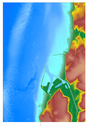
The coastal topo- bathymetric DEM for the coasts of Boulogne-Sur-Mer with a resolution of 0.0001° (~ 10 m) was prepared as part of the TANDEM project (Programme Investissements d'Avenir, ANR-11-RSNR-00023-01). The DEM covers the entire Boulogne-sur-Mer port, from north of Wimereux to south of the Boulogne-sur-Mer urban sprawl. The DEM is designed to be implemented in the hydrodynamic models of the TANDEM project in order to estimate the coastal effects of tsunamis for the Atlantic and English Channel, where French nuclear power plants have been installed for about 30 years. This product is available with the Lowest Astronomic Tide (LAT) or the Mean Sea Level (MSL) as a vertical datum.
-
The coastal topo-bathymetric DEM of Moorea with a resolution of 0.0002° (~ 20 m) was produced by the Shom for Météo-France (Inter-regional Direction in French Polynesia). This DEM covers the Moorea lagoons down to the 100 m isobath, in order to meet the need for modeling marine submersions in French Polynesia. It complements the bathymetric DEM of Tahiti and Moorea, with a resolution of 0.001° (~ 100 m). The vertical reference for this product is the Lowest Astronomical Tide (LAT).
-
The update of the coastal topo-bathymetric DEM of the Pertuis charentais at a resolution of 0.0002° (~ 20 m) was carried out in the third phase of the HOMONIM project. The DEM extends from the terrestrial domain to about 60 meters depth over all the pertuis (pertuis Breton, pertuis d’Antioche and pertuis of Maumusson). The DEM is intended to be implemented in hydrodynamic models in order to produce forecasts as accurate as possible of water heights and sea states at the coast to improve the relevance of the Wave-Submergence Vigilance. The vertical reference for this product is the Lowest Astronomical Tide (LAT).
-

This data layer contains the current status of hydrographic knowledge expressed in terms of CATZOC (category of zone of confidence, cf. https://iho.int/uploads/user/pubs/standards/S-67/S-67%20Ed%201.0.0%20Mariners%20Guide%20to%20Accuracy%20of%20Depth%20Information%20in%20an%20ENC_EN.pdf), as well as the target defined by the national hydrography program.
-

The coastal topo- bathymetric DEM of a part of the Norman-Breton gulf with a resolution of 0.0002° (~ 20 m) was prepared as part of the PAPI Saint-Malo. It covers the Minquiers plateau in the north-west to the bay of Mont-Saint-Michel in the south-east. The DEM is designed to be implemented in the hydrodynamic models of the TANDEM project in order to estimate the coastal effects of tsunamis for the Atlantic and English Channel, where French nuclear power plants have been installed for about 30 years. This product is available with the Lowest Astronomic Tide (LAT) or the Mean Sea Level (MSL) as a vertical datum.
-
The update of the coastal topo-bathymetric DEM of the Gironde estuary - downstream with a resolution of 0.0002° (~ 20 m) was carried out in the third phase of the HOMONIM project. This DEM covers the downstream part of the Gironde estuary, from Pauillac to its mouth. It is complementary to the DEM covering the upstream estuary. The DEM is intended to be implemented in hydrodynamic models in order to produce forecasts as accurate as possible of water heights and sea states at the coast to improve the relevance of the Wave-Submergence Vigilance. The vertical reference for this product is Mean Sea Level (MSL).
-
The update of the coastal topo-bathymetric DEM of the Pertuis charentais at a resolution of 0.0002° (~ 20 m) was carried out in the third phase of the HOMONIM project. The DEM extends from the terrestrial domain to about 60 meters depth over all the pertuis (pertuis Breton, pertuis d’Antioche and pertuis of Maumusson). The DEM is intended to be implemented in hydrodynamic models in order to produce forecasts as accurate as possible of water heights and sea states at the coast to improve the relevance of the Wave-Submergence Vigilance. The vertical reference for this product is Mean Sea Level (MSL).
-

The update of the coastal topo-bathymetric DEM of the Gironde estuary - downstream with a resolution of 0.0002° (~ 20 m) was carried out in the third phase of the HOMONIM project. This DEM covers the downstream part of the Gironde estuary, from Pauillac to its mouth. It is complementary to the DEM covering the upstream estuary. The DEM is intended to be implemented in hydrodynamic models in order to produce forecasts as accurate as possible of water heights and sea states at the coast to improve the relevance of the Wave-Submergence Vigilance. This product is available with either the Lowest Astronomic Tide (LAT) or the Mean Sea Level (MSL) as a vertical reference.
-
The coastal topobathymetric DEM of Ré Island's surroundings, with a resolution of 0.00005° (~5 meters), was created by Shom as part of the HOMONIM-3 project. It covers the coast of the municipalities of Ars-en-Ré and Saint-Clément-des-Baleines, extending offshore to a depth of about 20 meters, to the west of the Phare des Baleines lighthouse. This DEM is designed for use in hydrodynamic models to enhance the modeling of coastal processes, particularly forecasting submersion risk. The product complements the coastal topobathymetric DEM of the Pertuis-Charentais, with a resolution of 0.0002° (~20 meters), and the bathymetric DEM of the Atlantic coast, with a resolution of 0.001° (~100 meters). The vertical reference for this product is the Lowest Astronomical Tide (LAT).
-
The coastal topo-bathymetric DTM of the Arcachon basin and its surroundings at a resolution of 0.0002° (~ 20 m) was produced as part of the HOMONIM project. The DTM covers the coastline of a part of the Gironde department, from the Carcans and Hourtin ponds in the North, to the Cazaux and Sanguinet lakes in the South. It covers the entire Arcachon basin and extends offshore to about 40 m depth. The DTM is intended to be implemented in hydrodynamic models in order to produce accurate forecasts of water heights and sea states at the coast and to improve the French storm surge warning system.