Catalogue Shom
Tide gauge observations reference networks (REFMAR) - Partner tide gauges
Shom is the national referent for the level of the sea in situ on all areas under French jurisdiction. In this capacity, he assures under the acronym REFMAR different coordination functions in the collection and dissemination of public data related to water level observations, in order to promote their use in multiple applications within the framework of international recommendations.
|
|
Citation proposal
(2015) . Tide gauge observations reference networks (REFMAR) - Partner tide gauges. https://services.data.shom.fr:/geonetwork/WS/api/records/OBSERVATION_NIVEAU_MER_REFMAR_PARTENAIRES.xml |
Simple
- Date ( Publication )
- 2015-03-10
- Presentation form
- Digital map
- Credit
-
The SGMer has approved the instruction "on sea level observations and the dissemination of related data" (« relative à l'observation du niveau de la mer et à la gestion et à la diffusion des données en résultant ») (SGMer no. 863 of 20 April 2010, by way of delegation from the French Prime Minister, which formally appoints Shom as national coordinator and referral agent in the field. The acronym REFMAR, Réseaux de référence des observations marégraphiques (Reference network for tidge-gauge observations) is used for this purpose.
Originator
- Maintenance and update frequency
- Irregular
- Keywords ( Theme )
-
-
sea level observations
-
sea level
-
sea level
-
environment
-
product
-
open data
-
- GEMET - INSPIRE themes, version 1.0 ( Theme )
-
-
Environmental monitoring facilities
-
- Use limitation
-
Data may be freely used providing that the source is mentioned as follows "REFMAR. http://dx.doi.org/10.17183/REFMAR#PARTENAIRES"
- Use limitation
-
The product is distributed under an Opendata license (version 2.0, April 2017), defined by the Etalab mission.
- Use limitation
-
The product is distributed under an Opendata license (version 2.0, April 2017), defined by the Etalab mission.
- Access constraints
- License
- Use constraints
- Other restrictions
- Other constraints
-
Data may be freely used providing that the source is mentioned as follows "REFMAR. http://dx.doi.org/10.17183/REFMAR#PARTENAIRES"
- Access constraints
- Other restrictions
- Other constraints
- Pas de restriction d'accès public. No public access restrictions.
- Classification
- Unclassified
- Spatial representation type
- Text, table
- Metadata language
- fre French
- Character set
- utf8 UTF8
- Topic category
-
- Environment
))
- Supplemental Information
-
Les observations marégraphiques servent de nombreuses applications :
Étude des marées océaniques
Sécurité de la navigation (navigation côtière, réalisation des cartes marines, calcul des prédictions de marée, ...)
Détermination des références verticales (zéro hydrographique ou zéro des cartes marines, détermination des niveaux des plus basses / des plus hautes mers astronomiques, niveau moyen des mers, ...)
Études météo-océaniques (ENSO, El-Nino, La Nina, seiches, tempêtes, ...)
Niveaux extrêmes (statistiques sur les périodes de retour, ...)
Suivi à long terme des composantes du niveau de la mer comme l'évolution du niveau marin relatif et absolu (grâce à des antennes GNSS co-localisées aux observatoires marégraphiques. Cette activité est portée par SONEL, composant l'IR I-LICO
Intégration dans les modèles de prévisions océanographiques (mercator océan, ...)
Systèmes d'alerte au ondes de tempêtes (vigilance météorologique Vagues-Submersion) et aux tsunamis (CENALT, ...)
Validation des observations satellitaires (Jason 2, Jason 3, ...)
L'étude et la surveillance des variations climatiques récentes et actuelles du niveau de la mer s'organisent au niveau mondial autour du programme GLOSS (Global Sea Level Observing System) de la Commission Océanographique Intergouvernementale (COI) de l'UNESCO. Ce programme s'appuie notamment sur un réseau mondial de quelque 300 stations de marégraphie côtière autour duquel s'articulent des réseaux régionaux plus denses. Parmi elles, 16 stations françaises. Les stations GLOSS sont typiquement regroupées suivant cinq pôles d'intérêt scientifique :
- GLOSS-LTT, pour l'étude des tendances à long terme du niveau des mers ;
- GLOSS-ALT, pour la "calibration" des altimètres radar embarqués sur satellite ;
- GLOSS-OC, pour la surveillance de la circulation générale des océans ;
- GLOSS Sea-Level Station Monitoring Facility, pour l'amélioration des plates-formes d’acquisition et de transmission des données de niveau de la mer pour assurer la communication en temps quasi-réel ;
- GLOSS GNSS at Tide Gaude Data Centre (Tiga), pour la surveillance des déplacements verticaux du socle sur lequel reposent les marégraphes. Pour cette dernière mission, c'est SONEL qui joue le rôle de centre de données GNSS aux marégraphes. Les informations sont disponibles sur www.sonel.org
- Distribution format
-
-
TXT
(---
)- Specification
-
-
-
XML
(-
)- Specification
-
-
-
JSON
(-
)- Specification
-
-
-
Point of contact
- OnLine resource
-
Shom Geoportal
Shom Geoportal
- OnLine resource
-
Dowwload data
Dowwload data
- Hierarchy level
- Series
Conformance result
- Date ( Publication )
- 2010-11-23
- Explanation
-
Information sur la conformité au règlement d'interopérabilité des séries et des services de données géographiques.
- Pass
- true
- Statement
-
Several generations of devices have been used for sea level measurement in France:
- The tide scale with [the oldest systematic observations of sea level dates from 1679 and were made in Brest];
- The float tide gauge [first deployment in France at Toulon in 1842];
- Digital tide gauges with successively: pressure sensor, ultrasonic sensor and since the early 2000s the radar sensor.
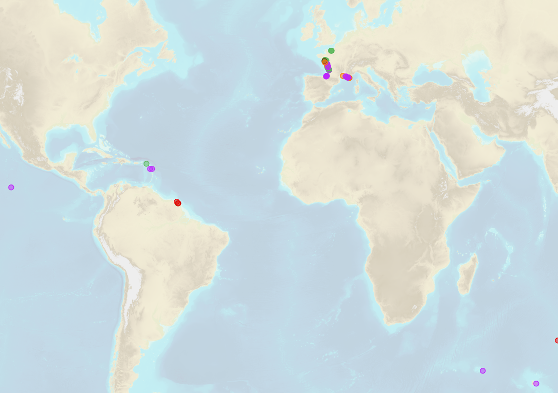
Data producers, REFMAR partners: thanks to the REFMAR activity, several organizations make available their sea level observations including:
- The Shom has in April 2017 a network of 46 tide gauges in mainland France and the Overseas: RONIM (Network of Observation of the Level of the Sea). Two other tide gauges complete the network: one in Monaco and the second in Madagascar;
- The ROSAME tide gauge network (Sub-Antarctic and Antarctic Observation Network at the level of MRE), which was created in the early 1990s is composed of four tide gauge observatories at Kergeluen, St Paul, Crozet Island and Dumont d'Urville;
- The DREAL-based flood forecasting services (SPC) deploy tide gauges in the estuaries as well as in the bays for their operational needs.
List of partners is available here: https://refmar.shom.fr
gmd:MD_Metadata
- File identifier
- OBSERVATION_NIVEAU_MER_REFMAR_PARTENAIRES.xml XML
- Metadata language
- French
- Character set
- UTF8
- Hierarchy level
- Series
- Hierarchy level name
- Date stamp
- 2018-03-02T14:41:17
- Metadata standard name
-
ISO 19115:2003/19139
- Metadata standard version
-
1.0
Point of contact
Overviews
Provided by