 Catalogue Shom
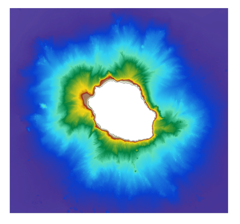
Bathymetric DEM for the coasts of la Réunion (Homonim project)
The bathymetric DEM for the coasts of La Réunion with a resolution of 0.001° (~ 100 m) was prepared as part of the HOMONIM project.
The DEM covers the entire Reunion island. The model ranges off-shore to a depth of 4000 m.
The DEM is designed to be used in hydrodynamic models in order to produce high-precision forecasts for coastal water levels and sea conditions and therefore improve the pertinence of the Waves-Submersion monitoring programme.
|
|
Citation proposal
. Bathymetric DEM for the coasts of la Réunion (Homonim project). https://services.data.shom.fr:/geonetwork/srv/api/records/MNT_REU100m_HOMONIM_WGS84.xml |
Simple
- Date ( Creation )
- 2015-09-09T00:00:00
- Presentation form
- Digital map
- Credit
-
©Shom
Owner
- Maintenance and update frequency
- Not planned
- GEMET - INSPIRE themes, version 1.0 ( Theme )
-
-
Elevation
-
- Keywords ( Theme )
-
-
bathymetry
-
digital elevation model
-
Product
-
open data
-
- Keywords ( Place )
-
-
La Réunion
-
Océan Indien
-
- Keywords ( Discipline )
-
-
Geophysic
-
- INSPIRE Spatial scope
- High-value dataset categories
- Use limitation
-
Data may be freely used providing that the source is mentioned as follows "Shom,2016. MNT bathymétrique de façade de La Réunion (Projet Homonim). http://dx.doi.org/10.17183/MNT_REU100m_HOMONIM_WGS84"
- Use limitation
-
Do not use for navigation
- Use limitation
-
The product is distributed under an Opendata license (version 2.0, April 2017), defined by the Etalab mission.
- Use limitation
-
Do not use for navigation
- Access constraints
- License
- Use constraints
- Other restrictions
- Other constraints
-
Data may be freely used providing that the source is mentioned as follows "Shom,2016. MNT bathymétrique de façade de La Réunion (Projet Homonim). http://dx.doi.org/10.17183/MNT_REU100m_HOMONIM_WGS84"
- Access constraints
- Other restrictions
- Other constraints
- Pas de restriction d'accès public. No public access restrictions.
- Classification
- Unclassified
- Spatial representation type
- Grid
- Distance
- 0.001 dd
- Metadata language
- fre French
- Character set
- utf8 UTF8
- Topic category
-
- Elevation
))
Vertical extent
- Minimum value
- -4480
- Maximum value
- 20
Vertical CS
Vertical datum
Vertical extent
- Minimum value
- -4480
- Maximum value
- 20
Vertical CS
Vertical datum
- Reference system identifier
-
EPSG
/WGS 84 (EPSG:4326)
/7.9
- Number of dimensions
- 2
- Dimension name
- Row
- Dimension size
- 2001
- Resolution
- 0.001 dd
- Dimension name
- Column
- Dimension size
- 1751
- Resolution
- 0.001 dd
- Cell geometry
- Area
- Transformation parameter availability
- false
- Distribution format
-
-
ArcGis Grid
(-
) -
BAG
(-
) -
GLZ
(-
) -
GRD
(-
)
-
Distributor
- OnLine resource
- Shom geoportal
- OnLine resource
-
MNT_REU100m_HOMONIM_PBMA_PYR_PNG_3857_WMSR
Bathymetric DEM Reunion island raster WMS
- OnLine resource
- Download service LAT
- OnLine resource
- Download service MSL
- OnLine resource
- Shom distribution space
- Hierarchy level
- Dataset
Conformance result
- Date ( Publication )
- 2010-11-23
- Explanation
-
Information sur la conformité au règlement d'interopérabilité des séries et des services de données géographiques.
- Pass
- true
Conformance result
- Date ( Publication )
- 2013-12-10
- Explanation
-
Information sur la conformité de la ressource à une spécification (INSPIRE).
- Pass
- true
- Statement
-
In addition to the Shom data, the surveys of external organisms have been exploited, the contributors of which are as follows: DDTM 974, DEAL de La Réunion, Grand Port Maritime de La Réunion, Ifremer (SAVOYE Bruno (2006) ERODER 1 cruise, RV Beautemps-Beaupré, http://dx.doi.org/10.17600/6090020), IPEV, IPGP (DEPLUS Christine (2006) FOREVER cruise, RV L'Atalante, http://dx.doi.org/10.17600/6010050), UBO-IUEM-LDO
- Description
-
The main tasks involved in producing this range of solutions are based on 4 key aspects, each intended to reduce uncertainty for the DEM:
1) collecting, evaluating, pre-processing and selecting data from multiple sources after acquisition using survey systems from various eras;
2) homogenising the vertical and horizontal datums for data sets;
3) using interpolation algorithms suitable for a heterogeneous distribution and the variable density of data, and
4) evaluating and qualifying the final product and preparing documentation.
gmd:MD_Metadata
- File identifier
- MNT_REU100m_HOMONIM_WGS84.xml XML
- Metadata language
- French
- Character set
- UTF8
- Hierarchy level
- Dataset
- Date stamp
- 2016-02-22T09:36:02
- Metadata standard name
-
ISO 19115:2003/19139
- Metadata standard version
-
1.0
Point of contact
Overviews
Provided by
