 Catalogue Shom
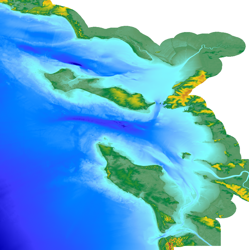
Coastal topo-bathymetric DEM for the Pertuis of Charente(HOMONIM project)
The update of the coastal topo-bathymetric DEM of the Pertuis charentais at a resolution of 0.0002° (~ 20 m) was carried out in the third phase of the HOMONIM project.
The DEM extends from the terrestrial domain to about 60 meters depth over all the pertuis (pertuis Breton, pertuis d’Antioche and pertuis of Maumusson).
The DEM is intended to be implemented in hydrodynamic models in order to produce forecasts as accurate as possible of water heights and sea states at the coast to improve the relevance of the Wave-Submergence Vigilance.
This product is available with either the Lowest Astronomic Tide (LAT) or the Mean Sea Level (MSL) as a vertical reference.
|
|
Citation proposal
Shom. Coastal topo-bathymetric DEM for the Pertuis of Charente(HOMONIM project). https://services.data.shom.fr:/geonetwork/srv/api/records/MNT_COTIER_PERTUIS_HOMONIM_20m_WGS84.xml |
Simple
- Date ( Revision )
- 2022-06-13
- Edition
-
Edition 2.0
- Presentation form
- Digital map
- Credit
-
©Shom
- Status
- On going
Author
- Maintenance and update frequency
- Not planned
- GEMET - INSPIRE themes, version 1.0 ( Theme )
- Keywords ( Theme )
-
-
Bathymetry
-
Digital Elevation Model
-
Open data
-
Product
-
- Keywords ( Place )
-
-
Pertuis Charentais
-
Golfe de Gascogne
-
- Keywords ( Discipline )
-
-
Geophysic
-
- High-value dataset categories
- Use limitation
-
Data may be freely used providing that the source is mentioned as follows : "Shom,2022. MNT topo-bathymétrique côtier des Pertuis Charentais (HOMONIM project). http://dx.doi.org/10.17183/MNT_COTIER_PERTUIS_HOMONIM_20m_WGS84."
- Use limitation
-
Do not use for navigation
- Use limitation
-
Data may be freely used providing that the source is mentioned as follows : "Shom,2022. MNT topo-bathymétrique côtier des Pertuis Charentais (HOMONIM project). http://dx.doi.org/10.17183/MNT_COTIER_PERTUIS_HOMONIM_20m_WGS84."
- Use limitation
-
Do not use for navigation
- Access constraints
- License
- Use constraints
- Other restrictions
- Other constraints
-
The product is distributed under an Opendata license (version 2.0, April 2017), defined by the Etalab mission.
- Access constraints
- Other restrictions
- Other constraints
- Pas de restriction d'accès public. No public access restrictions.
- Classification
- Unclassified
- Spatial representation type
- Grid
- Distance
- 0.0002 dd
- Metadata language
- fre French
- Character set
- utf8 UTF8
- Topic category
-
- Elevation
))
Vertical extent
- Minimum value
- -58
- Maximum value
- 62
Vertical CS
Vertical datum
Vertical extent
- Minimum value
- -61
- Maximum value
- 59
Vertical CS
Vertical datum
- Number of dimensions
- 2
- Dimension name
- Row
- Dimension size
- 3501
- Resolution
- 0.0002 dd
- Dimension name
- Column
- Dimension size
- 3751
- Resolution
- 0.0002 dd
- Cell geometry
- Area
- Transformation parameter availability
- false
- Distribution format
-
-
ArcGis Grid
(inapplicable
) -
BAG
(inapplicable
) -
GLZ
(inapplicable
) -
GRD
(inapplicable
)
-
Distributor
- OnLine resource
-
Shom geoportal
Shom geoportal
- OnLine resource
- Download service LAT
- OnLine resource
- Download service MSL
- OnLine resource
-
Shom distribution space
Shom distribution space to download DEMs
- Hierarchy level
- Dataset
Conformance result
- Date ( Publication )
- 2013-12-10
- Explanation
-
Information on compliance with INSPIRE specifications for the Altitude theme.
- Pass
- true
Conformance result
- Date ( Publication )
- 2010-11-23
- Explanation
-
Information on compliance with the Geographic Data Sets and Services Interoperability Regulation.
- Pass
- true
- Statement
-
In addition to the Shom data, the surveys of external organizations were exploited. Those contributors are the following :
Délégation à la Mer et au Littoral de la Vendée
DDTM de Charente-Maritime
Grand Port Maritime de Bordeaux
Grand Port Maritime de La Rochelle
IGN (RGEALTI® V2.0)
Laboratoire Central d'Hydraulique de France
- Description
-
The main production tasks of this product line are based on 4 major axes each aiming at reducing the DTM uncertainties:
1) the collection, evaluation, pre-processing, and selection of data from multiple sources whose acquisition is from different sensors and time periods;
2) homogenization of the vertical and horizontal reference of the data sets;
3) the use of interpolation algorithms adapted to the heterogeneous distribution and variable density of the data, and
4) the evaluation and qualification of the final product and the elaboration of its documentation
gmd:MD_Metadata
- File identifier
- MNT_COTIER_PERTUIS_HOMONIM_20m_WGS84.xml XML
- Metadata language
- fre French
- Character set
- UTF8
- Hierarchy level
- Dataset
- Date stamp
- 2023-06-29T14:06:07
- Metadata standard name
-
ISO 19115:2003/19139
- Metadata standard version
-
1.0
Point of contact
Overviews
Provided by
