Catalogue Shom
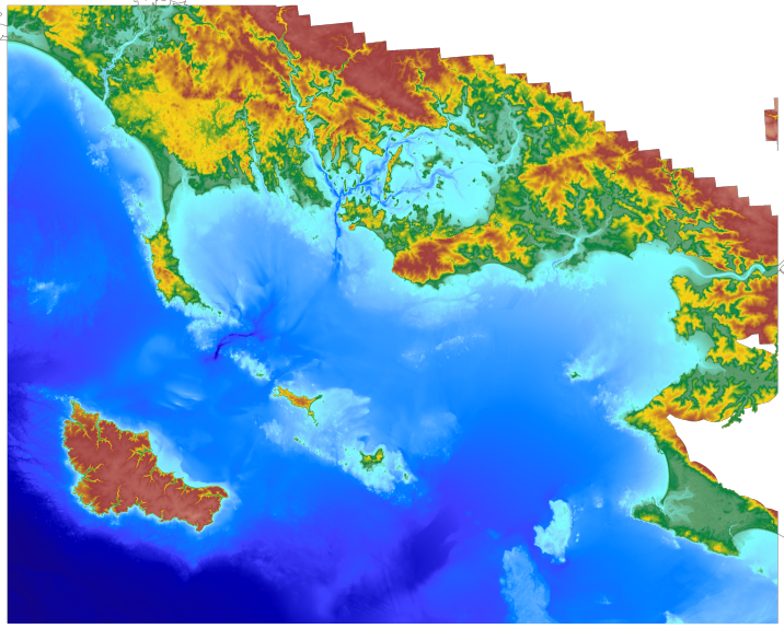
Coastal topo-bathymetric DEM for the Morbihan (TANDEM project)
The coastal topo- bathymetric DEM for the coasts of Morbihan with a resolution of 0.0002° (~ 20 m) was prepared as part of the TANDEM project (Programme Investissements d'Avenir, ANR-11-RSNR-00023-01).
It covers the French administrative department of Morbihan and part of Loire-Atlantique. This DEM runs from the Gâvres peninsula in the north west to La Baule in the south east and covers the Gulf of Morbihan, the Quiberon bay and peninsula, Houat, Hoëdic and Belle-Ile islands and the Vilaine estuary.
The DEM is designed to be implemented in the hydrodynamic models of the TANDEM project in order to estimate the coastal effects of tsunamis for the Atlantic and English Channel, where French nuclear power plants have been installed for about 30 years.
This product is available with the Lowest Astronomic Tide (LAT) or the Mean Sea Level (MSL) as a vertical datum.
|
|
Citation proposal
. Coastal topo-bathymetric DEM for the Morbihan (TANDEM project). https://services.data.shom.fr:/geonetwork/WS/api/records/MNT_COTIER_MORBIHAN_TANDEM_20m_WGS84.xml |
Simple
- Date ( Creation )
- 2015-10-19T00:00:00
- Presentation form
- Digital map
- Credit
-
©Shom
- Status
- On going
Owner
- Maintenance and update frequency
- Not planned
- GEMET - INSPIRE themes, version 1.0 ( Theme )
-
-
Elevation
-
- Keywords ( Theme )
-
-
topography
-
bathymetry
-
digital elevation model
-
Product
-
open data
-
- Keywords ( Place )
-
-
Golfe de Gascogne
-
Atlantique
-
- Keywords ( Discipline )
-
-
Geophysic
-
- High-value dataset categories
- Use limitation
-
Data may be freely used providing that the source is mentioned as follows "Shom,2015.MNT topo-bathymétrique côtier de la zone "Morbihan" à 20m (Projet TANDEM). http://dx.doi.org/10.17183/MNT_COTIER_MORBIHAN_TANDEM_20m_WGS84"
- Use limitation
-
Data may not be modified or distributed without the agreement of the distributor.
- Use limitation
-
Do not use for navigation
- Use limitation
-
The product is distributed under an Opendata license (version 2.0, April 2017), defined by the Etalab mission.
- Use limitation
-
Data may not be modified or distributed without the agreement of the distributor.
- Access constraints
- Other restrictions
- Use constraints
- License
- Other constraints
-
Data may be freely used providing that the source is mentioned as follows "Shom,2015.MNT topo-bathymétrique côtier de la zone "Morbihan" à 20m (Projet TANDEM). http://dx.doi.org/10.17183/MNT_COTIER_MORBIHAN_TANDEM_20m_WGS84"
- Access constraints
- Other restrictions
- Other constraints
- Pas de restriction d'accès public. No public access restrictions.
- Classification
- Unclassified
- Spatial representation type
- Grid
- Distance
- 0.0002 dd
- Metadata language
- fre French
- Character set
- utf8 UTF8
- Topic category
-
- Elevation
))
Vertical extent
- Minimum value
- -81.92
- Maximum value
- 90.16
Vertical CS
Vertical datum
Vertical extent
- Minimum value
- -79.09
- Maximum value
- 93.52
Vertical CS
Vertical datum
- Reference system identifier
-
EPSG
/WGS 84 (EPSG:4326)
/7.9
- Number of dimensions
- 2
- Dimension name
- Row
- Dimension size
- 2626
- Resolution
- 0.0002 dd
- Dimension name
- Column
- Dimension size
- 4834
- Resolution
- 0.0002 dd
- Cell geometry
- Area
- Transformation parameter availability
- false
- Distribution format
-
-
ArcGis Grid
(-
) -
BAG
(-
) -
GLZ
(-
) -
GRD
(-
)
-
Distributor
- OnLine resource
- Shom geoportal
- OnLine resource
-
MNT_COTIER_MORBIHAN_TANDEM_20m_PBMA_3857_WMSR
Bathymetric DEM Morbihan raster WMS
- OnLine resource
- Download service LAT
- OnLine resource
- Download service MSL
- OnLine resource
- Shom distribution space
- Hierarchy level
- Dataset
Conformance result
- Date ( Publication )
- 2010-11-23
- Explanation
-
Information sur la conformité au règlement d'interopérabilité des séries et des services de données géographiques.
- Pass
- true
Conformance result
- Date ( Publication )
- 2013-12-10
- Explanation
-
Information sur la conformité de la ressource à une spécification (INSPIRE).
- Pass
- true
- Statement
-
In addition to the Shom data, the surveys of external organisms have been exploited, the contributors of which are as follows: IGN, DDE Morbihan, Institution d'Aménagement de la Vilaine, Port Atlantique-Nantes-Saint-Nazaire, Syndicat Mixte de la Ria d'Etel.
- Description
-
The main tasks involved in producing this range of solutions are based on 4 key aspects, each intended to reduce uncertainty for the DEM:
1) collecting, evaluating, pre-processing and selecting data from multiple sources after acquisition using survey systems from various eras;
2) homogenising the vertical and horizontal datums for data sets;
3) using interpolation algorithms suitable for a heterogeneous distribution and the variable density of data, and
4) evaluating and qualifying the final product and preparing documentation.
gmd:MD_Metadata
- File identifier
- MNT_COTIER_MORBIHAN_TANDEM_20m_WGS84.xml XML
- Metadata language
- French
- Character set
- UTF8
- Hierarchy level
- Dataset
- Date stamp
- 2015-11-03T09:36:02
- Metadata standard name
-
ISO 19115:2003/19139
- Metadata standard version
-
1.0
Point of contact
Overviews
Provided by