 Catalogue Shom
Estimated Extreme Water Levels - Metropolitan Coastline, Edition 2022
This study provides an initial global estimate of the extreme water level values along the French metropolitan coastline. These results are to be refined locally with all available data and knowledge.
The method used is based on a statistical analysis of the tide gauge observations available in the ports. It does not take into account wave observations. The results between ports are obtained by an interpolation method.
The study produces at the reference ports the statistical estimates:
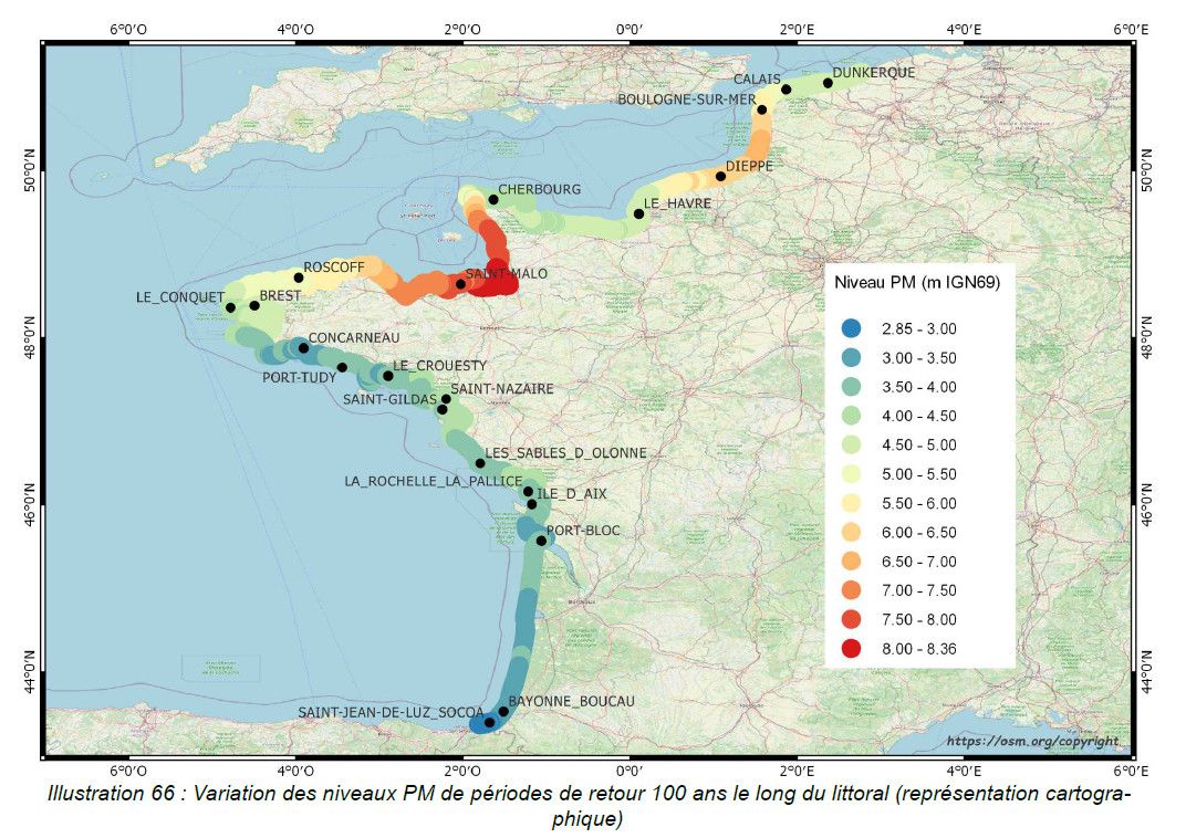
- extreme values of high water surge in the Channel and Atlantic;
- extreme values of water level for the whole of Metropolitan France.
And a set of statistical estimation maps of extreme water level values along the coastline.
The estimates provided go up to the 1,000-year return period. In view of the duration of observations used at the ports, the user must check whether estimates with a return period of more than 50 or 100 years are still valid 50 or 100 years still make sense.
|
|
Citation proposal
Shom - Cerema - DTecREM / DREL. Estimated Extreme Water Levels - Metropolitan Coastline, Edition 2022. https://services.data.shom.fr:/geonetwork/srv/api/records/MAREE_COURANTS_NIV_EXTR.xml |
Simple
- Date ( Revision )
- 2022-12-17
- Edition
-
Edition 2022
- Identifier
- Credit
-
©Cerema-Shom
Author
Author
- Keywords ( Theme )
-
-
extreme sea levels
-
product
-
open data
-
- Use limitation
-
Data may be freely used providing that the source is mentioned as follows : "Cerema-Shom: Estimation des valeurs extrêmes de niveau d'eau – Littoral métropolitain, Édition 2022."
- Use limitation
-
Do not use for navigation
- Use limitation
-
Data may be freely used providing that the source is mentioned as follows : "Cerema-Shom: Estimation des valeurs extrêmes de niveau d'eau – Littoral métropolitain, Édition 2022."
- Use limitation
-
Do not use for navigation
- Access constraints
- License
- Use constraints
- Other restrictions
- Other constraints
-
Open license (version 2.0, April 2017), defined by the Etalab mission.
- Access constraints
- Other restrictions
- Other constraints
- Pas de restriction d'accès public. No public access restrictions.
- Classification
- Unclassified
- Spatial representation type
- Vector
- Metadata language
- fre French
- Character set
- utf8 UTF8
- Topic category
-
- Oceans
))
- Distribution format
-
-
SHAPEFILE
(inapplicable
) -
PDF
(inapplicable
) -
TXT
(inapplicable
)
-
Distributor
- OnLine resource
-
Shom geoportal
Shom geoportal
- OnLine resource
-
NIVEAUX_EXTREMES_PYR_PNG_3857_WMSR
Access point / WMS Estimated extreme water levels
- OnLine resource
- Download service
- OnLine resource
-
Shom distribution space
Shom distribution space to download DEMs
- Hierarchy level
- Dataset
Conformance result
- Date ( Publication )
- 2010-11-23
- Explanation
-
Information on compliance with the Geographic Data Sets and Services Interoperability Regulation.
- Pass
- true
- Statement
-
Sources : Estimation des valeurs extrêmes de niveau d'eau – Littoral métropolitain, Édition 2022, Cerema-Shom 2022
gmd:MD_Metadata
- File identifier
- MAREE_COURANTS_NIV_EXTR.xml XML
- Metadata language
- fre French
- Character set
- UTF8
- Hierarchy level
- Dataset
- Hierarchy level name
-
Produit
- Date stamp
- 2023-10-23T14:09:07
- Metadata standard name
-
ISO 19115:2003/19139
- Metadata standard version
-
1.0
Point of contact
Overviews
Provided by
