Catalogue Shom
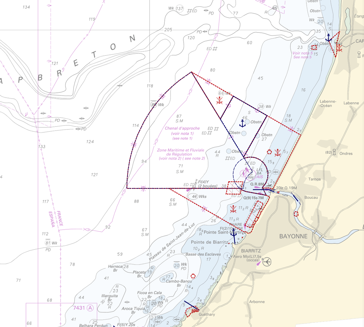
Regulation - Navigation
"Regulation - Navigation" product contains 18 object classes, the acronyms used are those of IHO standard S-57 - International Hydrographic Organization – ( https://iho.int/):
- Anchorage area (ACHARE): an area in which vessels anchor or may anchor.
- Anchor berth (ACHBRT): a designated area of water where a single vessel, sea plane, etc. may anchor.
- Administration Area (Named) (ADMARE)
- Cable area (CBLARE)
- Coastguard station (CGUSTA)
- Cargo transhipment area (CTSARE)
- Distance mark (DISMAR): mark indicating the distance on canals or rivers.
- Dumping ground (DMPGRD): sea area where dredged material or other potentially more harmful material e.g. explosives, chemical waste, is deliberately deposited.
- Fairway (FAIRWY): part of a river, harbour etc. where the main navigable channel for vessels of larger size lies. It is also the usual course followed by vessels entering or leaving harbours and sometimes called "ship channel".
- Ice area (over land or water) (ICEARE)
- Local magnetic anomaly (LOCMAG): anomaly of the magnetic field of the earth, extending over a relatively small area, due to local magnetic influences.
- Marine farm/culture (MARCUL)
- Navigation line (NAVLNE): a line generally passing through two clearly defined charted landmarks, and along part of which a vessel can approach safely.
- Pipeline area (PIPARE)
- Recommended track (RECTRC): track of undefined width, recommended to all or only certain vessels.
- Restricted area (RESARE): specified area designated by an appropriate authority within which navigation is restricted in accordance with certain specified conditions.
- Sea-plane landing area (SPLARE)
Detailed definitions of each of these object classes can be found in the S-57 standard ( https://iho.int/en/standards-and-specifications).
An online catalog is available at http://www.s-57.com/.
Some of the symbols used for display on data.shom.fr portal have been adapted from icons from the OpenSeaMap open library ( https://github.com/OpenNauticalChart/).
For reasons of readability, not all the characteristics of the objects are systematically displayed. All available information can be consulted by querying this layer.
|
|
Citation proposal
. Regulation - Navigation. https://services.data.shom.fr:/geonetwork/WS/api/records/BDML_REGLEMENTATION_NAVIGATION.xml |
Simple
- Date ( Creation )
- 2021-06-16
- Credit
-
©Shom
Point of contact
- Keywords ( Theme )
-
-
ACHARE
-
ACHBRT
-
ADMARE
-
CBLARE
-
CGUSTA
-
CTSARE
-
DISMAR
-
DMPGRD
-
FAIRWY
-
ICEARE
-
LOCMAG
-
MARCUL
-
NAVLNE
-
PIPARE
-
RECTRC
-
RESARE
-
SPLARE
-
Open data
-
Product
-
- GEMET - INSPIRE themes, version 1.0 ( Theme )
- INSPIRE Spatial scope
- High-value dataset categories
- High-value dataset categories
- Use limitation
-
Data may be freely used providing that the source is mentioned as follows "Shom, 2021. Regulation - Navigation"
- Use limitation
-
Do not use for navigation
- Use limitation
-
Data may be freely used providing that the source is mentioned as follows "Shom, 2021. Regulation - Navigation"
- Access constraints
- License
- Use constraints
- Other restrictions
- Other constraints
-
Open licence Etalab v. 2.0 avril 2017.
- Access constraints
- Other restrictions
- Other constraints
- Pas de restriction d'accès public. No public access restrictions.
- Classification
- Unclassified
- Spatial representation type
- Vector
- Metadata language
- fre French
- Character set
- utf8 UTF8
- Topic category
-
- Transportation
))
- Distribution format
-
-
SHP
(inapplicable
)
-
Point of contact
- OnLine resource
-
Shom Geoportal
Shom Geoportal
- OnLine resource
-
REGLEMENTATION_NAVIGATION_BDD_WMSV
WMS Regulation - Navigation
- OnLine resource
- Download link TO DO
- OnLine resource
-
Shom marketplace
Shom marketplace
- Hierarchy level
- Dataset
Conformance result
- Date ( Publication )
- 2010-11-23
- Explanation
-
Information sur la conformité au règlement d'interopérabilité des séries et des services de données géographiques.
- Pass
- true
Conformance result
- Date ( Publication )
- 2014-04-17
- Explanation
-
Information sur la conformité de la ressource à une spécification (INSPIRE).
- Pass
- false
Conformance result
- Date ( Publication )
- 2013-12-10
- Explanation
-
Information sur la conformité de la ressource à une spécification (INSPIRE).
- Pass
- false
Conformance result
- Date ( Publication )
- 2013-12-10
- Explanation
-
Information sur la conformité de la ressource à une spécification (INSPIRE).
- Pass
- false
Conformance result
- Date ( Publication )
- 2013-12-10
- Explanation
-
Information sur la conformité de la ressource à une spécification.
- Pass
- false
- Statement
-
The information used in the elaboration of this product has been collected by Shom from various sources. It is based on Shom's knowledge of the marine environment and is used in the preparation of its products, including nautical charts.
gmd:MD_Metadata
- File identifier
- BDML_REGLEMENTATION_NAVIGATION.xml XML
- Metadata language
- fre French
- Character set
- UTF8
- Hierarchy level
- Dataset
- Hierarchy level name
-
Produit
- Date stamp
- 2021-06-30T10:42:11
- Metadata standard name
-
ISO 19115:2003/19139
- Metadata standard version
-
1.0
Point of contact
Overviews
Provided by