 Catalogue Shom
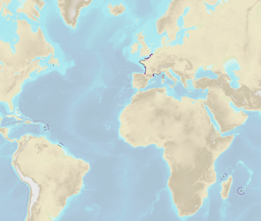
Limits related to fishery uses
French Ministry of Agriculture and Food / DRASSM - Shom<br />
The product "Limits related to fishery uses" contains the limits related to fishery uses as defined in the French or European legislations. Those limits are managed by the Directorate for Sea Fisheries and Aquaculture (DPMA) of the Ministry of Agriculture and Food. <br />
Those limits are divided into three categories : <br />
- the inner limit of the coastal waters (6 nautical miles) ; <br />
- the 3-nautical-mile limit ; <br />
- the limit of fisheries for overseas territories (100 nautical miles).<br /><br />
The product "Limits related to fishery uses" is to use in addition to the digital product “Maritime Limits and Boundaries” of Shom (French: “Délimitations maritimes”) which represents the limits of the French maritime spaces of sovereignty or jurisdiction through the World.<br />
The product “Maritime Limits and Boundaries” (French: “Délimitations maritimes”) can be viewed on data.shom.fr (Maritime boundaries Category) and downloaded on the French national portal of maritime limits ( https://maritimelimits.gouv.fr).
|
|
Citation proposal
Shom - DPMA. Limits related to fishery uses. https://services.data.shom.fr:/geonetwork/srv/api/records/BDML_LIMITES_PECHE.xml |
Simple
- Date ( Creation )
- 2020-02-15
- Identifier
Author
Author
- Keywords ( Theme )
-
-
maritime limits
-
regulation
-
fisheries
-
3 nautical miles
-
6 nautical miles
-
100 nautical miles
-
coastal waters
-
Overseas territories
-
DPMA
-
Ministry of Agriculture and Food
-
open data
-
Product
-
- GEMET - INSPIRE themes, version 1.0 ( Theme )
- INSPIRE Spatial scope
- High-value dataset categories
- Use limitation
-
Data free of use by acknowledging its source. Open licence Etalab v. 2.0 avril 2017.
- Use limitation
-
Product not certified for navigation
- Use limitation
-
Data free of use by acknowledging its source. Open licence Etalab v. 2.0 avril 2017.
- Access constraints
- License
- Use constraints
- Other restrictions
- Other constraints
-
Open licence Etalab v. 2.0 avril 2017.
- Access constraints
- Other restrictions
- Other constraints
- Pas de restriction d'accès public. No public access restrictions.
- Classification
- Unclassified
- Spatial representation type
- Vector
- Metadata language
- fre French
- Character set
- utf8 UTF8
- Topic category
-
- Boundaries
))
- Distribution format
-
-
SHP
(inapplicable
) -
GML
(3.2
)
-
Point of contact
- OnLine resource
-
Shom geoportal
Shom geoportal
- OnLine resource
- LIMITES_PECHE_BDD_WMSV
- OnLine resource
- LIMITES_PECHE_BDD_WFS:limite_3milles_peche_wgs84_epsg4326
- OnLine resource
-
LIMITES_PECHE_BDD_WFS:limite_6milles_bande_cotiere_peche_wgs84_epsg4326
Access point Inner limit of the coastal waters (6 nautical miles)
- OnLine resource
-
LIMITES_PECHE_BDD_WFS:limite_100milles_peche_outre_mer_wgs84_epsg4326
Limit of fisheries for overseas territories (100 nautical miles)
- OnLine resource
- Download link Limits related to fishery uses
- OnLine resource
-
French national portal of maritime limits
French national portal of maritime limits
- Hierarchy level
- Dataset
Conformance result
- Date ( Publication )
- 2010-11-23
- Explanation
-
Information sur la conformité au règlement d'interopérabilité des séries et des services de données géographiques.
- Pass
- true
Conformance result
- Date ( Publication )
- 2013-12-10
- Explanation
-
Information sur la conformité de la ressource à une spécification.
- Pass
- true
- Statement
-
Digital transcription of the limits defined in the official legal documents.
The maritime limits related to fishery uses (3, 6 and 100 nautical miles) are computed by Shom on the basis of the elements of the low-water mark extracted from electronic navigational charts (ENC) published by Shom and from in force baselines.
gmd:MD_Metadata
- File identifier
- BDML_LIMITES_PECHE.xml XML
- Metadata language
- French
- Character set
- UTF8
- Hierarchy level
- Dataset
- Hierarchy level name
-
Produit
- Date stamp
- 2020-04-20T14:27:30
- Metadata standard name
-
ISO 19115:2003/19139
- Metadata standard version
-
1.0
Point of contact
Overviews
Provided by
