 Catalogue Shom
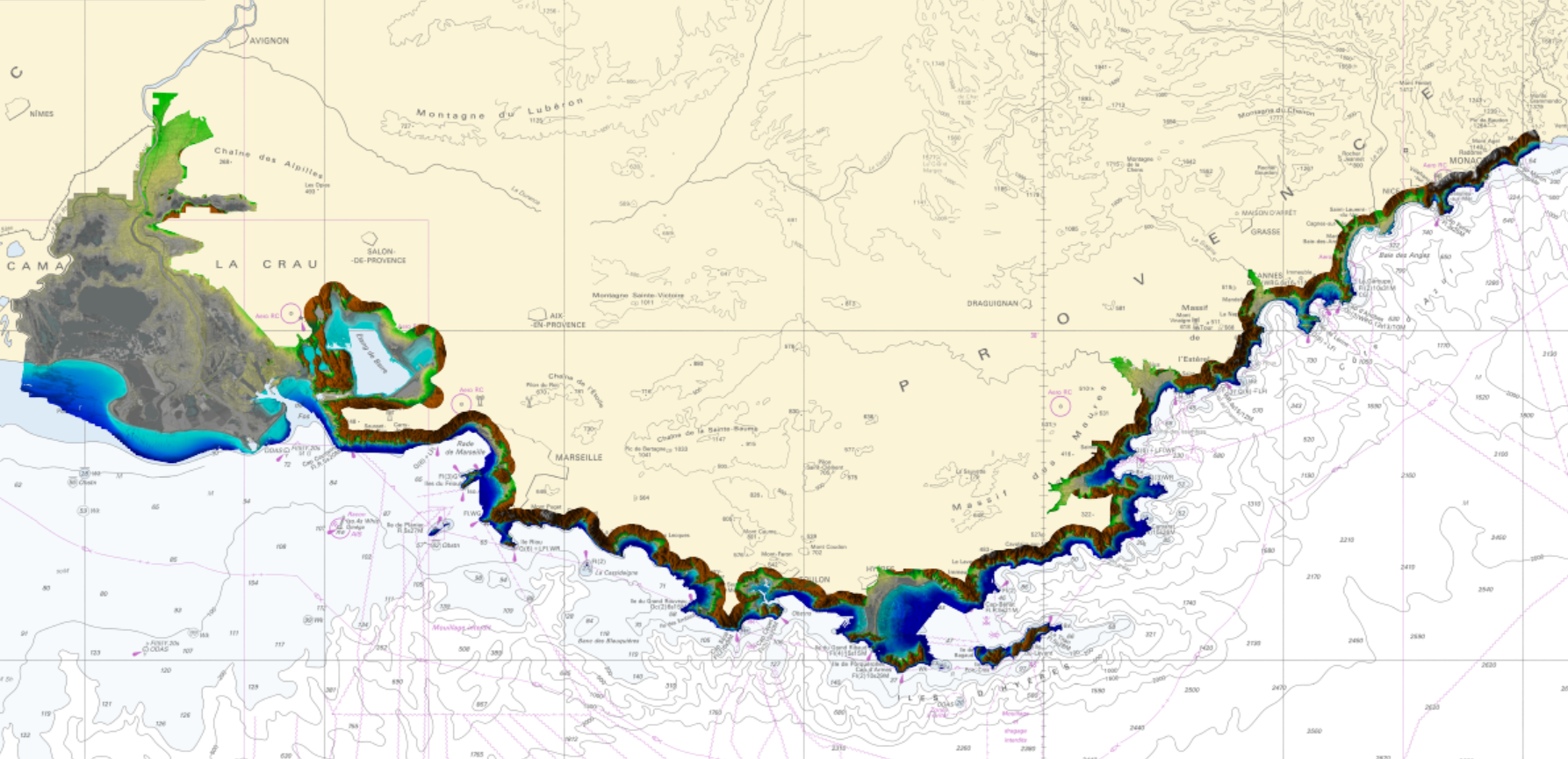
LITTO3D® PACA 2015
Litto3D is a unique and continuous land-sea database which can provide 3D models of the shape and location of French coastal terrain. A line separates sea and land data acquisition zones, and the associated survey readings obtained using bathymetric lidar technologies or multibeam echosounders for sea readings and airborne lidar topographical surveys for land readings, with 300 m overlap. Litto3D digital models are available in two formats: a set of 3D points and a qualified terrain mesh.
|
|
Citation proposal
(2015) . LITTO3D® PACA 2015. https://services.data.shom.fr:/geonetwork/srv/api/records/BATHYMETRIE_LITTO3D_PACA_2015.xml |
Simple
- Alternate title
-
Land-sea altimetric database
- Date ( Publication )
- 2015-01-28
- Edition
-
Edition 1.0
- Presentation form
- Digital map
- Purpose
-
The main aim is to produce precise digital data with unrivalled resolution (decimetric precision, metric resolution) for French coastal terrain. This solution provides the basic data required to implement many applications and public policies, such as:
• Risk prevention (tsunamis, cyclone swell, rising sea level due to global warming, coastal flooding, flooding, erosion, etc.),
• Coastal planning studies (roads, ports, etc.),
• improved knowledge of the public maritime territory, tracking coastal withdrawal,
• mapping terrestrial and marine habitats,
• creating current models and related applications (tidal and swell current energy, waste dispersal at sea, sedimentary movements, etc.)
• Integrated Coastal Zone Management (ICZM).
- Credit
-
This approach is led by Shom (Service Hydrographique et Océanographique de la Marine - Oceanography and Hydrography Service of the French Navy) and IGN (French institute for geographical and forestry information), in partnership with the Provence-Alpes-Côte d'Azur Region, the Prefecture of the PACA region, the Toulon Provence Méditerranée Agglomeration Community, and the Defense Infrastructure Service (SID).
Litto3D® in the Provence-Alpes-Côte d'Azur (PACA) region is co-funded by the European Union . Europe contributes to projects in the Provence-Alpes-Côte d'Azur region via the European Regional Development Fund (ERDF).
Originator
- Maintenance and update frequency
- Irregular
- Keywords ( Theme )
-
-
Product
-
open data
-
- Use limitation
-
The product is distributed under an Opendata license (version 2.0, April 2017), defined by the Etalab mission.
- Use limitation
-
Data may be freely used providing that the source is mentioned.
- Use limitation
-
Do not use for navigation
- Use limitation
-
The product is distributed under an Opendata license (version 2.0, April 2017), defined by the Etalab mission.
- Access constraints
- License
- Use constraints
- Other restrictions
- Other constraints
-
No public restriction.
- Classification
- Unclassified
- Spatial representation type
- grid Grid
- Distance
- 1 m
- Metadata language
- fre French
- Character set
- utf8 UTF8
- Topic category
-
- Elevation
- Description
-
PACA
))
- Reference system identifier
-
EPSG
/RGF93 / Lambert-93 (EPSG:2154)
/7.4
- Distribution format
-
-
ASC
(-
) -
XYZ
(-
)
-
Point of contact
- OnLine resource
- Shom geoportal
- OnLine resource
-
LITTO3D_PACA_2015_PYR_3857_WMSR
LITTO3D® PACA 2015 raster WMS
- OnLine resource
- Download service
- OnLine resource
- Shom distribution space
- Hierarchy level
- Series
Conformance result
- Date ( Publication )
- 2010-11-23
- Explanation
-
Information sur la conformité au règlement d'interopérabilité des séries et des services de données géographiques. Conformité non évaluée.
- Statement
-
The DEM (Digital Elevation Model) is accompanied by layers, which add local metadata. Each layer is supported by the same even mesh as the DEM. One layer provides information on the source of most data used to calculate the node, for each node, and the second layer provides information on the evaluation of the distance between the node in question and the different known points used to calculate altitude.
The bathymetric and topographic data come from various survey systems: Shoals 3000, HawkEye IIb and LADS MkIII. Topographic and bathymetric data (mixed survey system) for very shallow water (generally down to a depth of 2-3 m, with deeper local areas) were obtained from a RIEGL VQ-820-G survey system.
Topographical data are acquired using a ALTM31000AE-IGN survey system.
These bathymetric and topographic data were acquired between 30 September and 2 October 2007, between 5 and 7 October 2010 and between 30 April 2012 and 12 July 2013.
gmd:MD_Metadata
- File identifier
- BATHYMETRIE_LITTO3D_PACA_2015.xml XML
- Metadata language
- fre French
- Character set
- UTF8
- Hierarchy level
- Series
- Hierarchy level name
-
Collection de données
- Date stamp
- 2019-05-21T17:20:26
- Metadata standard name
-
ISO 19115:2003/19139
- Metadata standard version
-
1.0
Point of contact
Overviews
Provided by
