Catalogue Shom
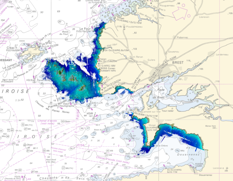
LITTO3D® marine part Iroise Marine Natural Park 2012
Litto3D Marine Part is an intermediate product of the Litto3D product containing only marine data.Litto3D is a unique and continuous land-sea database which can provide 3D models of the shape and location of French coastal terrain. A line separates sea and land data acquisition zones, and the associated survey readings obtained using bathymetric lidar technologies or multibeam echosounders for sea readings and airborne lidar topographical surveys for land readings, with 300 m overlap. Litto3D digital models are available in two formats: a set of 3D points and a qualified terrain mesh.
|
|
Citation proposal
(2012) . LITTO3D® marine part Iroise Marine Natural Park 2012. https://services.data.shom.fr:/geonetwork/WS/api/records/BATHYMETRIE_L3D_MAR_PNMI_2012.xml |
Simple
- Alternate title
-
Land-sea altimetric database
- Date ( Publication )
- 2012-07-26
- Presentation form
- Digital map
- Purpose
-
The main aim is to produce precise digital data with unrivalled resolution (decimetric precision, metric resolution) for French coastal terrain. This solution provides the basic data required to implement many applications and public policies, such as:
• Risk prevention (tsunamis, cyclone swell, rising sea level due to global warming, coastal flooding, flooding, erosion, etc.),
• Coastal planning studies (roads, ports, etc.),
• improved knowledge of the public maritime territory, tracking coastal withdrawal,
• mapping terrestrial and marine habitats,
• creating current models and related applications (tidal and swell current energy, waste dispersal at sea, sedimentary movements, etc.)
• Integrated Coastal Zone Management (ICZM).
- Credit
-
This operation, led by the Marine Protected Areas Agency (AAMP) and the Marine Natural Park of Iroise (PNMI), was carried out in partnership with the Shom (Hydrographic and Oceanographic Service of the Navy), acting as assistant to the client, particularly in charge of the control and validation of bathymetric data.
Originator
- Maintenance and update frequency
- Irregular
- Keywords ( Theme )
-
-
Product
-
open data
-
- Use limitation
-
The product is distributed under an Opendata license (version 2.0, April 2017), defined by the Etalab mission.
- Use limitation
-
Data may be freely used providing that the source is mentioned.
- Use limitation
-
Do not use for navigation
- Use limitation
-
The product is distributed under an Opendata license (version 2.0, April 2017), defined by the Etalab mission.
- Access constraints
- License
- Use constraints
- Other restrictions
- Other constraints
-
No public restriction.
- Classification
- Unclassified
- Spatial representation type
- grid Grid
- Distance
- 5 m
- Metadata language
- fre French
- Character set
- utf8 UTF8
- Topic category
-
- Elevation
- Description
-
Iroise
))
- Reference system identifier
-
EPSG
/RGF93 / Lambert-93 (EPSG:2154)
/7.9
- Distribution format
-
-
ASC
(-
) -
XYZ
(-
)
-
Point of contact
- OnLine resource
- Shom geoportal
- OnLine resource
-
L3D_MAR_PNMI_2012_PYR_3857_WMSR
LITTO3D® marine part Parc Naturel Marin d'Iroise 2012 raster WMS
- OnLine resource
- Download service
- OnLine resource
- Shom distribution space
- Hierarchy level
- Series
Conformance result
- Date ( Publication )
- 2010-11-23
- Explanation
-
Information sur la conformité au règlement d'interopérabilité des séries et des services de données géographiques.
Conformité non évaluée.
- Pass
- false
- Statement
-
Bathymetric data come from a Hawk Eye Mk II sensor.
Points describe the sea floor and terrain (see note below on topographical data). Long-term anthropic structures (hard constructions such as dikes, wrecks, turrets, lighthouses or piles) will be maintained.
Note on topographical data: A topographical mode is also available for this survey system and can be used to measure abovewater terrain with a higher density (~ 1 point / m²). Only topographical points used to define the land-sea interface were subjected to an exhaustive checking and validation process. In particular, topsoil is not processed (removal of plants and anthropic structures, etc.) on land. On a long-term basis, these topographical data will be replaced with IGN topographical data within the Litto3D® product.
gmd:MD_Metadata
- File identifier
- BATHYMETRIE_L3D_MAR_PNMI_2012.xml XML
- Metadata language
- fre French
- Character set
- UTF8
- Hierarchy level
- Series
- Hierarchy level name
-
Collection de données
- Date stamp
- 2022-03-05T13:51:21
- Metadata standard name
-
ISO 19115:2003/19139
- Metadata standard version
-
1.0
Point of contact
Overviews
Provided by