Catalogue Shom
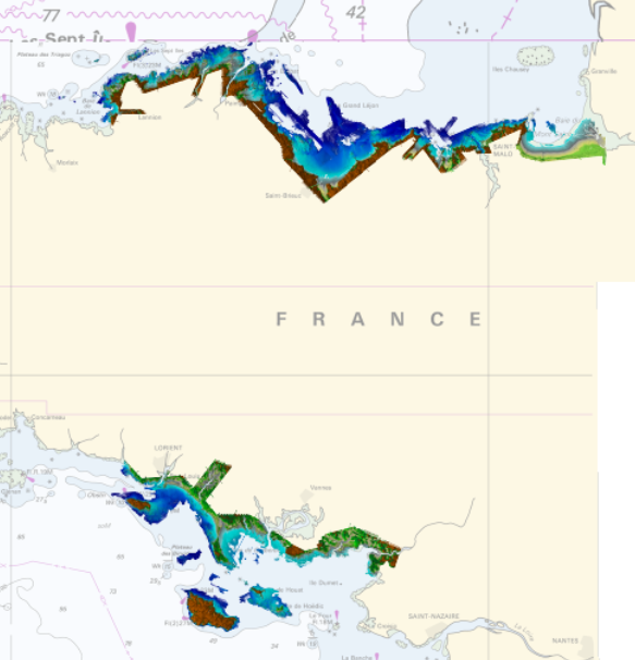
Litto3D® marine part - Brittany 2018-2021
Product replaced by Litto3D® - Brittany 2018-2021. https://services.data.shom.fr/geonetwork/srv/fre/catalog.search#/metadata/BATHYMETRIE_LITTO3D_BZH_2018_2021.xml
|
|
Citation proposal
Shom. Litto3D® marine part - Brittany 2018-2021. https://services.data.shom.fr:/geonetwork/WS/api/records/BATHYMETRIE_L3D_MAR_BZH_2018_2021.xml |
Simple
- Alternate title
-
Land-sea altimetric database
- Date ( Creation )
- 2021-07-02
- Presentation form
- Digital map
Author
- Maintenance and update frequency
- Irregular
- Keywords ( Theme )
-
- Use limitation
-
Product replaced by Litto3D® - Brittany 2018-2021. https://services.data.shom.fr/geonetwork/srv/fre/catalog.search#/metadata/BATHYMETRIE_LITTO3D_BZH_2018_2021.xml
- Spatial representation type
- Grid
- Spatial representation type
- Vector
- Distance
- 1 m
- Distance
- 5 m
- Metadata language
- fre French
- Character set
- utf8 UTF8
- Topic category
-
- Elevation
- Description
-
France, Bretagne
))
- Distribution format
-
-
ASC
(inapplicable
) -
XYZ
(inapplicable
)
-
Distributor
- OnLine resource
-
Shom geoportal
Shom geoportal
- OnLine resource
-
Shom distribution space to download data
Shom distribution space to download tiles
- OnLine resource
-
Metadata of the new product.
Metadata of the new product.
- Hierarchy level
- Series
- Statement
-
Product replaced by Litto3D® - Brittany 2018-2021
gmd:MD_Metadata
- File identifier
- BATHYMETRIE_L3D_MAR_BZH_2018_2021.xml XML
- Metadata language
- fre French
- Character set
- utf8 UTF8
- Hierarchy level
- Series
- Hierarchy level name
-
Collection de données
- Date stamp
- 2023-02-24T12:37:58
- Metadata standard name
-
ISO 19115:2003/19139
- Metadata standard version
-
1.0
Point of contact
Overviews
Provided by