 Catalogue Shom
Lidar French Polynesia 2015 - Bora Bora SAU V.20160630
Lidar marine part is a unique and continuous land-sea database which can provide 3D models of the shape and location of French coastal terrain. A line separates sea and land data acquisition zones, and the associated survey readings obtained using bathymetric lidar technologies or multibeam echosounders for sea readings and airborne lidar topographical surveys for land readings, with 300 m overlap. Litto3D digital models are available in two formats: a set of 3D points and a qualified terrain mesh.
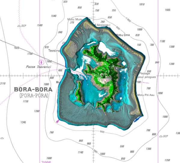
The product Bora Bora SAU 2015 v.20160630 covers a geographical area corresponding to the whole island, the lagoon and the reef of Bora Bora.
|
|
Citation proposal
(2016) . Lidar French Polynesia 2015 - Bora Bora SAU V.20160630. https://services.data.shom.fr:/geonetwork/srv/api/records/BATHYMETRIE_L3D_LIDAR_POLYNESIE_BOR_2015.xml |
Simple
- Alternate title
-
Land-sea altimetric database
- Date ( Publication )
- 2016-06-30
- Presentation form
- Digital map
- Purpose
-
The main aim is to produce precise digital data with unrivalled resolution (decimetric precision, metric resolution) for French coastal terrain. This solution provides the basic data required to implement many applications and public policies, such as:
• Risk prevention (tsunamis, cyclone swell, rising sea level due to global warming, coastal flooding, flooding, erosion, etc.),
• Coastal planning studies (roads, ports, etc.),
• improved knowledge of the public maritime territory, tracking coastal withdrawal,
• mapping terrestrial and marine habitats,
• creating current models and related applications (tidal and swell current energy, waste dispersal at sea, sedimentary movements, etc.)
• Integrated Coastal Zone Management (ICZM).
- Credit
-
The "French Polynesia Lidar 2015 - Bora Bora" operation was commissioned by the French Polynesia Urban Planning Department (SAU), with Shom providing project management assistance.
Originator
- Maintenance and update frequency
- Irregular
- Keywords ( Theme )
-
-
Product
-
open data
-
- GEMET - INSPIRE themes, version 1.0 ( Theme )
-
-
Elevation
-
- Use limitation
-
The product is distributed under an Opendata license (version 2.0, April 2017), defined by the Etalab mission.
- Use limitation
-
Data may be freely used providing that the source is mentioned as follows "Shom-SAU, 2015. http://dx.doi.org/10.17183/LIDAR_POLYNESIE_BOR_V20160630".
- Use limitation
-
Do not use for navigation
- Use limitation
-
The product is distributed under an Opendata license (version 2.0, April 2017), defined by the Etalab mission.
- Access constraints
- License
- Use constraints
- Other restrictions
- Other constraints
-
No public restriction.
- Classification
- Unclassified
- Spatial representation type
- Grid
- Distance
- 1 m
- Metadata language
- fre French
- Character set
- utf8 UTF8
- Topic category
-
- Elevation
- Description
-
Bora Bora
))
- Reference system identifier
-
EPSG
/RGPF / UTM zone 5S (EPSG:3296)
/7.9
- Distribution format
-
-
ASC
(-
) -
XYZ
(-
)
-
Point of contact
- OnLine resource
- Shom geoportal
- OnLine resource
-
L3D_LIDAR_POLYNESIE_BOR_2015_WMSR_3857
Lidar French Polynesia Bora Bora 2015 raster WMS
- OnLine resource
- Download service
- OnLine resource
- Shom distribution space
- Hierarchy level
- Series
Conformance result
- Date ( Publication )
- 2010-11-23
- Explanation
-
Information sur la conformité au règlement d'interopérabilité des séries et des services de données géographiques. Conformité non évaluée.
- Pass
- undefined
- Statement
-
These data were acquired by airborne bathymetric and topo-bathymetric lidars during a cruise conducted between June 10, 2015 and June 26, 2015.
The bathymetric data come from two sensors and the topographic data come from a single sensor:
- Deep LADS mk3 bathymetric laser for deep depths,
- Topo-bathymetric laser RIEGL VQ-820-G for shallow depths.
gmd:MD_Metadata
- File identifier
- BATHYMETRIE_L3D_LIDAR_POLYNESIE_BOR_2015.xml XML
- Metadata language
- fre French
- Character set
- UTF8
- Hierarchy level
- Series
- Hierarchy level name
-
Collection de données
- Date stamp
- 2018-04-16T12:03:27
- Metadata standard name
-
ISO 19115:2003/19139
- Metadata standard version
-
1.0
Point of contact
Overviews
Provided by
