 Catalogue Shom
GLZ
Type of resources
Available actions
Topics
Provided by
Years
Formats
Representation types
Update frequencies
status
Scale
Resolution
-
Modèle bathymétrique (MNT) à 100m de résolution de la façade maritime française de la Méditerranée de 0 à 50m de profondeur (ou 40km des côtes). La modélisation a été effectuée en 2010.
-
Modèle bathymétrique (MNT) à 100m de résolution de la ZPE de Méditerranée.
-
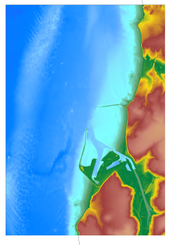
The coastal topo- bathymetric DEM for the coasts of Boulogne-Sur-Mer with a resolution of 0.0001° (~ 10 m) was prepared as part of the TANDEM project (Programme Investissements d'Avenir, ANR-11-RSNR-00023-01). The DEM covers the entire Boulogne-sur-Mer port, from north of Wimereux to south of the Boulogne-sur-Mer urban sprawl. The DEM is designed to be implemented in the hydrodynamic models of the TANDEM project in order to estimate the coastal effects of tsunamis for the Atlantic and English Channel, where French nuclear power plants have been installed for about 30 years. This product is available with the Lowest Astronomic Tide (LAT) or the Mean Sea Level (MSL) as a vertical datum.
-
Le produit topo-bathymétrique côtier de la zone "Morbihan" à une résolution de 0.0002° (~20 m) a été réalisé dans le cadre du projet TANDEM (Programme Investissements d'Avenir, ANR-11-RSNR-00023-01). Il couvre un secteur en-globant majoritairement le département du Morbihan et une partie de celui de la Loire-Atlantique. Ce MNT s’étend de la presqu'île de Gâvres au nord-ouest jusqu'à La Baule au sud-est, il englobe le golfe du Morbihan, la baie et la presqu'île de Quiberon, les îles d'Houat, Hoëdic et Belle-Ile, l'estuaire de la Vilaine… Ce MNT est destiné à être implémenté dans les modèles hydrodynamiques du projet TANDEM afin d'estimer les effets côtiers des tsunamis pour l’Atlantique et la Manche, où sont installées les centrales nucléaires françaises depuis environ 30 ans. La référence verticale de ce produit est le niveau des plus basses mers astronomiques.
-
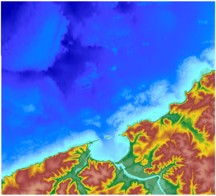
Le MNT topo-bathymétrique côtier d'une partie du golfe normand-breton à une résolution de 0.0002° (~ 20 m) a été réalisé dans le cadre du PAPI Saint-Malo. Le MNT englobe le plateau des Minquiers au Nord-Ouest jusqu'à la baie du Mont-Saint-Michel au Sud-Est. Le MNT est destiné à être implémenté dans les modèles hydrodynamiques afin de produire des prévisions aussi précises que possible des hauteurs d’eau et d’états de mer à la côte et donc d’améliorer la gestion du risque de submersion marine.
-
The coastal topo- bathymetric DEM for the coasts of the Saint-Jean-de-Luz bay with a resolution of 0.0002° (~ 20 m) was prepared as part of the TANDEM project. It covers Saint-Jean-de-Luz bay and the surrounding area. The DEM is designed to be implemented in the hydrodynamic models of the TANDEM project in order to estimate the coastal effects of tsunamis for the Atlantic and English Channel, where French nuclear power plants have been installed for about 30 years. This product is available with the Lowest Astronomic Tide (LAT) or the Mean Sea Level (MSL) as a vertical datum.
-
Le produit topo-bathymétrique côtier de la baie de Saint-Jean-de-Luz et ses abords, à une resolution de 0.0002° (~20 m), a été réalisé dans le cadre du projet TANDEM. Il couvre un territoire comprenant la baie de Saint-Jean-de-Luz et ses abords immediats. Ce MNT est destiné à être implémenté dans les modèles hydrodynamiques du projet TANDEM afin d'estimer les effets côtiers des tsunamis pour l’Atlantique et la Manche, où sont installées les centrales nucléaires françaises depuis environ 30 ans. La référence verticale de ce produit est le niveau des plus basses mers astronomiques.
-
Le MNT topo-bathymétrique côtier d'une partie du golfe normand-breton à une résolution de 0.0002° (~ 20 m) a été réalisé dans le cadre du PAPI Saint-Malo. Le MNT englobe le plateau des Minquiers au Nord-Ouest jusqu'à la baie du Mont-Saint-Michel au Sud-Est. Le MNT est destiné à être implémenté dans les modèles hydrodynamiques afin de produire des prévisions aussi précises que possible des hauteurs d’eau et d’états de mer à la côte et donc d’améliorer la gestion du risque de submersion marine.
-
Le MNT topo-bathymétrique côtier de l'Île de La Passion – Clipperton à une résolution de 20 m a été réalisé en valorisant les données bathymétriques et topographiques acquises entre 2012 et 2015 par le Shom et l'équipe du programme PASSION. La grille côtière à 20 m comprend l'atoll de La Passion – Clipperton et ses flancs immédiats jusqu'à environ 1500 m de profondeur. L'Île de La Passion - Clipperton, située dans l'Océan pacifique Est, est un atoll inhabité isolé à plus de 5000 km de Tahiti en Polynésie Française et plus de 1000 km des côtes mexicaines. L'île est le point culminant, et le seul émergé, de la dorsale de Clipperton. Il s'agit du seul atoll corallien du Pacifique oriental situé dans l'hémisphère nord, par 109°de longitude Ouest et 10° de latitude Nord.
-
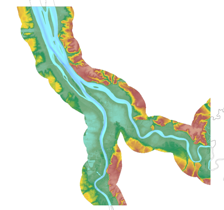
The update of the coastal topo-bathymetric DEM of the Gironde estuary - upstream with a resolution of 0.0002° (~ 20 m) was carried out in the third phase of the HOMONIM project. This DEM covers the upstream part of the Gironde estuary, from Pauillac to Bordeaux on the Garonne and to Libourne on the Dordogne. It is complementary to the DEM covering the downstream estuary (between Pauillac and the mouth of the Gironde). The DEM is intended to be implemented in hydrodynamic models in order to produce forecasts as accurate as possible of water heights and sea states at the coast to improve the relevance of the Wave-Submergence Vigilance. This product is available with either the Lowest Astronomic Tide (LAT) or the Mean Sea Level (MSL) as a vertical reference.