 Catalogue Shom
irregular
Type of resources
Available actions
Topics
Keywords
Provided by
Years
Formats
Representation types
Update frequencies
status
Scale
Resolution
-
This service allows users to view surface tidal current predictions calculated from the analysis of a high-resolution hydrodynamic simulation projected onto a 250 m grid. This service was built by Shom and funded by French CCI Métropolitaine Bretagne Ouest in the frame of the Atlantic Blue Port project of <a href="https://www.atlanticarea.eu" target="_blank">Interreg Atlantic Area</a> european program.
-

The "Military practice areas" product contains vector data in the form of 2D surface objects describing the military practice areas in the France sector represented on Zonex variants of nautical charts. This is the S-57 MIPARE object class (military practice areas): maritime zone within which military, naval or air exercises can take place.
-
This service allows users to view surface tidal current predictions calculated from the analysis of a high-resolution hydrodynamic simulation projected onto a 250 m grid. This service was built by Shom and funded by French CCI Métropolitaine Bretagne Ouest in the frame of the Atlantic Blue Port project of <a href="https://www.atlanticarea.eu" target="_blank">Interreg Atlantic Area</a> european program.
-
This service allows users to view surface tidal current predictions calculated from the analysis of a high-resolution hydrodynamic simulation projected onto a 500 m grid.
-
The Tidal stream atlas netcdf product – Seine Bay provides tidal current data for an area stretching from Fecamp at the east of the area to Cherbourg at the west. The product consists of two gridded files with different spatial resolutions covering the Seine Bay area (overall view at 500 m) and the geographical area of Le Havre harbour (250 m). The U and V velocities of the tidal currents depend on the tidal conditions considered at mean neap and spring tidal rates. The data are provided in m/s for the surface layer. The times are given in relation to high tide or low tide at the reference port chosen in the area and are provided from 6 hours before to 6 hours after that reference.
-
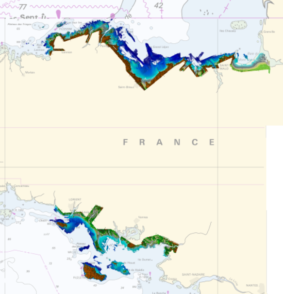
Product replaced by Litto3D - Brittany 2018-2021. https://services.data.shom.fr/geonetwork/srv/fre/catalog.search#/metadata/BATHYMETRIE_LITTO3D_BZH_2018_2021.xml
-
This service allows users to view surface tidal current predictions calculated from the analysis of a high-resolution hydrodynamic simulation projected onto a 250 m grid.
-
This service allows users to view surface tidal current predictions calculated from the analysis of a high-resolution hydrodynamic simulation projected onto a 2 km grid.
-
The Tidal stream atlas netcdf product – Seine Bay provides tidal current data for an area stretching from Fecamp at the east of the area to Cherbourg at the west. The product consists of two gridded files with different spatial resolutions covering the Seine Bay area (overall view at 500 m) and the geographical area of Le Havre harbour (250 m). The U and V velocities of the tidal currents depend on the tidal conditions considered at mean neap and spring tidal rates. The data are provided in m/s for the surface layer. The times are given in relation to high tide or low tide at the reference port chosen in the area and are provided from 6 hours before to 6 hours after that reference.
-
The Tidal stream atlas netcdf product provides tidal current data for an area stretching from the French coast, covering The English Channel and the Bay of Biscay. The product consists of gridded files with different spatial resolutions. The U and V velocities of the tidal currents depend on the tidal conditions considered at mean neap and spring tidal rates. The data are provided in m/s for the surface layer. The times are given in relation to high tide at the reference port chosen in the area and are provided from 6 hours before to 6 hours after that reference.