 Catalogue Shom
elevation
Type of resources
Available actions
Topics
Keywords
Provided by
Years
Formats
Representation types
Update frequencies
status
Scale
Resolution
-
Litto3D is a unique and continuous land-sea database which can provide 3D models of the shape and location of French coastal terrain. A line separates sea and land data acquisition zones, and the associated survey readings obtained using bathymetric lidar technologies or multibeam echosounders for sea readings and airborne lidar topographical surveys for land readings, with 300 m overlap. Litto3D digital models are available in two formats: a set of 3D points and a qualified terrain mesh.
-
The coastal topo-bathymetric DEM of Moorea with a resolution of 0.0002° (~ 20 m) was produced by the Shom for Météo-France (Inter-regional Direction in French Polynesia). This DEM covers the Moorea lagoons down to the 100 m isobath, in order to meet the need for modeling marine submersions in French Polynesia. It complements the bathymetric DEM of Tahiti and Moorea, with a resolution of 0.001° (~ 100 m). The vertical reference for this product is Mean Sea Level (MSL).
-
Litto3D is a unique and continuous land-sea database which can provide 3D models of the shape and location of French coastal terrain. A line separates sea and land data acquisition zones, and the associated survey readings obtained using bathymetric lidar technologies or multibeam echosounders for sea readings and airborne lidar topographical surveys for land readings, with 300 m overlap. Litto3D digital models are available in two formats: a set of 3D points and a qualified terrain mesh.
-

Litto3D is a unique and continuous land-sea database which provide 3D models of french coastal areas. Surveys are carried out by airborne lidar bathymetry over the sea side and airborne lidar topography over the land up to 2km inland. Litto3D digital models are available in two formats: a set of 3D points and a digital terrain model. The product "Litto3D - Brittany 2018-2021" covers the coastline and islands of Côtes d'Armor, Ille-et-Vilaine and Morbihan departments.
-
The coastal topo-bathymetric DEM was produced using the bathymetric and topographic data acquired between 2012 and 2015 by Shom and the PASSION programme team. The 20 m coastal grid covers the Passion atoll – Clipperton and the local flanks of the atoll to a depth of 1500 m. Passion island - Clipperton, in the eastern Pacific Ocean, is a remote uninhabited atoll over 5,000 km from Tahiti in French Polynesia and over 1,000 km from the Mexican coasts. Passion island is the highest point on the Clipperton ridge, and the only location above water level. This is the only coral atoll in the eastern Pacific in the northern hemisphere, at a longitude of W 109° and a latitude of N 10°.
-

Bathymetric datasets are an extraction of surveys belonging to the Shom public database. For depth up to 50m, the vertical precision of soundings varies from 30cm to 1m and the horizontal precision varies from 1 to 20m. In deep ocean, the vertical precision is mainly around 1 or 2% of the bottom depth. It is sometimes more, it depends on the technology used. The data are referenced to ZH which is assimilated to LAT. Data are corrected for sound velocity variations. <br /> October 27 2025 version
-
The high resolution Coastline corresponds to the Highest Astronomical Tide (HAT) with a tidal coefficient of 120 and in normal weather conditions (no sea breeze and mean atmospheric pressure of 1013 hPa).
-
Litto3D is a unique and continuous land-sea database which can provide 3D models of the shape and location of French coastal terrain. A line separates sea and land data acquisition zones, and the associated survey readings obtained using bathymetric lidar technologies or multibeam echosounders for sea readings and airborne lidar topographical surveys for land readings, with 300 m overlap. Litto3D digital models are available in two formats: a set of 3D points and a qualified terrain mesh.
-

The bathymetric DEM for the coasts of New-Caledonia with a resolution of 0.001° (~ 100 m) was prepared in the framework of a Shom-IRD partnership as part of the TSUCAL project. The DEM covers the basin from New Caledonia in the west to the Vanuatu archipelago in the east. The DEM is designed to be used in hydrodynamic models in order to improve the pertinence of the Waves-Submersion monitoring programme.
-
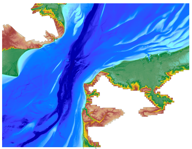
The coastal topo- bathymetric DEM for the coasts of the straight of Pas-de-Calais with a resolution of 0.0002° (~ 20 m) was prepared as part of the TANDEM project. The DEM covers the eastern Channel and southern North Sea, including the French coast of the Nord - Pas-de-Calais administrative department and part of the British coast, in the county of Kent, and the south part of the Thames estuary up to Rye. The DEM is designed to be implemented in the hydrodynamic models of the TANDEM project in order to estimate the coastal effects of tsunamis for the Atlantic and English Channel, where French nuclear power plants have been installed for about 30 years. This product is available with the Lowest Astronomic Tide (LAT) or the Mean Sea Level (MSL) as a vertical datum.