 Catalogue Shom
ArcGis Grid
Type of resources
Available actions
Topics
Provided by
Years
Formats
Representation types
Update frequencies
status
Scale
Resolution
-
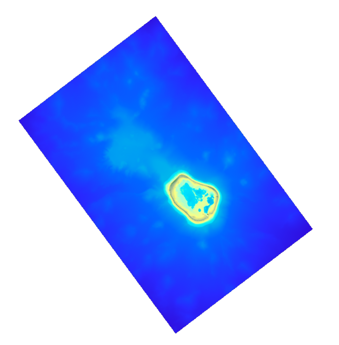
The coastal topo-bathymetric DEM was produced using the bathymetric and topographic data acquired between 2012 and 2015 by Shom and the PASSION programme team. The 20 m coastal grid covers the Passion atoll – Clipperton and the local flanks of the atoll to a depth of 1500 m. Passion island - Clipperton, in the eastern Pacific Ocean, is a remote uninhabited atoll over 5,000 km from Tahiti in French Polynesia and over 1,000 km from the Mexican coasts. Passion island is the highest point on the Clipperton ridge, and the only location above water level. This is the only coral atoll in the eastern Pacific in the northern hemisphere, at a longitude of W 109° and a latitude of N 10°.
-
Le produit bathymétrie de façade golfe du Lion – Côte d’Azur d'une résolution de 0.001° (~ 111 m) a été réalisé dans le cadre du projet HOMONIM. Il couvre l’intégralité de la façade métropolitaine méditerranéenne, du littoral jusqu’à environ 2800 m de profondeur. Le MNT est destiné à être implémenté dans les modèles hydrodynamiques afin de produire des prévisions aussi précises que possible des hauteurs d’eau et d’états de mer à la côte et donc d’améliorer la pertinence de la Vigilance Vagues-Submersion. La référence verticale de ce produit est le niveau moyen des mers.
-
Ce modèle bathymétrique (MNT) est le résultat de la compilation de données et modèles numériques antérieurs à 2008 dans la zone du Golfe de Gascogne. Le pas de la grille est de 1000 mètres. Accès tout public sous conditions.
-
Ce modèle bathymétrique (MNT) est le résultat de la synthèse de données bathymétrique et topographique de la Manche et de la marge du golfe de Gascogne antérieure à 2008. Le pas de la grille est de 500m. Accès tout public sous conditions.
-
The update of the coastal topo-bathymetric DEM of the Pertuis charentais at a resolution of 0.0002° (~ 20 m) was carried out in the third phase of the HOMONIM project. The DEM extends from the terrestrial domain to about 60 meters depth over all the pertuis (pertuis Breton, pertuis d’Antioche and pertuis of Maumusson). The DEM is intended to be implemented in hydrodynamic models in order to produce forecasts as accurate as possible of water heights and sea states at the coast to improve the relevance of the Wave-Submergence Vigilance. The vertical reference for this product is Mean Sea Level (MSL).
-
Le MNT topo-bathymétrique côtier du port de Saint-Malo et ses abords à une résolution de 0.00005° (~ 5 m) a été réalisé dans le cadre du PAPI Saint-Malo. Le MNT englobe la ville de Saint-Malo et ses abords, depuis la pointe du Décollé à l'Ouest jusqu'à la pointe de la Varde à l'Est. Le MNT est destiné à être implémenté dans les modèles hydrodynamiques afin de produire des prévisions aussi précises que possible des hauteurs d’eau et d’états de mer à la côte et donc d’améliorer la gestion du risque de submersion marine.
-
The coastal topo- bathymetric DEM for the coasts of Morbihan with a resolution of 0.0002° (~ 20 m) was prepared as part of the TANDEM project (Programme Investissements d'Avenir, ANR-11-RSNR-00023-01). It covers the French administrative department of Morbihan and part of Loire-Atlantique. This DEM runs from the Gâvres peninsula in the north west to La Baule in the south east and covers the Gulf of Morbihan, the Quiberon bay and peninsula, Houat, Hoëdic and Belle-Ile islands and the Vilaine estuary. The DEM is designed to be implemented in the hydrodynamic models of the TANDEM project in order to estimate the coastal effects of tsunamis for the Atlantic and English Channel, where French nuclear power plants have been installed for about 30 years. This product is available with the Lowest Astronomic Tide (LAT) or the Mean Sea Level (MSL) as a vertical datum.
-

The bathymetric DEM of Tahiti and Moorea with a resolution of 0.001° (~ 100 m) was produced by the Shom for Météo-France (Inter-regional Direction in French Polynesia). This DEM covers a 10 km radius around the islands of Tahiti and Moorea in order to meet the need for marine submersions modelling in French Polynesia. This product is available at different vertical references, either the lowest astronomical tide (LAT) or the mean sea level (MSL).
-
Le MNT topo-bathymétrique côtier d'une partie du golfe normand-breton à une résolution de 0.0002° (~ 20 m) a été réalisé dans le cadre du PAPI Saint-Malo. Le MNT englobe le plateau des Minquiers au Nord-Ouest jusqu'à la baie du Mont-Saint-Michel au Sud-Est. Le MNT est destiné à être implémenté dans les modèles hydrodynamiques afin de produire des prévisions aussi précises que possible des hauteurs d’eau et d’états de mer à la côte et donc d’améliorer la gestion du risque de submersion marine.
-
Modèle bathymétrique (MNT) de la Zone de Protection Ecologique de Méditerranée. Les données bathymétriques dont la profondeur est supérieure à 200 m (au delà du rebord du plateau continental) proviennent des levés par sondeurs multifaisceau de l'IFREMER. Les données du plateau continental (inférieures à 200 m) proviennent des levés hydrographiques et de la base de données du SHOM. Le pas de la grille est de 250 mètres.