 Catalogue Shom
boundaries
Type of resources
Available actions
Topics
Keywords
Contact for the resource
Provided by
Years
Formats
Representation types
Update frequencies
Scale
-
The Regulation (EU) No 1380/2013 of European Parliament and Council of 11 December 2013, in its second paragraph of Article 5, authorises Member States to establish coastal waters along its coasts. Those areas enable member States to restrain fisheries to specific species to specific Member States following precise rules (quotas, limited fishery season). The description of the French coastal waters is established in Part 6 of Appendix 1. The coastal waters extend from 6 nautical miles from in force baselines to 12 nautical miles from in force baselines. Only portions of the French coasts are concerned.
-
Title V of Volume IX of rural and sea fisheries laws defines the measures related to Overseas territories. Articles R951-14 and R953-5 in particular define for specific Overseas territories a limit located at 100 nautical miles from the in force baselines. Inside this limit, fisheries are limited to the ships registered in the ports of those Overseas territories, except dispensation allowed by State. Those restrictions are not applied to ships registered in the European Union which are traditionally fishing in those waters, as long as they do not exceed the fisheries effort which is traditionally applied.
-
The regulatory part of Volume IX of rural and sea fisheries laws is defined by the decree No 2014-1608 of 26 December 2014. In particular, Article D922-16 of the appendix to the decree defines a limit related to fisheries located at 3 nautical miles from the low waterline of the continent and islands and islets which are always dry. In the particular case of Mayotte Island, in compliance with Article 61 of the prefectural decree No 2018-681 of 30 July 2018 which regulates the exercise of sea fisheries at Mayotte department, this limits is located at 3 nautical miles from the in force baselines.
-
The combined error grid of the SIO V31 gravity anomaly model (D. T. Sandwell, H. Harper, B. Tozer et al., Gravity field recovery from geodetic altimeter missions, Advances in Space Research, https://doi.org/10.1016/j.asr.2019.09.011) is computed with a method described in a paper submitted to Earth and Space Science (AGU). The model’s extension is North Atlantic.
-
The United Nations Convention on the law of the sea (UNCLOS) introduced a new definition of the continental shelf which can extend “to the outer edge of the continental margin, or to a distance of 200 nautical miles from the baselines from which the breadth of the territorial sea is measured where the outer edge of the continental margin does not extend up to that distance.” Coastal States can thus have a continental shelf of 200 nautical miles even in the absence of a geomorphological continental shelf, and a continental shelf extending beyond that limit where the presence of certain geomorphological and sedimentary criteria have been recognized by the Commission on the Limits of the Continental Shelf (CLCS). The rights coastal State can exercise over the continental shelf are specified in Part VI of the UNCLOS. These rights are sovereign and exclusive over the seabed and subsoil, for exploration and exploitation of natural mineral, fossil and biological resources. The French authorities also hold competence recognized by the UNCLOS for: - construction, operation and use of artificial islands and installations; - marine scientific research; - issuing consent for the course of any pipeline; - issuing consent for the course of cables installed or used for exploitation of the continental shelf or of its resources.
-
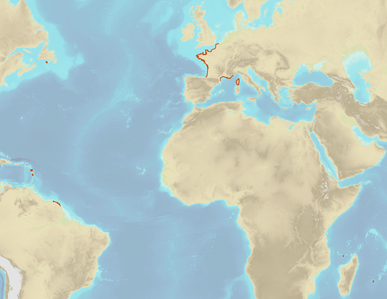
French Ministry of Culture / DRASSM – Shom The product "Limit of preventive archeology licence fee" contains the limits for the preventive archeology licence fee (1 nautical mile) as defined in the French Heritage Code. This limit is managed by the Department of Underwater Archeological Research (DRASSM) of the Ministry of Culture. This limit, defined by the Heritage Code at 1 nautical mile from the low-water line, permits to delineate the areas where the licence fee for preventive archeology at sea is applied. In Mainland France in the Gironde estuary, the limit for the preventive archeology licence fee is stopped by the crosswise limit of the sea as defined by the decree of 26 August 1857. In French Guiana, the limit for the preventive archeology licence fee is stopped in Maroni and Oyapock rivers by the crosswise limits of the sea respectively defined the order of 30 January 1991 and the order No 863 of 26 May 1986, until meeting the land boundary which delineates the rivers with the neighbouring States. The product "Limit of preventive archeology licence fee" is to use in addition to the digital product “Maritime Limits and Boundaries” of Shom (French: “Délimitations maritimes”) which represents the limits of the French maritime spaces of sovereignty or jurisdiction through the World. The product “Maritime Limits and Boundaries” (French: “Délimitations maritimes”) can be viewed on data.shom.fr (Maritime boundaries Category) and downloaded on the French national portal of maritime limits (https://maritimelimits.gouv.fr).
-
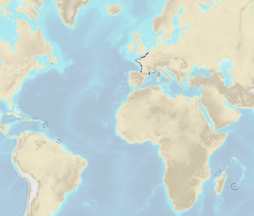
The theme "Agreed maritime boundaries" contains the delineation limits between maritime spaces under sovereignty or jurisdiction of France et neighbouring States which are established by ratification of a boundary agreement or by a decision of an arbitral tribunal or an international legal body entitled to deal with cases relating to the Law of the Sea.
-
In the Law of the Sea, the continental shelf located beyond 200 nautical miles affects the seabed and its subsoil on which the coastal State exerts sovereign rights for purposes of exploration and exploitation of its natural ressources. In those areas, the wealth generated by the exploitation of the natural ressources are shared via the International Seabed Authority between the States which have signed UNCLOS (in particular with the developping States or the ones which do not have access to the sea). The outer limit of the continental shelf beyond 200 nautical miles is determined in compliance with the criterias of Article 76 of UNCLOS and notably by the examination of a submission deposited by the Coastal State to the Commission for the Limits of the Continental Shelf (CLCS). the outer limit of the French continental shelf beyond 200 nautical miles is the final result of the national program EXTRAPLAC after the adoption of recommandations by CLCS, the delineation of the attributed areas with neighbouring States if necessary and the publication by decree. The theme "Outer limit of the continental shelf beyond 200 nautical miles" gathers the limits of the extended continental shelf which has been recommended by CLCS and published by a decree of the French Republic.
-

The "Sovereignty and jurisdiction maritime spaces of France" product contains the areas of sovereignty and jurisdiction maritime spaces of France all around the world.<br /><br /> It is constituted of 2D areas objects split into four categories :<br /> - the territorial sea (from baselines to a distance of 12 nautical miles or to maritime boundaries with neighbouring countries);<br /> - the contiguous zone (from 12 nautical miles to 24 nautical miles from the baselines or to maritime boundaries with neighbouring countries);<br /> - the exclusive economic zone (EEZ) (from 12 nautical miles to 200 nautical miles from the baselines or to maritime boundaries with neighbouring countries);<br /> - the continental shelf over the 200 nautical miles limit (from 200 nautical miles from the baselines to the limits recommended by the Commission on the Limits of the Continental Shelf (CLCS) or to the maritime boundaries with neighbouring countries).<br /> Internal waters, which constitute a space of sovereignty beyond the baselines, are not included in the "Sovereignty and jurisdiction maritime spaces of France" product.<br /> The "Sovereignty and jurisdiction maritime spaces of France" product may not be considered as an enforceable right. Only the “Maritime limits and boundaries” product, that can be displayed and interrogated on the website data.shom.fr (maritime boundaries category) and also downloaded on the French national portal of maritime limits (https://maritimelimits.gouv.fr), may be considered so.<br /><br /> December 2022 version.
-
French Ministry of Agriculture and Food / DRASSM - Shom<br /> The product "Limits related to fishery uses" contains the limits related to fishery uses as defined in the French or European legislations. Those limits are managed by the Directorate for Sea Fisheries and Aquaculture (DPMA) of the Ministry of Agriculture and Food. <br /> Those limits are divided into three categories : <br /> - the inner limit of the coastal waters (6 nautical miles) ; <br /> - the 3-nautical-mile limit ; <br /> - the limit of fisheries for overseas territories (100 nautical miles).<br /><br /> The product "Limits related to fishery uses" is to use in addition to the digital product “Maritime Limits and Boundaries” of Shom (French: “Délimitations maritimes”) which represents the limits of the French maritime spaces of sovereignty or jurisdiction through the World.<br /> The product “Maritime Limits and Boundaries” (French: “Délimitations maritimes”) can be viewed on data.shom.fr (Maritime boundaries Category) and downloaded on the French national portal of maritime limits (https://maritimelimits.gouv.fr).