 Catalogue Shom
GRD
Type of resources
Available actions
Topics
Provided by
Years
Formats
Representation types
Update frequencies
status
Resolution
-
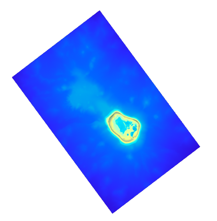
The coastal topo-bathymetric DEM was produced using the bathymetric and topographic data acquired between 2012 and 2015 by Shom and the PASSION programme team. The 20 m coastal grid covers the Passion atoll – Clipperton and the local flanks of the atoll to a depth of 1500 m. Passion island - Clipperton, in the eastern Pacific Ocean, is a remote uninhabited atoll over 5,000 km from Tahiti in French Polynesia and over 1,000 km from the Mexican coasts. Passion island is the highest point on the Clipperton ridge, and the only location above water level. This is the only coral atoll in the eastern Pacific in the northern hemisphere, at a longitude of W 109° and a latitude of N 10°.
-
Le produit bathymétrie de façade golfe du Lion – Côte d’Azur d'une résolution de 0.001° (~ 111 m) a été réalisé dans le cadre du projet HOMONIM. Il couvre l’intégralité de la façade métropolitaine méditerranéenne, du littoral jusqu’à environ 2800 m de profondeur. Le MNT est destiné à être implémenté dans les modèles hydrodynamiques afin de produire des prévisions aussi précises que possible des hauteurs d’eau et d’états de mer à la côte et donc d’améliorer la pertinence de la Vigilance Vagues-Submersion. La référence verticale de ce produit est le niveau moyen des mers.
-
Le MNT topo-bathymétrique côtier du port de Saint-Malo et ses abords à une résolution de 0.00005° (~ 5 m) a été réalisé dans le cadre du PAPI Saint-Malo. Le MNT englobe la ville de Saint-Malo et ses abords, depuis la pointe du Décollé à l'Ouest jusqu'à la pointe de la Varde à l'Est. Le MNT est destiné à être implémenté dans les modèles hydrodynamiques afin de produire des prévisions aussi précises que possible des hauteurs d’eau et d’états de mer à la côte et donc d’améliorer la gestion du risque de submersion marine.
-

The bathymetric DEM of Tahiti and Moorea with a resolution of 0.001° (~ 100 m) was produced by the Shom for Météo-France (Inter-regional Direction in French Polynesia). This DEM covers a 10 km radius around the islands of Tahiti and Moorea in order to meet the need for marine submersions modelling in French Polynesia. This product is available at different vertical references, either the lowest astronomical tide (LAT) or the mean sea level (MSL).
-
Le MNT topo-bathymétrique côtier d'une partie du golfe normand-breton à une résolution de 0.0002° (~ 20 m) a été réalisé dans le cadre du PAPI Saint-Malo. Le MNT englobe le plateau des Minquiers au Nord-Ouest jusqu'à la baie du Mont-Saint-Michel au Sud-Est. Le MNT est destiné à être implémenté dans les modèles hydrodynamiques afin de produire des prévisions aussi précises que possible des hauteurs d’eau et d’états de mer à la côte et donc d’améliorer la gestion du risque de submersion marine.
-
Le MNT bathymétrique de façade de la Guadeloupe et de la Martinique à une résolution de 0.001° (~ 100 m) a été réalisé dans le cadre du projet HOMONIM. Le MNT englobe une partie des îles des petites Antilles, depuis Montserrat au nord jusqu’à Sainte-Lucie au sud. Il s’étend au large jusqu’à 5800 m de profondeur. Le MNT est destiné à être implémenté dans les modèles hydrodynamiques afin de produire des prévisions aussi précises que possible des hauteurs d’eau et d’états de mer à la côte et donc d’améliorer la pertinence de la Vigilance Vagues-Submersion.
-
Le produit topo-bathymétrique côtier de la baie de Saint-Jean-de-Luz et ses abords, à une resolution de 0.0002° (~20 m), a été réalisé dans le cadre du projet TANDEM. Il couvre un territoire comprenant la baie de Saint-Jean-de-Luz et ses abords immediats. Ce MNT est destiné à être implémenté dans les modèles hydrodynamiques du projet TANDEM afin d'estimer les effets côtiers des tsunamis pour l’Atlantique et la Manche, où sont installées les centrales nucléaires françaises depuis environ 30 ans. La référence verticale de ce produit est le niveau des plus basses mers astronomiques.
-
Le MNT topo-bathymétrique côtier du port de Saint-Malo et ses abords à une résolution de 0.00005° (~ 5 m) a été réalisé dans le cadre du PAPI Saint-Malo. Le MNT englobe la ville de Saint-Malo et ses abords, depuis la pointe du Décollé à l'Ouest jusqu'à la pointe de la Varde à l'Est. Le MNT est destiné à être implémenté dans les modèles hydrodynamiques afin de produire des prévisions aussi précises que possible des hauteurs d’eau et d’états de mer à la côte et donc d’améliorer la gestion du risque de submersion marine.
-
Le produit bathymétrie de façade Corse d'une résolution de 0.001° (~ 111 m) a été réalisé dans le cadre du projet HOMONIM. Il couvre l’intégralité de la marge Corse, du littoral jusqu’à environ 3000 m de profondeur. Le MNT est destiné à être implémenté dans les modèles hydrodynamiques afin de produire des prévisions aussi précises que possible des hauteurs d’eau et d’états de mer à la côte et donc d’améliorer la pertinence de la Vigilance Vagues-Submersion. La référence verticale de ce produit est le niveau moyen des mers.
-
Le MNT topo-bathymétrique côtier de l'Île de La Passion – Clipperton à une résolution de 20 m a été réalisé en valorisant les données bathymétriques et topographiques acquises entre 2012 et 2015 par le Shom et l'équipe du programme PASSION. La grille côtière à 20 m comprend l'atoll de La Passion – Clipperton et ses flancs immédiats jusqu'à environ 1500 m de profondeur. L'Île de La Passion - Clipperton, située dans l'Océan pacifique Est, est un atoll inhabité isolé à plus de 5000 km de Tahiti en Polynésie Française et plus de 1000 km des côtes mexicaines. L'île est le point culminant, et le seul émergé, de la dorsale de Clipperton. Il s'agit du seul atoll corallien du Pacifique oriental situé dans l'hémisphère nord, par 109°de longitude Ouest et 10° de latitude Nord.