 Catalogue Shom
irregular
Type of resources
Available actions
Topics
Keywords
Provided by
Years
Formats
Representation types
Update frequencies
status
Scale
Resolution
-
Litto3D is a unique and continuous land-sea database which can provide 3D models of the shape and location of French coastal terrain. A line separates sea and land data acquisition zones, and the associated survey readings obtained using bathymetric lidar technologies or multibeam echosounders for sea readings and airborne lidar topographical surveys for land readings, with 300 m overlap. Litto3D digital models are available in two formats: a set of 3D points and a qualified terrain mesh.
-

Litto3D provides 3D, continuous sea-land description of French coastal areas. Data is acquired by airborne topo-bathymetric LiDARs. Litto3D products come in 3D point clouds and digital terrain models formats. The product "Litto3D - Nouvelle-Aquitaine 2020-2022" covers the geographical area from the Charente-Maritime to the Spanish border. For the maritime part, the data produced by Shom extend offshore down to signal extinction, approximatively 20 depth when environmental conditions are optimal. On land, the data are truncated at a limit that ensures the product retain its coastal character.
-
The “French sub-rectangles of the ICES fishery statistical rectangles” product contains 2D areas vector objects representing a sub-rectangle division of ICES statistical rectangles. Each product polygon belongs to an unique ICES rectangle. This subdivision enables distinction between overlapping areas in two or more EEZs, areas of functional interest and areas of regulatory interest.
-

Litto3D is a unique and continuous land-sea database which can provide 3D models of the shape and location of French coastal terrain. A line separates sea and land data acquisition zones, and the associated survey readings obtained using bathymetric lidar technologies or multibeam echosounders for sea readings and airborne lidar topographical surveys for land readings, with 300 m overlap. Litto3D digital models are available in two formats: a set of 3D points and a qualified terrain mesh.
-
Lidar marine product is a unique and continuous land-sea database which can provide 3D models of the shape and location of french coastal terrain. Surveys are carried out by airborne lidar bathymetry over the sea side and airborne lidar topography over the land side up to 400m inland. This marine product is available in two formats: a set of 3D points and a qualified terrain mesh.
-
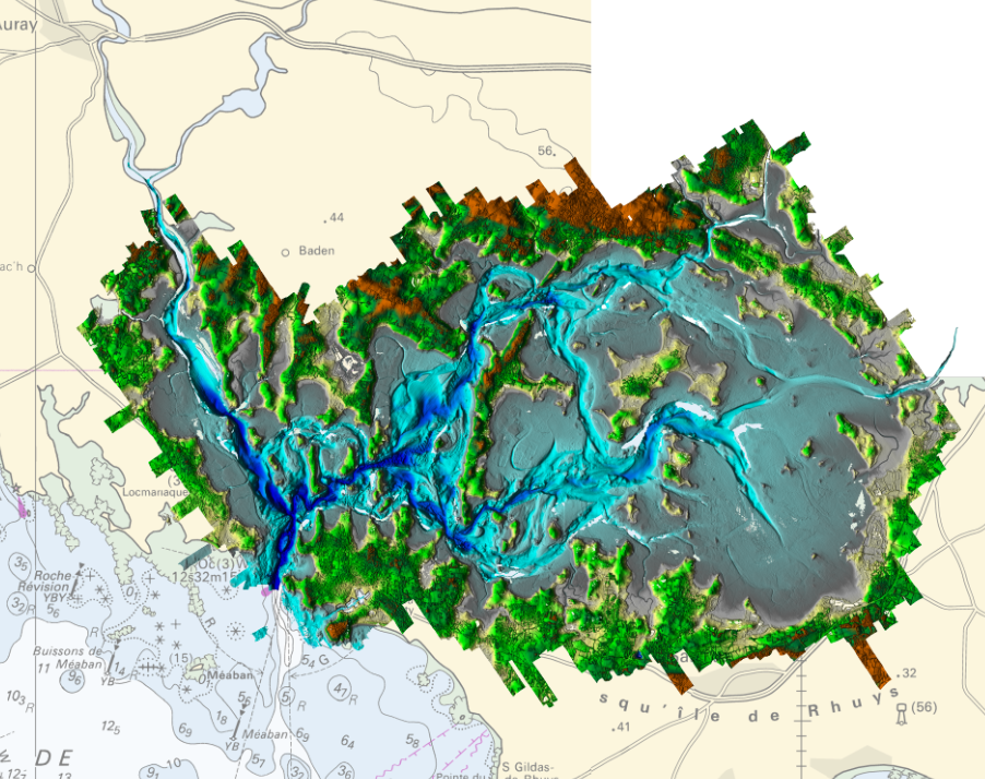
Litto3D Marine Part is an intermediate product of the Litto3D product containing only marine data.Litto3D is a unique and continuous land-sea database which can provide 3D models of the shape and location of French coastal terrain. A line separates sea and land data acquisition zones, and the associated survey readings obtained using bathymetric lidar technologies or multibeam echosounders for sea readings and airborne lidar topographical surveys for land readings, with 300 m overlap. Litto3D digital models are available in two formats: a set of 3D points and a qualified terrain mesh.
-

The "Military practice areas" product contains vector data in the form of 2D surface objects describing the military practice areas in the France sector represented on Zonex variants of nautical charts. This is the S-57 MIPARE object class (military practice areas): maritime zone within which military, naval or air exercises can take place.
-

Bathymetric datasets are an extraction of surveys belonging to the Shom public database. For depth up to 50m, the vertical precision of soundings varies from 30cm to 1m and the horizontal precision varies from 1 to 20m. In deep ocean, the vertical precision is mainly around 1 or 2% of the bottom depth. It is sometimes more, it depends on the technology used. The data are referenced to ZH which is assimilated to LAT. Data are corrected for sound velocity variations. <br /> October 27 2025 version
-
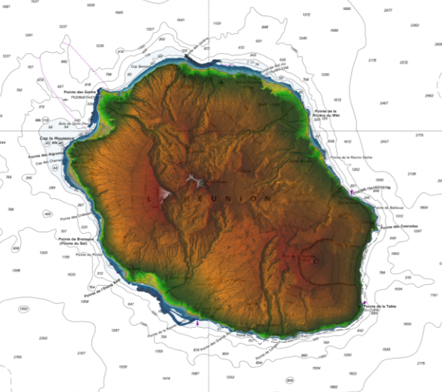
Litto3D is a unique and continuous land-sea database which can provide 3D models of the shape and location of French coastal terrain. A line separates sea and land data acquisition zones, and the associated survey readings obtained using bathymetric lidar technologies or multibeam echosounders for sea readings and airborne lidar topographical surveys for land readings, with 300 m overlap. Litto3D digital models are available in two formats: a set of 3D points and a qualified terrain mesh.
-
Marine toponymy data layer obtained from French ENC and created using the S23 (4th edition, June 2002). Note: The usual Sea of Japan designation does not imply taking a stand in the dispute between Korea, which names this sea "East Sea", and Japan, which names it "Sea of Japan".