Surface currents - HF radar (archives)
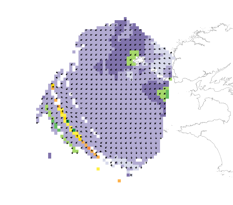
As part of the VIGICOTE project, which forms part of coastal surveillance and government operations at sea, a system comprising two WERA high-frequency radars was installed in 2006 by Actimar on behalf of Shom at the sites of Pointe de Garchine in Porspoder and Pointe de Brézellec in Cléden-Cap-Sizun.
These radars have enabled geophysical measurements in the Iroise Sea to improve and validate hydrodynamic models in this area. This HF radar system makes it possible to map surface ocean currents continuously over long periods. The radars were configured for a maximum range of 150 km, a spatial resolution of 1.5 km (transmitting at 12 MHz) and a temporal resolution of 10 minutes.
Between 2015 and January 2021, Shom collected and disseminated these surface current observations in the Iroise Sea in near real time. Following this period, the HF radar systems are no longer operated by Shom: the measurements are no longer available on data.shom.fr. The archives of these measurements can be downloaded in NetCDF format (daily files) for the period from 1 January 2015 to 31 January 2021 and constitute the "Surface Currents - HF Radar" product.
|
|
Citation proposal
. Surface currents - HF radar (archives). https://services.data.shom.fr:/geonetwork/functions/api/records/OCEANO_MODELE_RADARHF.xml |
Simple
- Date ( Creation )
- 2015-01-01
- Identifier
- Presentation form
- Digital map
- Credit
-
©Shom et Actimar
Owner
- Maintenance and update frequency
- Not planned
- Keywords ( Theme )
-
-
observation
-
oceanography
-
HF radar
-
open data
-
Product
-
- GEMET - INSPIRE themes, version 1.0 ( Theme )
- Use limitation
-
Data may be freely used providing that the source is mentioned as follows : "Shom. Surface currents - HF radar. https://dx.doi.org/10.17183/RADARHF_OBS ". Open licence Etalab v. 2.0 avril 2017.
- Use limitation
-
Do not use for navigation.
- Use limitation
-
Surface current observations obtained using HF radar have been automatically post-processed and have not been reviewed or validated by oceanographers. They should therefore be used with an awareness of the margins of error associated with this methodology, and their use remains the responsibility of the user.
- Use limitation
-
Data may be freely used providing that the source is mentioned as follows : "Shom. Surface currents - HF radar. https://dx.doi.org/10.17183/RADARHF_OBS ". Open licence Etalab v. 2.0 avril 2017.
- Use limitation
-
Do not use for navigation.
- Use limitation
-
Surface current observations obtained using HF radar have been automatically post-processed and have not been reviewed or validated by oceanographers. They should therefore be used with an awareness of the margins of error associated with this methodology, and their use remains the responsibility of the user.
- Access constraints
- License
- Use constraints
- Other restrictions
- Other constraints
- Licence Ouverte version 2.0 Open Licence version 2.0
- Access constraints
- Other restrictions
- Other constraints
- Pas de restriction d'accès public. No public access restrictions.
- Classification
- Unclassified
- Spatial representation type
- Grid
- Metadata language
- fre French
- Character set
- utf8 UTF8
- Topic category
-
- Oceans
))
- Begin date
- 2015-01-01T00:00:00
- End date
- 2021-01-31T23:59:59
- Distribution format
-
-
NetCDF
(4
)
-
Distributor
- OnLine resource
-
Shom Geoportal
Shom Geoportal
- OnLine resource
-
Shom marketplace
Shom marketplace
- Hierarchy level
- Series
Conformance result
- Date ( Publication )
- 2010-11-23
- Explanation
-
Information sur la conformité au règlement d'interopérabilité des séries et des services de données géographiques.
- Pass
- true
Conformance result
- Date ( Publication )
- 2013-12-10
- Explanation
-
Information on the compliance of the resource with a specification (INSPIRE).
- Pass
- true
- Statement
-
Between 2015 and January 2021, Shom collected and disseminated these surface current observations in the Iroise Sea in near real time. Following this period, the HF radar systems are no longer operated by Shom: the measurements are no longer available on data.shom.fr.
Metadata
- File identifier
- OCEANO_MODELE_RADARHF.xml XML
- Metadata language
- fre French
- Character set
- utf8 UTF8
- Hierarchy level
- Series
- Hierarchy level name
-
Collection de données
- Date stamp
- 2026-07-07T17:49:25
- Metadata standard name
-
ISO 19115:2003/19139
- Metadata standard version
-
1.0
Point of contact
Overviews
Provided by