Search and Rescue Areas (SAR)
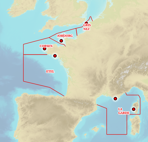
Information layer containing the SAR Zones (Search and Rescue). This layer contains a description of the French search and rescue (SAR) areas and the location of the associated Maritime Rescue Coordination Center (MRCC).
it covers the areas of responsibility of France.
The layer was produced by the Shom pursuant to the Circular Circular of the International Maritime Organization (IMO No. SAR.8 / Circ.4 of 1 December 2012).
|
|
Citation proposal
. Search and Rescue Areas (SAR). https://services.data.shom.fr:/geonetwork/WebService/api/records/BDML_SAR.xml |
Simple
- Date ( Creation )
- 2018-11-09
- Identifier
Owner
- Maintenance and update frequency
- Irregular
- Keywords ( Theme )
-
-
maritime surveillance
-
rescue at sea
-
state action at sea
-
AEM
-
product
-
open data
-
- GEMET - INSPIRE themes, version 1.0 ( Theme )
- Use limitation
-
Data free of use by acknowledging its source. Open licence Etalab v. 2.0 avril 2017.
- Use limitation
-
Do not use for navigation
- Use limitation
-
The data cannot replace reference texts and official nautical charts in the event of a dispute.
- Use limitation
-
Data free of use by acknowledging its source. Open licence Etalab v. 2.0 avril 2017.
- Use limitation
-
Do not use for navigation
- Use limitation
-
The data cannot replace reference texts and official nautical charts in the event of a dispute.
- Access constraints
- License
- Use constraints
- Other restrictions
- Other constraints
- Licence Ouverte version 2.0 Open Licence version 2.0
- Access constraints
- Other restrictions
- Other constraints
- Pas de restriction d'accès public. No public access restrictions.
- Classification
- Unclassified
- Spatial representation type
- Vector
- Metadata language
- fre French
- Character set
- utf8 UTF8
- Topic category
-
- Boundaries
))
- Distribution format
-
-
SHP
(-
) -
GML
(3.2
)- Specification
-
-
-
Point of contact
- OnLine resource
- Shom geoportal
- OnLine resource
- SAR_PYR_PNG_3857_WMSR
- OnLine resource
- Download service
- Hierarchy level
- Dataset
Conformance result
- Date ( Publication )
- 2010-11-23
- Explanation
-
Information sur la conformité au règlement d'interopérabilité des séries et des services de données géographiques.
- Pass
- true
- Statement
-
Numerical translation of points and limits relating to maritime surveillance useful for the action of the state at sea (French surveillance zones).
Metadata
- File identifier
- BDML_SAR.xml XML
- Metadata language
- French
- Character set
- UTF8
- Hierarchy level
- Dataset
- Hierarchy level name
-
Produit
- Date stamp
- 2019-10-25T00:00:00
- Metadata standard name
-
ISO 19115:2003/19139
- Metadata standard version
-
1.0
Point of contact
Overviews
Provided by