Harbour information
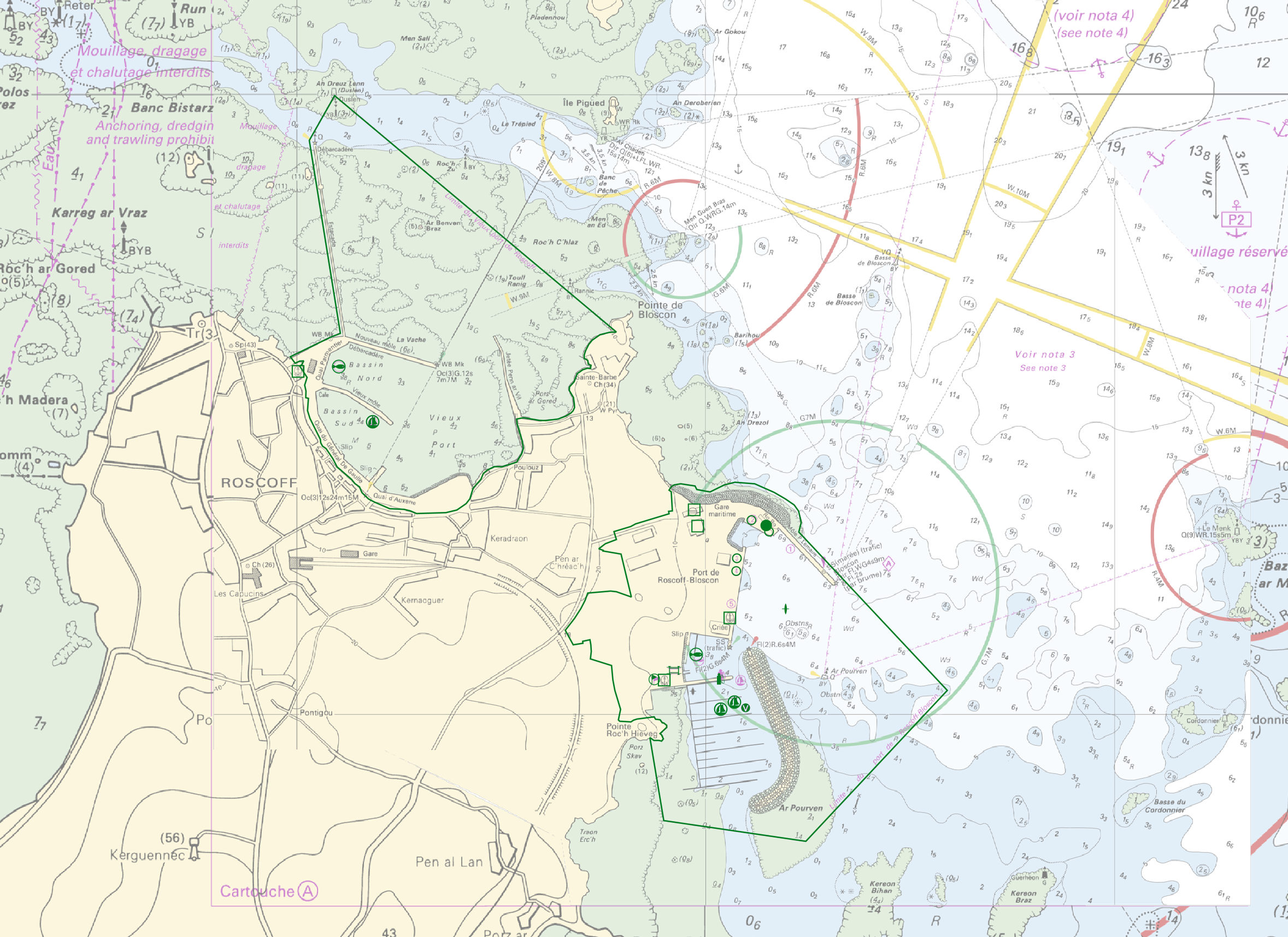
"Harbour Information" product contains 13 object classes, the acronyms used are those of IHO standard S-57 - International Hydrographic Organization – ( https://iho.int/ ):
- Berth (BERTHS): place in which a ship is moored at wharf
- Isolated building localizing a harbour office (BUISGL)
- Checkpoint (CHKPNT)
- Crane (CRANES)
- Floating dock (FLODOC): floating structure of one or more sections which can be partly submerged by controlled flooding to receive a vessel, then raised by pumping out the water so that the vessel's bottom can be exposed for maintenance.
- Gridiron (GRIDRN): structure in the intertidal zone serving as a support for vessels at low tide to permit work on the exposed portion of the vessel's hull.
- Harbour area (HRBARE) : administrative area of a port, including all docking and handling facilities, as well as short-term storage facilities.
- Harbour facility (HRBFAC)
- Hulk (HULKES) : hull of a wrecked or condemned ship, from which the fittings and superstructure have usually been removed, which is moored in a permanent position or grounded.
- Oil barrier (OILBAR)
- Pilot boarding place (PILBOP)
- Rescue station (RSCSTA)
- Small craft facility (SMCFAC)
Detailed definitions of each of these object classes can be found in the S-57 standard ( https://iho.int/en/standards-and-specifications ).
An online catalog is available at http://www.s-57.com/ .
Some of the symbols used for display on data.shom.fr portal have been adapted from icons from the OpenSeaMap open library ( https://github.com/OpenNauticalChart/ ).
|
|
Citation proposal
. Harbour information. https://services.data.shom.fr:/geonetwork/srv/api/records/BDML_PORTS.xml |
Simple
- Date ( Creation )
- 2021-06-16
- Identifier
- Credit
-
©Shom
Point of contact
- Maintenance and update frequency
- Irregular
- Keywords ( Theme )
-
-
harbour
-
anchorage
-
berth
-
pilot
-
BERTHS
-
BUISGL
-
CHKPNT
-
CRANES
-
FLODOC
-
GRIDRN
-
HRBARE
-
HRBFAC
-
HULKES
-
OILBAR
-
PILBOP
-
RSCSTA
-
SMCFAC
-
Product
-
Open data
-
- GEMET - INSPIRE themes, version 1.0 ( Theme )
- INSPIRE Spatial scope
- High-value dataset categories
- High-value dataset categories
- Use limitation
-
Data may be freely used providing that the source is mentioned as follows "Shom, 2021. Harbour information". Open licence Etalab v. 2.0 avril 2017.
- Use limitation
-
Do not use for navigation
- Use limitation
-
Data may be freely used providing that the source is mentioned as follows "Shom, 2021. Harbour information". Open licence Etalab v. 2.0 avril 2017.
- Use limitation
-
Do not use for navigation
- Access constraints
- License
- Use constraints
- Other restrictions
- Other constraints
- Licence Ouverte version 2.0 Open Licence version 2.0
- Access constraints
- Other restrictions
- Other constraints
- Pas de restriction d'accès public. No public access restrictions.
- Classification
- Unclassified
- Spatial representation type
- Vector
- Metadata language
- fre French
- Character set
- utf8 UTF8
- Topic category
-
- Transportation
))
- Distribution format
-
-
SHP
(inapplicable
)
-
Point of contact
- OnLine resource
-
Shom Geoportal
Shom Geoportal
- OnLine resource
- INFORMATIONS_PORTUAIRES_BDD_WMSV
- OnLine resource
- INFORMATIONS_PORTUAIRES_BDD_WFS:berths_point
- OnLine resource
- INFORMATIONS_PORTUAIRES_BDD_WFS:buisgl_point
- OnLine resource
- INFORMATIONS_PORTUAIRES_BDD_WFS:chkpnt_point
- OnLine resource
- INFORMATIONS_PORTUAIRES_BDD_WFS:cranes_point
- OnLine resource
- INFORMATIONS_PORTUAIRES_BDD_WFS:cranes_polygon
- OnLine resource
- INFORMATIONS_PORTUAIRES_BDD_WFS:flodoc_polygon
- OnLine resource
- INFORMATIONS_PORTUAIRES_BDD_WFS:gridrn_polygon
- OnLine resource
- INFORMATIONS_PORTUAIRES_BDD_WFS:hrbare_polygon
- OnLine resource
- INFORMATIONS_PORTUAIRES_BDD_WFS:hrbfac_point
- OnLine resource
- INFORMATIONS_PORTUAIRES_BDD_WFS:hrbfac_polygon
- OnLine resource
- INFORMATIONS_PORTUAIRES_BDD_WFS:hulkes_polygon
- OnLine resource
- INFORMATIONS_PORTUAIRES_BDD_WFS:oilbar_line
- OnLine resource
- INFORMATIONS_PORTUAIRES_BDD_WFS:pilbop_point
- OnLine resource
- INFORMATIONS_PORTUAIRES_BDD_WFS:rscsta_point
- OnLine resource
- INFORMATIONS_PORTUAIRES_BDD_WFS:smcfac_point
- OnLine resource
- INFORMATIONS_PORTUAIRES_BDD_WFS:smcfac_polygon
- OnLine resource
- Download link Harbours
- OnLine resource
-
Shom marketplace
Shom marketplace
- Hierarchy level
- Dataset
Conformance result
- Date ( Publication )
- 2010-11-23
- Explanation
-
Information sur la conformité au règlement d'interopérabilité des séries et des services de données géographiques.
- Pass
- true
Conformance result
- Date ( Publication )
- 2014-04-17
- Explanation
-
Information sur la conformité de la ressource à une spécification (INSPIRE).
- Pass
- false
Conformance result
- Date ( Publication )
- 2013-12-10
- Explanation
-
Information sur la conformité de la ressource à une spécification (INSPIRE).
- Pass
- false
Conformance result
- Date ( Publication )
- 2013-12-10
- Explanation
-
Information sur la conformité de la ressource à une spécification (INSPIRE).
- Pass
- false
- Statement
-
The information used in the elaboration of this product has been collected by Shom from various sources. It is based on Shom's knowledge of the marine environment and is used in the preparation of its products, including nautical charts.
Metadata
- File identifier
- BDML_PORTS.xml XML
- Metadata language
- fre French
- Character set
- UTF8
- Hierarchy level
- Dataset
- Hierarchy level name
-
Produit
- Date stamp
- 2021-06-24T16:28:27
- Metadata standard name
-
ISO 19115:2003/19139
- Metadata standard version
-
1.0
Point of contact
Overviews
Provided by