Worldwide seabed sediment map
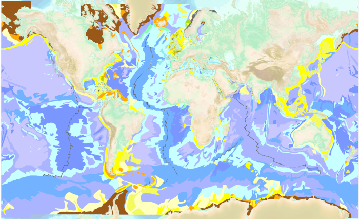
The “World Seabed Sediment Map” product contains geo-referenced digital data, describing the nature of the sediment encountered in different seas and oceans of the world. The objects are all surface areas and the description of an object includes in particular the nature of the sediment including rock-type bottoms.
|
|
Citation proposal
. Worldwide seabed sediment map. https://services.data.shom.fr:/geonetwork/1/api/records/HOM_GEOL_SEDIM_MONDIALE.xml |
Simple
- Date ( Creation )
- 1992-12-01
- Date ( Revision )
- 2026-01-09
- Identifier
- Presentation form
- Digital map
- Credit
-
©Shom
Owner
- Maintenance and update frequency
- Irregular
- Keywords ( Theme )
-
-
sedimentology
-
marine sediment
-
seabed map
-
open data
-
Product
-
- GEMET - INSPIRE themes, version 1.0 ( Theme )
- INSPIRE Spatial scope
- High-value dataset categories
- Use limitation
-
Data may be freely used providing that the source is mentioned as follows "Shom, 2026. Worldwide seabed sediment map, https://dx.doi.org/10.17183/HOM_GEOL_SEDIM_MONDIALE "
- Use limitation
-
Do not use for navigation.
- Use limitation
-
Data may be freely used providing that the source is mentioned as follows "Shom, 2026. Worldwide seabed sediment map, https://dx.doi.org/10.17183/HOM_GEOL_SEDIM_MONDIALE "
- Use limitation
-
Do not use for navigation.
- Access constraints
- License
- Use constraints
- Other restrictions
- Other constraints
- Licence Ouverte version 2.0 Open Licence version 2.0
- Access constraints
- Other restrictions
- Other constraints
- Pas de restriction d'accès public. No public access restrictions.
- Classification
- Unclassified
- Spatial representation type
- Vector
- Denominator
- 500000
- Metadata language
- fre French
- Character set
- utf8 UTF8
- Topic category
-
- Oceans
))
- Supplemental Information
-
* Sediment: An assembly of coarse or fine clastic or biogenic particles transported by one or several means.
* Conglomerate: Sediments in which 50 -100% of the particles are larger than 20 mm.
* Gravel conglomerate: Sediments with a conglomerate matrix and 15 - 50% gravel.
* Gravel: Sediments in which 50 -100% of the particles are between 20 and 2 mm.
* Gravelly sand: A sand matrix comprising 15 - 50% gravel.
* Sand: Sediments in which 50 -100% of the particles are between 2 and 0.5 mm.
* Muddy sand: Sand in which between 5 and 20% of the particles are smaller than 0.05 mm.
* Fine sand: Sediments in which 50 -100% of the particles are between 0.5 and 0.05 mm.
* Fine muddy sandstone: Fine sand in which between 5 and 20% of the particles are smaller than 0.05 mm.
* Silt: Sediments composed of 50 to 100% detrital or biogenic particles between 0.01 and 0.05mm.
* Clay: Sediments composed of 50 to 100% detrital or biogenic particles finer than 0.01mm.
* Mud: Sediments in which 20 -100% of the particles are smaller than 0.05 mm.
- Distribution format
-
-
SHP
(inapplicable
) -
GML
(3.2
)
-
Distributor
- OnLine resource
-
Shom Geoportal
Shom Geoportal
- OnLine resource
-
Shom marketplace
Shom marketplace
- Hierarchy level
- Series
Conformance result
- Date ( Publication )
- 2010-11-23
- Explanation
-
Information sur la conformité au règlement d'interopérabilité des séries et des services de données géographiques.
- Pass
- true
Conformance result
- Date ( Publication )
- 2013-12-10
- Explanation
-
Information sur la conformité de la ressource à une spécification (INSPIRE).
- Pass
- true
- Statement
-
The information used for the development of this product is based on the nature map of the ocean floor published by UNESCO in 1972 and digitized by the Shom in 1995. The purpose of this initial rather coarse map was to provide basic information on to the nature of the seabed and mainly concerned the deep sea. It was gradually improved by the Shom which incorporated more precise maps produced by the Shom, digitized sedimentary maps or summary documents published by various organizations. These maps were previously edited and put into the format of the classification of the nature of the sediments established by the Shom. This version of the world map includes the maps listed in appendix 7.3. These maps were only integrated into the world map when the following conditions were met: - their quality and the interest of their content authorized their integration and validation in the Shom Sedimentological Database (BDSS); - their scale is less than or equal to 1 / 100,000. The product was developed from sedimentary maps identified, digitized and integrated into the BDSS from 1992 to 2020. Some of these maps are synthesis of maps which are themselves derived from the synthesis of very diverse sedimentary data. Many of these compilations were produced by the Shom. The compilation of all these maps in a single document required redefinitions of the overlap zones which were carried out from the data of the morphology and the knowledge of the regional sedimentology (bibliographic and cartographic data).
Metadata
- File identifier
- HOM_GEOL_SEDIM_MONDIALE.xml XML
- Metadata language
- fre French
- Character set
- utf8 UTF8
- Hierarchy level
- Series
- Hierarchy level name
-
Collection de données
- Date stamp
- 2026-03-18T14:32:38
- Metadata standard name
-
ISO 19115:2003/19139
- Metadata standard version
-
1.0
Point of contact
Overviews
Provided by
