 Catalogue Shom
marée
Type of resources
Available actions
Topics
Provided by
Years
Formats
Representation types
Update frequencies
Service types
-
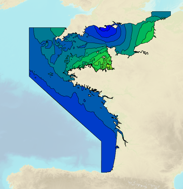
Marnages sur les côtes françaises de La Manche et de l'Atlantique pour le coefficient 120 : marnage maximal pour des conditions atmosphériques moyennes.
-
Marnages sur les côtes françaises de La Manche et de l'Atlantique pour le coefficient 45 - Prépaquet
Marnages sur les côtes françaises de La Manche et de l'Atlantique pour le coefficient 45 : marnage de mortes-eaux moyennes pour des conditions atmosphériques moyennes
-
Marnages sur les côtes françaises de La Manche et de l'Atlantique pour le coefficient 95 - Prépaquet
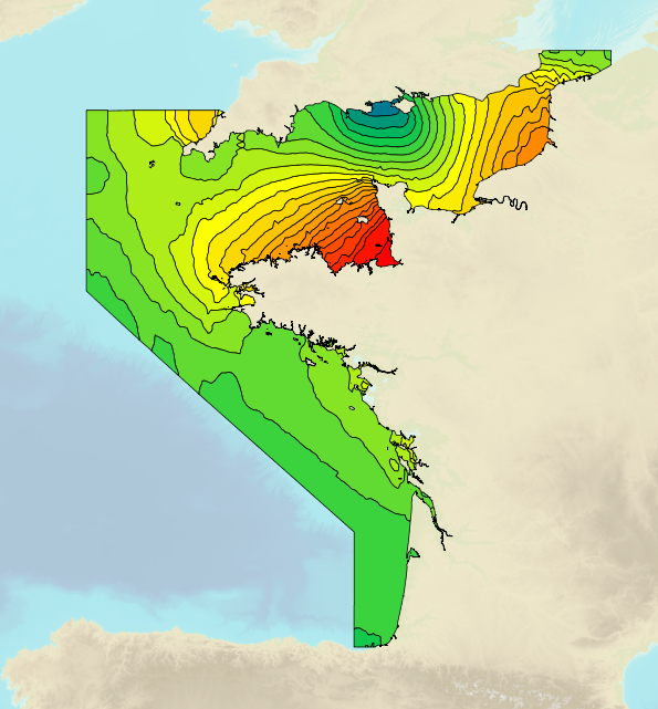
Marnages sur les côtes françaises de La Manche et de l'Atlantique pour le coefficient 95 : marnage de vives-eaux moyennes pour des conditions atmosphériques moyennes.
-
Marnages sur les côtes françaises de La Manche et de l'Atlantique pour le coefficient 20 - Prépaquet
Marnages sur les côtes françaises de La Manche et de l'Atlantique pour le coefficient 20 : marnage minimal pour des conditions atmosphériques moyennes.
-
Le produit « Courants de marée 3D» fournit les informations : · de vitesse de courant de marée (m/s),· de direction (°),· le maximum de courant de marée,· la hauteur d’eau (totale),· le fond Par sélection d'une couche (surface, mi-profondeur, 10m au dessus du fond et fond) et d'une condition de marée (VE : coefficient 95 ou ME : coefficient 45), l'utilisateur accède à une information concernant les courants de marée. Pour chaque point d’une grille irrégulière, les variables sont fournies tous les ¼ h, soit 53 échéances entre 6 heures 30 avant et 6 heures 30 après la pleine mer de Brest. · Les vitesses sont en m/s, · Les directions sont données relativement au Nord géographique et comptées de 0° (Nord) à 360°dans le sens des aiguilles d’une montre. La résolution spatiale est de 1km au large à 100 m en proche côtier, · Les cotes verticales du fond sont référencées par rapport au niveau moyen; · Les coordonnées géographiques (latitude et longitude) sont exprimées dans le système RGF93, système officiel en France.
-
Tidal ranges on the French coasts of the Channel and the Atlantic for a coefficient of 95 : tidal range for mean neap tides for average atmospheric conditions. The tidal range is the difference in height between consecutive low tides and high tides.
-
Tidal ranges on the French coasts of the Channel and the Atlantic for a coefficient of 95 : maximal tidal range for average atmospheric conditions. The tidal range is the difference in height between consecutive low tides and high tides.
-
<em>Surface current predictions computed from statistical values obtained from the IROISE 3D 2011 Telemac hydrodynamic model gridded with a regular 250m spatial resolution.</em><br /> <br /> This service offers a visualization of surface current predictions computed from statistical values obtained from a high resolution hydrodynamic simulation at mean Neap and Spring corresponding to a tide coefficient of respectively 45 and 95. Those statistics are then interpolated/extrapolated every 15 minutes (cubic spline), and for each tide coefficient from 20 to 120 (linear). The statistical currents, initially referenced to Brest high tide, are then referenced to the hour requested by the user using the tide prediction service <a href="http://maree.shom.fr" target="_blank">http://maree.shom.fr</a>. This service was built by Shom and funded by French CCI Métropolitaine Bretagne Ouest (<a href="https://www.bretagne-ouest.cci.bzh/" target="_blank">CCIMBO</a>) in the frame of the <a href="https://www.atlanticblueports.com" target="_blank">Atlantic Blue Port</a> project of <a href="http://www.atlanticarea.eu" target="_blank">Interreg Atlantic Area</a> european program.<br />
-
<em>Surface current predictions computed from statistical values obtained from the IROISE 3D 2011 Telemac hydrodynamic model gridded with a regular 500m spatial resolution.</em><br /> <br /> This service offers a visualization of surface current predictions computed from statistical values obtained from a high resolution hydrodynamic simulation at mean Neap and Spring corresponding to a tide coefficient of respectively 45 and 95. Those statistics are then interpolated/extrapolated every 15 minutes (cubic spline), and for each tide coefficient from 20 to 120 (linear). The statistical currents, initially referenced to Brest high tide, are then referenced to the hour requested by the user using the tide prediction service <a href="http://maree.shom.fr" target="_blank">http://maree.shom.fr</a>. This service was built by Shom and funded by French CCI Métropolitaine Bretagne Ouest (<a href="https://www.bretagne-ouest.cci.bzh/" target="_blank">CCIMBO</a>) in the frame of the <a href="https://www.atlanticblueports.com" target="_blank">Atlantic Blue Port</a> project of <a href="http://www.atlanticarea.eu" target="_blank">Interreg Atlantic Area</a> european program.<br />
-
<em>Surface current predictions computed from statistical values obtained from the IROISE 3D 2011 Telemac hydrodynamic model gridded with a regular 100m spatial resolution.</em><br /> <br /> This service offers a visualization of surface current predictions computed from statistical values obtained from a high resolution hydrodynamic simulation at mean Neap and Spring corresponding to a tide coefficient of respectively 45 and 95. Those statistics are then interpolated/extrapolated every 15 minutes (cubic spline), and for each tide coefficient from 20 to 120 (linear). The statistical currents, initially referenced to Brest high tide, are then referenced to the hour requested by the user using the tide prediction service <a href="http://maree.shom.fr" target="_blank">http://maree.shom.fr</a>. This service was built by Shom and funded by French CCI Métropolitaine Bretagne Ouest (<a href="https://www.bretagne-ouest.cci.bzh/" target="_blank">CCIMBO</a>) in the frame of the <a href="https://www.atlanticblueports.com" target="_blank">Atlantic Blue Port</a> project of <a href="http://www.atlanticarea.eu" target="_blank">Interreg Atlantic Area</a> european program.<br />